
Horní Houžovec
| Horní Houžovec | |||||
|---|---|---|---|---|---|
|
|||||
| Basic data | |||||
| State : |
|
||||
| Region : | Pardubický kraj | ||||
| District : | Ústí nad Orlicí | ||||
| Municipality : | Ústí nad Orlicí | ||||
| Area : | 406 ha | ||||
| Geographic location : | 49 ° 58 ′ N , 16 ° 28 ′ E | ||||
| Height: | 440 m nm | ||||
| Residents : | 59 (2011) | ||||
| Postal code : | 562 01 | ||||
| License plate : | E. | ||||
| structure | |||||
| Status: | District | ||||


_01.jpg)
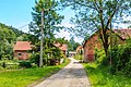
Horní Houžovec (German: Hertersdorf , also Herteschtoff and 1292 villa Herterici ; also Haušowec ) is a municipality part of the town of Ústí nad Orlicí in the district of Ústí nad Orlicí in the East Bohemian region of Pardubický kraj in the Czech Republic .
location
The shape of the district is an elongated cul - de - sac village , 440 m. ü. M. and about 5.5 kilometers east of Ústí nad Orlicí, isolated along the Knapovecký brook. From the west it can be reached from Knapovec via a road, in the north it is bordered by the 531 meter high Zlatá hora (German: 'Goldberg'), in the west by the 'Leith', in the south by the 'Getzelberg'; the village valley itself extends to the east towards the 'Steinbergkamm' (Kammený vrch, 550 to 570 meters above sea level). In the wider area the village is framed by the districts Knapovec, Dolní Houžovec , Horní Dobrouč and Skuhrov u České Třebové .
history
Horní Houžovec was first mentioned in 1292 as villa Herterici . The plague epidemic in Bohemia of 1772 killed many of the town's residents. A predominantly German-speaking population lived in Horní Houžovec until the Second World War . According to a census from 1930, the place had 64 (after another 61) houses with 282 (after another 294) inhabitants (273 of them German-speaking, 9 Czech-speaking). After 1945/46 or after the Second World War, the German-speaking population was expelled and the number of houses was reduced to 40 according to a 1950 count. At the beginning of the 21st century, the number of inhabitants is still far removed from the population figures of the past (e.g. between the years 1850 to 1930).
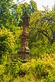
1806: Statue of the Holy Trinity , on the way to Knapovec

Horní Houžovec - cross on the chapel

Horní Houžovec - wayside shrine
Horní Houžovec - house number 38

Horní Houžovec - bus stop


| year | 1850 | 1869 | 1880 | 1890 | 1900 | 1910 | 1921 | 1930 | 1950 | 1961 | 1970 | 1980 | 1991 | 2001 | 2011 |
|---|---|---|---|---|---|---|---|---|---|---|---|---|---|---|---|
| population | 415 | 313 | 312 | 328 | 305 | 313 | 310 | 294 | 124 | 98 | 81 | 63 | 49 | 68 | 59 |

Attractions
- Wayside shrine of the Holy Trinity from 1806
- The wooden chapel of the Visitation of the Virgin Mary from around 1800 is a valuable example of folk architecture in the Ústí nad Orlicí region. It is octagonal in construction, with a wooden sacristy on the side, a flat ceiling, a bulbous dome, a small bell tower above the gable roof, the outer walls are lined with boards in a kind of tongue and groove connection .
Web links
- Hertersdorf on the website Der Schönhengstgau . Accessed: August 14, 2019
- Image archive Hertersdorf on the website Der Schönhengstgau . Accessed: August 14, 2019
Individual evidence
- ↑ http://www.uir.cz/katastralni-uzemi/666823/Horni-Houzovec
- ↑ a b c d Franz JC Gauglitz: home district Landskron. Home book for the city and district of Landskron. Compiled and edited. Zluhan, Bietigheim 1978. p. 196 ff.
- ↑ Historický lexikon obcí České republiky - 1869 - 2011 .