
Hosszúvíz
| Hosszúvíz | |||||
|
|||||
| Basic data | |||||
|---|---|---|---|---|---|
| State : | Hungary | ||||
| Region : | Southern Transdanubia | ||||
| County : | Somogy | ||||
| Small area until December 31, 2012 : | Marcali | ||||
| District since 1.1.2013 : | Marcali | ||||
| Coordinates : | 46 ° 31 ' N , 17 ° 27' E | ||||
| Area : | 7.1 km² | ||||
| Residents : | 44 (Jan. 1, 2011) | ||||
| Population density : | 6 inhabitants per km² | ||||
| Telephone code : | (+36) 85 | ||||
| Postal code : | 8716 | ||||
| KSH kódja: | 30775 | ||||
| Structure and administration (as of 2019) | |||||
| Community type : | local community | ||||
| Mayoress : | Ivett Máté-Botos (independent) | ||||
| Postal address : | Fő u. 45 8716 Hosszúvíz |
||||
| Website : | |||||
| (Source: A Magyar Köztársaság helységnévkönyve 2011. január 1st at Központi statisztikai hivatal ) | |||||


Hosszúvíz is a Hungarian community in the county Marcali in Somogy county . The largely abandoned settlement of Cserfekvés in the southeast belongs to the municipality .
Geographical location
Hosszúvíz is located on the bank of the small river Boronkai-patak , two kilometers northeast of the Mesztegnyő municipality.
Attractions
- Bell Tower ( Harangláb )
- Church ruins in Cserfekvés
- Protected landscape area ( Boronka-melléki Tájvédelmi Körzet )
traffic
Hosszúvíz can only be reached from Mesztegnyő via a side road. Passenger traffic on the railway line from Somogyszob to Balatonszentgyörgy , which runs west of the town, was discontinued at the end of 2009. Rail transport has been replaced by buses.
photos
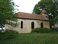
Church ruins in Cserfekvés

Remnants of a stone cross in the cemetery in Cserfekvés

Wetland near Cserfekvés


