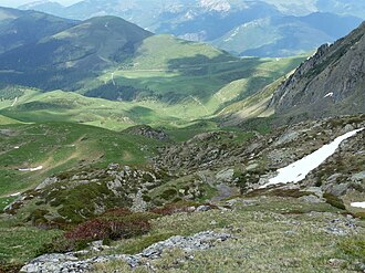
Hourquette d'Ancizan
| Hourquette d''Ancizan | |||
|---|---|---|---|
|
View of the pass from the Clot det Mail |
|||
| Compass direction | Northwest | South east | |
| Pass height | 1564 m | ||
| Department | Hautes-Pyrénées | ||
| Valley locations | Payolle | Ancizan | |
| expansion | D 113 | ||
| Mountains | Pyrenees | ||
| profile | |||
| Ø pitch | 4.8% (414 m / 8.6 km) | 7.7% (738 m / 9.6 km) | |
| map | |||
|
|
|||
| Coordinates | 42 ° 53 '58 " N , 0 ° 18' 20" E | ||
The Hourquette d'Ancizan is a French road pass in the Pyrenees . The 1564 m high crossing is located in the Occitania region ( Hautes-Pyrénées ) and connects the towns of Payolle (district of Campan ) in the valley of the same name ( Vallée de Payolle ) and Ancizan in the Aure valley .
Routing
The entire pass is a narrow paved country road (D113) in good condition (summer 2015). The northwest approach of the Hourquette d'Ancizan branches off in the village of Payolle from the northwest approach of the Col d'Aspin (road D918). Four kilometers before the top of the pass, another 65 meters in altitude descends for one kilometer. According to the signs from the Conseil général des Départements Hautes-Pyrénées , this climb has a total difference in altitude of 414 m along 8.6 km. This corresponds to an average gradient of 4.8%. The south-east approach begins shortly after the town of Ancizan at the intersection with the D30 road. This approach is more demanding for cyclists, as it overcomes a total difference in altitude of 738 m along 9.6 km. This corresponds to an average gradient of 7.7%. Both climbs are equipped with special signs for cyclists at intervals of one kilometer .
Due to its route, the Hourquette d'Ancizan offers an alternative to the Col d'Aspin. After the Hourquette d'Ancizan branches off from the Col d'Aspin in Payolle, both passes end in the Aure Valley on the D929 road 4.8 kilometers away from each other. The Hourquette d'Ancizan has much less traffic than the Col d'Aspin.
Tour de France
The Hourquette d'Ancizan was first on the 2011 Tour de France program . During the Tour of France 2011/12. In the stage from Cugnaux to Luz-Ardiden , it was driven from the southeast, i.e. from Ancizan . It was the first of three gradients in the first category; the stage then led over the Col du Tourmalet and the ascent to Luz-Ardiden. At this first stage in the Pyrenees of the 2011 Tour, Frenchman Laurent Mangel was the first rider to climb the Hourquette d'Ancizan.
Two years later, in 2013, the route was used again from the south-east as part of the 168.5 km long 9th stage from Saint-Girons to Bagnères-de-Bigorre . In contrast to 2011, however, the descent to the stage destination in Bagnères-de-Bigorre followed directly in 2013. That year the Irishman Daniel Martin was at the top at the summit.
Also in 2016 the summit was part of the 8th stage from Pau via Sainte-Marie-de-Campan to Bagnères-de-Luchon in the program of the tour, this time from the northwest as a mountain in the 2nd category. At the top of the pass, Thibaut Pinot came first.
In 2019, the 210 km long 12th stage after the descent from the Col de Peyresourde led from the south-east up to the top of the pass and from there to the destination in Bagnères-de-Bigorre . Simon Yates drove over the top of the pass at the head of the field.
Agricultural use
Like many mountain passes in the French Pyrenees, the Hourquette d'Ancizan also leads through pastures and forests in which farm animals can move freely (see picture gallery). In the case of the Hourquette d'Ancizan, cows , goats , donkeys and horses are found . The animals are usually not fenced in and can freely enter the street, which they do (see picture gallery). Appropriate caution is required. The animals are neither shy nor generally aggressive. However, it is advisable not to approach the animals any more than necessary, especially if there are young animals in the herd.
One of the special mileage marks for cyclists on the Payolle climb
See also
- Elevation profile of the ascent on climbbybike.com
Individual evidence
- ↑ Topographic maps published by the French Institut national de l'information géographique et forestière numbers 1747 ET and 1748 ET, scale 1:25,000.
- ↑ Topographic map published by the French Institut national de l'information géographique et forestière number 1748 ET, scale 1:25,000.
- ↑ Hikers should have due respect for cattle running freely on the alpine pastures: don't trust a cow . Berlin newspaper. Retrieved June 16, 2015.


