
Huey P. Long Bridge (Jefferson Parish)
Coordinates: 29 ° 56 ′ 39 ″ N , 90 ° 10 ′ 8 ″ W.
| Huey P. Long Bridge | ||
|---|---|---|
_cut.jpg) |
||
| use |
Railroad Bridge (Tracks: 2) US Highway (Lanes: 6) |
|
| Crossing of | Mississippi River | |
| place | Jefferson Parish in Louisiana | |
| Entertained by |
New Orleans Public Belt Railroad Louisiana Department of Transportation and Development |
|
| construction | Truss bridge | |
| overall length | 7009 m (railway) 2462 m (road) |
|
| width | 42 m (superstructure) 46 m (supporting frame) |
|
| Longest span | 241 m | |
| Construction height | 35 m | |
| Clear height | 47 m | |
| building-costs | USD 12.8 million (new build 1935) USD 1.2 billion (2013 renovation) |
|
| start of building | 1933 | |
| completion | 1935, 2013 | |
| planner | Modjeski & Masters | |
| location | ||
|
||
 |
||
_location_map.svg)
The Huey P. Long Bridge is a combined rail and road bridge over the Mississippi in Jefferson Parish in the state of Louisiana, USA. It runs six lanes of US Highway 90 and two tracks of the New Orleans Public Belt Railroad , which is the owner of the bridge. The steel - truss bridge with Gerber carrier was in 1926 by Ralph Modjeski designed and built from 1933 to 1935. It was the first Mississippi bridge in the New Orleans metropolitan area and in the entire state. It is named after the then governor Louisiana Huey Pierce Long , who was assassinated shortly before the bridge was completed.
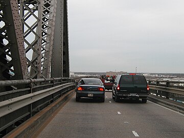
As part of a large-scale infrastructure program in Louisiana, the originally four-lane section of the road was expanded to six lanes between 2006 and 2013, with the main bridge being widened on both sides with additional trusses . Design and planning was carried out from the 1990s by Modjeski & Masters , whose company founder had already designed the original building. In 2012, the ASCE included the bridge in the list of historical milestones in civil engineering . The daily traffic volume in road traffic averaged 40,900 vehicles in 2017.
history
First plans since the 1890s
There was no bridge on the lower Mississippi until the early 1890s . For a long time it seemed impossible to build a bridge due to the width of the river, the unfavorable subsoil conditions and the extensive floodplain . With the Frisco Bridge , George S. Morison designed the first railway bridge for the St. Louis - San Francisco Railway ( Frisco for short ) , which opened in Memphis in 1892 . The Southern Pacific was the first railway company to plan a bridge in New Orleans over the Mississippi and had Elmer Lawrence Corthell - a former partner of Morison - work out plans in 1892; the execution failed during the second phase of the Great Depression from 1873-1896 due to funding. In 1904, the city of New Orleans founded the New Orleans Public Belt Railroad (NOPB), which began operations in 1908 and began a bridge over the river to connect the numerous railroad lines ending in the north and south of the city.
The first state permits were issued at the end of the 1910s, but detailed planning was delayed. In 1924, the Public Belt Railroad Commission - the NOPB's controlling body - hired the bridge engineer Ralph Modjeski , who had worked under Morison for several years and was involved in the construction of the Mississippi Bridge in Memphis as a young engineer. In 1926/1927 Modjeski developed drafts for a high railway bridge with a tanner girder for approval by the United States' War Department. Two lanes for road traffic were planned on the outside of the central truss bridge . Since plans to build a low bridge with a movable bridge part were discarded, the high bridge had to have a clearance height of 47 meters above normal water level in accordance with the requirements of the War Department in order to allow shipping from the port of New Orleans to the inland and into the Gulf of Not to hinder Mexico . This required long access roads for rail traffic, which added up the length of the bridge to a total of seven kilometers. The construction of the river piers in the estuary floodplain of the Mississippi Delta posed a particular challenge . After numerous test drillings in the early planning phase, drillings were carried out again at the future location in 1926 and the drill cores were examined by the founder of modern soil mechanics, Karl von Terzaghi . He recommended the lowering of the pillar foundations in the river bed, which mainly consists of fine sand, to a depth of 30 meters (approx. 50 meters below the water surface), where the bridge piers would only be held by their own weight and friction .
Construction of the bridge in the mid-1930s
With the onset of the Great Depression, financing could not be secured until the end of 1932, and construction work finally began on December 31, 1932. Modjeski's then engineering office Modjeski, Master & Case was responsible for the execution, under the direction of Frank M. Masters . The tender for the construction of the substructure of the main bridge went to Siems-Helmers , who used open caissons made of reinforced concrete with areas of up to 20 m × 30 m for the current pillars , which in turn were drained by large, surrounding cofferdams during the lowering process; the caissons sealed with concrete then formed the foundations of the pillars. The construction of the pillars on land and in shallow water began in the spring of 1933; the central river pillars could only begin with the fall in the water level in summer. The completion of this part of the substructure took place at the end of 1934. The foundations of the driveways were built between January 1933 and May 1934 by MacDonald Engineering , with the anchoring in the ground by pile foundations . The steel trestle bridges resting on them were built by McClintic-Marshall Corp. from July 1933. The east access, which was completed in December, was started and the west access between March and October 1934 continued.
The contract for the manufacture and erection of the truss bridge went to the American Bridge Company , which began manufacturing the steel elements in August 1933 and installing them on the first pillars in March 1934. After completion of the middle piers in July was with the construction truss - Gerber carrier to begin, the one with the help of Derrickkränen mostly in cantilever built; with some steel lattice masts under the cantilevered girders during the construction phase. The gap in the middle section was closed in March 1935 and the entire bridge was completed by October; construction costs totaled 12.8 million US dollars . Although the painting of the steel structure lasted until February 1936, the Huey P. Long Bridge was inaugurated on December 16, 1935. The bridge was named after Louisiana's former governor Huey Pierce Long , who was assassinated in September 1935 in the State Capitol in Baton Rouge .
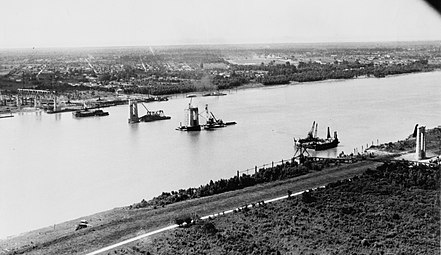
Erection of the reinforced concrete pillars
(1934)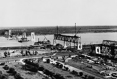
Assembling the superstructure of the main bridge
(1934)
Trestle bridge on the west approach
(completed by the end of 1933)
Construction of Gerber carrier across the Mississippi River in cantilever construction (1935)


Expansion until 2013
Apart from minor repairs and regular painting, the bridge has remained almost unchanged for over 70 years since it was commissioned. With the development of the New Orleans metropolitan area , road traffic increased steadily and the two 2.7 meter lanes in each direction of travel no longer met the requirements of modern expressways with the advent of ISO containers in freight traffic (up to 2.6 meters wide) ( today's standard is over three meters track width). As early as the early 1980s, consideration was given to building another bridge, which, due to the size of the project, could not be financed. In 1986 the Louisiana Department of Transportation and Development (LaDOTD) commissioned the still existing engineering office of the original designers of the bridge (Modjeski & Masters) with feasibility studies for the extension of the 5.5-meter road area. It was then decided to expand to over 13 meters for three 3.4-meter lanes in each direction of travel; financing was provided by the infrastructure program TIMED (Transportation Infrastructure Model for Economic Development) of the state of Louisiana .
The USD 5.2 billion program was approved in 1989 and was originally supposed to run until 2004, but was extended several times and completion was delayed until 2016 by Hurricane Katrina and Hurricane Rita . In addition to the expansion of the Huey P. Long Bridge for It included, among other things, the construction of the John James Audubon Bridge and the widening of the Louisiana highways to over 800 kilometers as well as the modernization and expansion of the international airport and port of New Orleans.
Two-lane carriageway on the outside; 2.7 meter track width (2006)

Sheathing of the river pillars to reinforce and accommodate the steel frame (2007)

Widened trusses on the new steel frame of the pillars (2013)

Three-lane carriageway within the new truss; 3.4 meter track width (2013)


.jpg)

Although Modjeski & Masters began working on the final design of the future bridge in 1992, the project planning extended into the new millennium, so that construction work could not begin until 2006. There have been several changes, especially to the design of the bridge piers of the main bridge, as their foundations from the 1930s had to absorb the additional weight without lowering. In addition, the construction work could only be carried out during ongoing operations and shipping traffic could not be obstructed. The execution was ultimately divided into four main sections and was led by Louisiana TIMED Managers , a joint venture between Parsons Brinckerhoff , GEC Inc. and Michael Baker Corp. :
.png)

- The five pillars of the main bridge were widened between April 2006 and May 2009. Starting from a depth of 1.5 meters - at a step where the granite cladding begins - up to halfway above the water, the piers were given an additional approximately one to three meters thick shell made of reinforced concrete . A steel frame was mounted on the remaining section, which carries the additional framework construction of the superstructure and, thanks to its shape, transfers the forces as centrally as possible into the pillar foundations.
- ( Massman Construction ; $ 99 million)
- Some modifications to the access roads for train traffic were necessary for the new road layout. For this purpose, between October 2006 and June 2008 three steel lattice masts of the Trestle bridges were replaced by several reinforced concrete beam girders, below which parts of the new road accesses run today.
- ( Boh Bros. Construction ; $ 14 million)
- The widening of the trusses of the main bridge was the most difficult and most spectacular construction phase, during which between 2008 and 2012 the trusses of the main bridge from the 1930s were supplemented with another truss per side, creating a three-dimensional steel truss over 40 meters wide. The construction was carried out in stages, with large parts preassembled being floated in and lifted into position using large floating cranes . The largest raised partial frameworks were 161 meters long and 35 meters high with a weight of about 2600 tons; a total of 17,000 tons of steel were used.
- (CTL Group: Joint venture of Massman Construction , Traylor Brothers, and IHI; $ 453 million)
- The construction of the new entrances for road traffic took place in the last construction phase between 2008 and 2013. The original two-lane entrances were attached to cantilever girders to the truss girders with overhead tracks and the steel lattice masts of the Trestle bridges, which could not be extended. The routing of the two traffic routes was completely separated and new reinforced concrete pillars were erected for them, which carry a large number of girder bridges on which the three lanes run in each direction. In addition, the existing roundabouts at the connections to the access roads were replaced by crossings.
- (KMTC Constructors: Joint venture between Peter Kiewit Sons , Massman Construction and Traylor Brothers ; $ 434 million)
Todays use
The New Orleans Public Belt Railroad (NOPB), as the owner of the bridge, has existed for over 100 years and in 2017 operated a route network of 42 kilometers, which, as Terminal and Switching Railroad, brings six Class 1 railroad companies to each other in New Orleans and with the city's port connects. In addition to freight traffic , the city is also served by Amtrak's City of New Orleans , Crescent and Sunset Limited passenger trains, the latter having its origins in a connection to the Southern Pacific , whose route continues over the bridge to this day. After many years of privatization efforts, the takeover of NOPB by the state-controlled Port of New Orleans was announced in 2017 , whereby the city hopes to better manage and control the increasing volume of goods in the long term. The six-lane road section of the bridge is operated by LaDOTD. Although designed for a daily capacity of 100,000 vehicles, the volume of traffic has not increased since 2013 and even decreased from 51,500 vehicles in 2002 to 40,900 vehicles in 2017.
description
The combined railway and road bridge is divided into the 726 m long main bridge and the separate access roads for the two traffic routes, the total length of the railway bridge being 7 km and that of the road bridge being 2.5 km. In its north-south orientation, the bridge describes roughly an S, the main bridge runs between northwest and southeast; According to the literature, however, the article speaks of the west or east side.

Main bridge
The main bridge is from west to east from a 564 m long truss - Gerber beam with spans of 161 m, 241 m and 161 m, wherein in accordance with this special design of a cantilever bridge in the middle part a 153 m long suspended beam is mounted articulated. This is followed by a simple truss with a track of 161 m below. The superstructure has a maximum construction height of 35 m above the current pillars of the Gerber girder, with a continuous width of around 42 m. As a result of the extension, the steel structure now consists of four connected trusses, which are designed as Pennsylvania truss . This design was originally developed by the Pennsylvania Railroad and used until the 1930s. Unlike a simple stand truss , additional posts and additional longitudinal and transverse struts in the lower part are attached here are divided so that the timber-framed fields again and strengthened. The widening increased the weight of the steel structure from the original 17,500 t to 34,500 t.

The superstructure is supported by five reinforced concrete pillars, the foundations of which were lowered into the river bed to a depth of 30 m, with areas of 20 m × 30 m. They have a total length of about 94 m and protrude 44 m out of the water at normal water levels. The pillars were widened up to the support of the steel frame at a height of 28 m, where the pillars still have a footprint of 7.5 m × 24.7 m. At 46 m, the steel frame supporting the extended superstructure is slightly wider than the trusses, as the additional supports are mounted here.
The traffic routes are divided as follows:
- Two railway tracks are led in the originally inner truss, which has a width of 10 m between the central axes of the belts .
- Within the 15 m wide extensions on each side, three 3.4 m wide lanes run with a hard shoulder of 2.4 m on the outside and 0.6 m on the inside.
Driveways
The railroad access roads consist of steel - trestle bridges , being followed on the West side before or four parallelgurtige truss with overhead track to the main bridge of 1 x 101 m and 3 x 81 m length. The following trestle bridge on the west side has a length of 2301 m, on the east side the length is 3289 m; the gradient is 1.25% on both sides. The long driveways were necessary to achieve the clearance height of the main bridge of 47 m, and with a total length of 7009 m the Huey P. Long Bridge is the longest steel railroad bridge in the USA. The mass of steel used for the access roads was around 35,000 t and is therefore just as high as the weight of the current superstructure of the main bridge.
The two-lane driveways for vehicle traffic ran up to the extension on side brackets that were attached to the trusses and steel lattice masts of the Trestle bridges. With the widening of the driveways to three to four lanes per side, these had to be completely separated and now run on their own reinforced concrete pillars on which a large number of girder bridges rest. The gradient here is 4%, which means that the total length of the access roads on both sides only adds up to 2462 m.

See also
- List of bridges over the lower Mississippi
- List of bridge constructions with the participation of Ralph Modjeski
literature
- Frank M. Masters: Mississippi river bridge at New Orleans, Louisiana. Modjeski & Masters, Consulting Engineers, Harrisburg 1941 ( digitized ).
- Wayne Lawrence Coco: Huey P. Long Bridge, Spanning Mississippi River approximately midway between nine & twelve mile points upstream from & west of New Orleans, Jefferson, Jefferson Parish, LA. Historic American Engineering Record, HAER No. LA-17, Atlanta, Georgia 2005 ( online ).
- Tonja Koob Marking, Jennifer Snape: Huey P. Long Bridge. Arcadia Publishing, 2013, ISBN 978-1-4671-1012-9 .
Web links
- Huey P. Long Bridge. New Orleans Public Belt Railroad.
- Huey P. Long Bridge, Spanning Mississippi River approximately midway between nine & twelve mile points upstream from & west of New Orleans, Jefferson, Jefferson Parish, LA. Historic American Engineering Record, HAER LA-17.
- Crossing the Huey P. Long Bridge on Amtrak's Sunset Limited. Video from 2012 on YouTube .
Individual evidence
- ^ Clayton B. Fraser: Nebraska City Bridge. Historic American Engineering Record, HAER No. NE-2, Denver, Colorado 1986, pp. 233, 409.
- ^ About-Us: History. New Orleans Public Belt Railroad. Retrieved July 20, 2018.
- ^ A b c Frank M. Masters: Mississippi river bridge at New Orleans, Louisiana. Modjeski & Masters, Consulting Engineers, Harrisburg 1941, pp. 7-13.
- ^ A b Frank M. Masters: Mississippi river bridge at New Orleans, Louisiana. Modjeski & Masters, Consulting Engineers, Harrisburg 1941, pp. 20-24.
- ^ Frank M. Masters: Mississippi river bridge at New Orleans, Louisiana. Modjeski & Masters, Consulting Engineers, Harrisburg 1941, pp. 34-47.
- ^ Frank M. Masters: Mississippi river bridge at New Orleans, Louisiana. Modjeski & Masters, Consulting Engineers, Harrisburg 1941, pp. 48-54.
- ^ Frank M. Masters: Mississippi river bridge at New Orleans, Louisiana. Modjeski & Masters, Consulting Engineers, Harrisburg 1941, pp. 55-58.
- ^ Frank M. Masters: Mississippi river bridge at New Orleans, Louisiana. Modjeski & Masters, Consulting Engineers, Harrisburg 1941, p. 75 f.
- ^ Frank M. Masters: Mississippi river bridge at New Orleans, Louisiana. Modjeski & Masters, Consulting Engineers, Harrisburg 1941, pp. 63-71.
- ↑ We do the right thing. Modjeski and Masters. Retrieved July 22, 2018.
- ↑ a b c Wayne Lawrence Coco: Huey P. Long Bridge, Spanning Mississippi River…. Historic American Engineering Record, HAER No. LA-17, Atlanta, Georgia 2005, pp. 24-26.
- ^ Louisiana TIMED Program. Center for Innovative Finance Support, Federal Highway Administration. Retrieved July 22, 2018.
- ^ A b c Louise Poirier: Award of Merit: Highways / Bridges: Huey P. Long Bridge Widening Project. ENR Texas & Louisiana, December 16, 2013. Retrieved July 23, 2018.
- ↑ a b Major bridge widening project going to plan. World Highways, October 2011. Retrieved July 22, 2018.
- ↑ David Kanger, Bruce Peterson: Widening of the Huey P. Long Bridge. Tulane Engineering Forum, 2010. Retrieved July 22, 2018.
- ^ A b Jon Thorp: Huey P. Long Bridge Upgrade. Construction Equipment, December 15, 2008. Retrieved July 22, 2018.
- ↑ Huey P. Long Bridge Widening. Massman Construction Co. Retrieved July 23, 2018.
- ↑ A Closer Look: Seeing Double. Amtrak History, July 31, 2014. Retrieved July 17, 2018.
- ^ Michael Popke: Port of New Orleans prepares to take reins at New Orleans Public Belt Railroad. Progressive Railroading, September 2017. Retrieved July 20, 2018.
- ^ Drew Broach: 5 years later, West Jefferson awaits boom from Huey P. Long Bridge expansion. The Times-Picayune, June 21, 2018. Retrieved July 23, 2018.
- ^ Glenn A. Knoblock: Historic Iron and Steel Bridges in Maine, New Hampshire and Vermont. McFarland, Jefferson 2012, ISBN 978-0-7864-4843-2 , pp. 33-37.
- ↑ a b c d Frank M. Masters: Mississippi river bridge at New Orleans, Louisiana. Modjeski & Masters, Consulting Engineers, Harrisburg 1941, pp. 17-19 u. 88
- ↑ Modjeski & Masters, Bruce E. Perterson, LaDOTD: Drawing of Huey P. Long Bridge Widening: Pear I and Pear II General Details. Historic American Engineering Record, HAER LA-17-208, 2005.