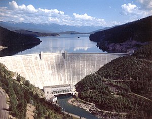
Hungry Horse Dam
| Hungry Horse Dam | |||||||||
|---|---|---|---|---|---|---|---|---|---|
| Hungry Horse Reservoir and Dam | |||||||||
|
|||||||||
|
|
|||||||||
| Coordinates | 48 ° 20 ′ 30 ″ N , 114 ° 0 ′ 30 ″ W | ||||||||
| Data on the structure | |||||||||
| Construction time: | 1948-1953 | ||||||||
| Height of the barrier structure : | 171.9 m | ||||||||
| Height of the structure crown: | 1086.6 m | ||||||||
| Building volume: | 2 243 600 m³ | ||||||||
| Crown length: | 645 m | ||||||||
| Crown width: | 10.36 m | ||||||||
| Base width: | 98.54 m | ||||||||
| Power plant output: | 428 MW | ||||||||
| Data on the reservoir | |||||||||
| Altitude (at congestion destination ) | 1085.79 m | ||||||||
| Water surface | 96.3 km² | ||||||||
| Reservoir length | 55 km | ||||||||
| Storage space | 4,277 million m³ | ||||||||
| Catchment area | 4th 245 km² | ||||||||
| Design flood : | 1 416 m³ / s | ||||||||
The Hungry Horse Dam in the Rocky Mountains in Montana (USA) dammed the South Fork of the Flathead River to the Hungry Horse Reservoir on. The dam is located in Flathead National Forest in Flathead County - 15 miles from the west entrance of Glacier National Park and 20 miles from Kalispell .
The dam is a weight arched wall in a narrow valley and 171.9 m high. Eight kilometers below the dam, the South Fork joins the main stream of the Flathead River. The dam is the tallest in Montana and when it was completed was the fifth tallest dam on earth. The building contract was awarded on April 21, 1948 and the building was finally completed on July 18, 1953 . It is primarily used for power generation and flood protection , as well as irrigation , shipping , leisure and other purposes.
The reservoir is 55 km long. It belongs to the basin of the Columbia River . During periods of high influx, water is stored and then drained and electricity is generated when natural drainage is low. This is important for the other hydropower plants that are below. Five times more electricity can be generated there than at the Hungry Horse power plant. The hydropower plant is located in a concrete and steel building that is 120 m long, 23 m wide and 48 m high. It stands at the foot of the dam over the river. The four generators originally produced four times 71.25 megawatts, a total of 285 MW. In the 1990s, the capacity was increased to four times 107 MW, so that the total output is now 428 MW.
The flood relief is of the “ morning glory ” type. This means that it has a funnel in the storage space into which the water runs and is the highest of this type on earth. Water flowing over the overflow falls 149 m deep. The capacity of the plant is 1416 m³ / s.
In 1995, in addition to other modifications, a new extraction device was installed at the four turbine inlets in order to increase the water temperature in the drain in summer so that the temperature shock for the fish and aquatic animals in the lower reaches is not so great.
The dam is operated by the Federal Bureau of Reclamation . There is a visitor center at the dam, from which you can walk over the top of the wall.
See also
- List of the largest dams on earth
- List of the largest reservoirs on earth
- List of the largest hydroelectric plants in the world
- List of dams in the world
Web links
- US Bureau of Reclamation: Hungry Horse Project, Montana (English)
- US Bureau of Reclamation: Hungry Horse Dam (English)


