
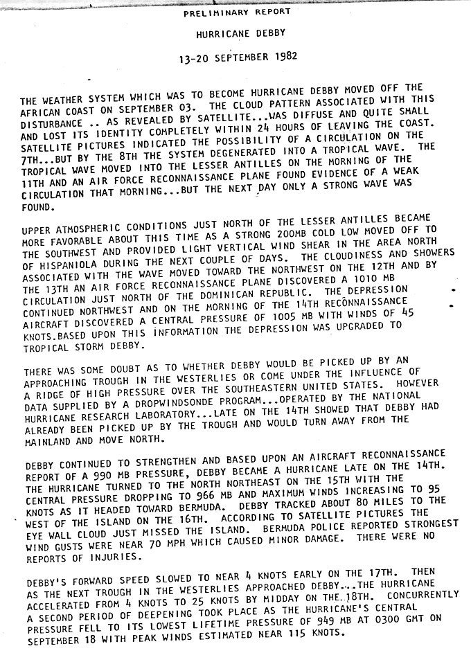
Hurricane Debby (1982)
| Category 4 hurricane ( SSHWS ) | ||
|---|---|---|
 |
||
| Emergence | September 13, 1982 | |
| resolution | 20th September 1982 | |
|
Peak wind speed |
|
|
| Lowest air pressure | 950 mbar ( hPa ; 28.1 inHg ) | |
| dead | No | |
| Property damage | Unknown | |
|
Affected areas |
Bermuda , Newfoundland , Puerto Rico | |
| Season overview: 1982 Atlantic hurricane season |
||
Hurricane Debby was the fifth and strongest storm of the 1982 Atlantic hurricane season . It lasted a week and moved across the Atlantic where it roams Bermuda , Puerto Rico , Nova Scotia and Newfoundland . No casualties or property damage have been reported in connection with Debby.
Debby formed from a tropical disturbance off the coast of West Africa on September 3rd. The storm was initially small and indistinct, moved westward and presumably formed a circulation on September 7 , which disappeared the next day. The wave was able to develop into a tropical low pressure system near the Dominican Republic on September 13 , which intensified into a tropical storm the next day. Debby moved north, grazed Bermuda , then set course for the maritime provinces of Canada . The storm turned eastwards and reached a forward speed of 95 km / h. Debby was absorbed into a powerful storm system over the British Isles on September 20th . At the time of Debby's greatest intensity, wind speeds of 215 km / h and a minimum central air pressure of 950 hPa (mbar) were recorded.
Storm course

A weather disturbance formed off the coast of West Africa on September 3rd. This disturbance was small and indistinct and could no longer be identified within 24 hours. Satellite images showed that the disturbance was able to build up a circulation on September 7th, but this had disappeared the next day. The remaining tropical wave migrated over the Lesser Antilles on September 11th and a reconnaissance flight was scheduled. This showed that the system had a circulation, but the next day only one strong wave was detected. Atmospheric conditions changed and became more conducive to development in the following days as there was light wind shear near Hispaniola . Debby arrived in this area and on the 13th reconnaissance flight on September 13 near the Dominican Republic, the system was classified as a tropical depression.
The 14th reconnaissance flight showed a minimum air pressure of 1005 hPa and wind speeds of 70 km / h in the center of the storm, which is why the NHC declared the system to be Tropical Storm Debby on the morning of 14 September. There were doubts whether Debby's further course would be determined by an approaching trough or the effects of a high pressure ridge over the southeastern United States. The data then submitted to the National Hurricane Center in Coral Gables indicated that Debby was caught in the trough and was moving northward away from land. Debby continued to intensify, becoming a hurricane late on September 14, which had become a Category 2 hurricane on the Saffir-Simpson hurricane wind scale as it approached Bermuda . On September 16, Debby passed the island about 130 km further west and continued north.
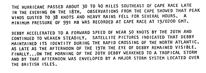
Debby's forward speed decreased to 8 km / h on September 17th when another trough approached in the west wind zone, which Debby then caught. Forward speed then increased to 50 km / h and during this period Debby peaked as a Category 4 hurricane with wind speeds of 215 km / h and a minimum air pressure of 950 hPa. Debby passed directly south of Cape Race and weakened the way east across the Atlantic. Debby maintained hurricane strength as she crossed the North Atlantic and weakened to a tropical storm on September 20 at 6:00 UTC before being absorbed over the British Isles .
For the first time at Debby, the United States Navy carried out a new fact- finding mission on its P-3 flights (these aircraft are also called Hurricane Hunter ). Omega radiosondes , which send signals in a very low frequency range , were deployed. These signals are used to determine the direction and speed of the probe in relation to the movement of the aircraft.
Preparations and implications
Thousands of tourists left Bermuda by plane as Debby approached the island with winds of 185 km / h and it was predicted that the storm center would sweep across the island the next day. Airlines canceled flights to and from Bermuda, buildings were protected with wooden panels and boats and ships rushed to their ports the day before the storm hit. Rescue teams evacuated workers from a drilling rig of the company Mobil , which was in Debby's path, approached the storm.

The rainfall through Debby in Puerto Rico ranged from about 75 mm at the northern end to 250 mm in the south of the island, with the highest value being measured at 327 mm in Peñuelas . The US Virgin Islands reported rainfall of 75 to 125 mm. Heavy rain was recorded on Newfoundland without causing any damage. Nova Scotia reported gale force winds. Heavy gusts of wind caused minor damage to property in Bermuda without harming people. The power supply was briefly interrupted, but was quickly restored.
The name Debby was not removed from the list of tropical cyclone names despite the intensity of the storm due to the lack of damage , but was reused in 1988 , 1994 , 2000 and 2006 ; he's also on the list of names for the 2012 season.
Individual evidence
- ^ A b c d NHC: Hurricane Debby Preliminary Report- Page 1 - Storm History I ( English ) The National Hurricane Center. 1983 . Retrieved July 31, 2008.
- ^ NHC: Hurricane Debby Preliminary Report- Page 2 - Storm History II ( English ) The National Hurricane Center. 1983. Retrieved July 31, 2008.
- ↑ NOAA: NOAA's Gulfstream-IV Jet Takes Hurricane Track Predictions to New Heights ( English ) NOAA. 2007. Retrieved July 31, 2008.
- ^ UPI: Crowds Flee Bermuda With Hurricane Near ( English ) The New York Times. September 16, 1982. Retrieved July 31, 2008.
- ↑ The Daily Intelligencer (Ed.): Hurricane Debby Gains Strength . September 16, 1982 (English).
- ^ The Syracuse Herald Journal (ed.): Newfoundland battered . September 19, 1982 (English).
- ^ David Roth: Incipient Stage of Debby - September 12-14, 1982 ( English ) Hydrometeorological Prediction Center. 2007. Archived from the original on October 8, 2006. Retrieved July 31, 2008.
- ↑ Associated Press: A Wandering Hurricane Brushes Past Bermuda ( English ) The New York Times. September 17, 1982. Retrieved July 31, 2008.