
1988 Atlantic hurricane season
 All the storms of the season | |
| Formation of the first storm |
30th May |
|---|---|
| Dissolution of the last storm |
November 24th |
| Strongest storm | Gilbert - 888 hPa ( mbar ), 160 kn (295 km / h ) |
| Tropical lows | 19th |
| Storms | 12 |
| Hurricanes | 5 |
| Severe hurricanes ( Cat. 3+ ) | 3 |
| Total number of victims | > 550 |
| Total damage | $ 7 billion (1988) |
|
Atlantic hurricane seasons 1986 , 1987 , 1988 , 1989 , 1990 | |
The 1988 Atlantic hurricane season officially began on June 1 and ended on November 30. It is during this period that most of the tropical cyclones form in the northern Atlantic Ocean , as suitable conditions exist - such as a warm ocean , moist air, and little wind shear - to allow tropical cyclones to form.
Tropical activity began with the first tropical depression on May 30th before the start of the official hurricane season, but Tropical Storm Alberto did not develop until August 8th, about a month later than usual. The last storm of the year was Tropical Storm Keith, which went extra-tropical on November 24th.
During the 1988 Atlantic hurricane season there were 19 tropical depressions , twelve of which were tropical storm strength; a system was only classified as a tropical storm during the post-analysis. Five storms developed into hurricanes, at least three of which reached category three on the Saffir-Simpson hurricane wind scale and are therefore considered major hurricanes. Four hurricanes and three tropical storms hit the mainland.
The hurricanes Gilbert and Joan were devastating hurricanes in the Caribbean and the Gulf of Mexico . Gilbert even reached a new record low for air pressure in the Atlantic Basin, which was only undercut by Hurricane Wilma in the extraordinary hurricane season of 2005 . Together, the two storms left more than 500 deaths and more than $ 12.5 billion in damage.
Season forecasts
| source | date |
Storms |
Number of hurricanes |
Cat. 3+ |
|
| CSU | Average (1950–2000) | 9.6 | 5.9 | 2.3 | |
| NOAA | Average (1950–2005) | 11.0 | 6.2 | 2.7 | |
| Record values (high) | 28 | 15th | 8th | ||
| Record values (low) | 4th | 2 | 0 | ||
|
|
|||||
| CSU | June | 11 | 7th | X | |
|
|
|||||
| Actual activity | 12 | 5 | 3 | X | |
Predictions of expected activity for the coming hurricane season were made in 1988 by hurricane expert William M. Gray and his colleagues at Colorado State University .
The forecast from June 1988 was eleven storms, seven of which would reach hurricane status (no estimate was made at the time of how many of them could become major hurricanes ).
Seasonal activity
The 1988 Atlantic hurricane season began two days before it officially began on May 30th. The season had an above-average course, as 19 tropical cyclone systems formed. Twelve of these low pressure areas reached the strength of a tropical storm and five of these storms became a hurricane. For the first time in 27 years, three hurricanes reached the strength of a major hurricane, that is, a hurricane that reached at least category three on the Saffir-Simpson hurricane wind scale. Four hurricanes and three tropical storms hit the land. 550 people were killed and the damage caused added up to 7 billion US dollars (1988). The last storm of the season broke up on November 14th, a good two weeks before the official end of the season.
Activity in the first two months of the season was limited because air currents in the upper troposphere caused strong wind shear . Though powerful tropical waves broke off the coast of Africa, they usually quickly lost their intensity as they crossed the Atlantic Ocean. Because of this, no tropical depression formed in June and July. The wind shear then decreased in August. The error rate of the official train path forecasts was between 30 and 40% below the average of the previous ten years. The forecasts for the next 24, 48 and 72 hours were more accurate than in the previous eighteen years. The accuracy of the calculations for 1988 was no longer achieved until the 1996 Atlantic hurricane season.
Storms
Tropical Depression One
| Tropical depression | |||
|---|---|---|---|
|
|||
| Duration | May 30th - June 2nd | ||
| intensity | 30 kn (55 km / h ) (1 minute) , 1004 hPa | ||


The first tropical depression of the season formed on May 30 in the northwestern Caribbean . On the way north, it came to an area with unfavorable conditions and therefore turned into a low pressure trough on June 2nd in Floridastraße .
The rainfall associated with the system lasted over Cuba for a week. A total of 600 mm of precipitation was recorded in the center of Cuba . In the resulting floods 21 people were killed and thousands lost their homes. The peak rainfall was 1025 mm and reached a daily maximum of 867 mm. According to records dating back to 1963, this was the third highest known amount of precipitation in Cuba from a tropical cyclone.
In Cuba, the province of Cienfuegos was hardest hit. In Camagüey , the low pressure area triggered a tornado that destroyed buildings and five Soviet planes, 65,000 residents had to be evacuated, with some helicopters and amphibious vehicles being used.
Tropical storm Alberto
| Tropical storm | |||
|---|---|---|---|
|
|||
| Duration | August 5th - August 8th | ||
| intensity | 35 kn (65 km / h ) (1 minute) , 1002 hPa | ||


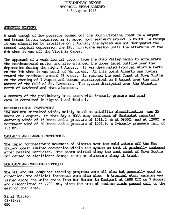
The first named tropical storm of the season developed from a weak low pressure trough off the coast of South Carolina on August 4th . On the next day a circulation was determined by satellite evaluations and on August 6th the NHC determined the formation of a tropical low pressure area. An approaching weak weather front was pushing the low northeast, improving its outflow at altitude. On August 7, the system was upgraded to Tropical Storm Alberto; this was at the time south of Nantucket , Massachusetts .
At 41.5 ° north latitude, Alberto became a tropical storm further north than any other tropical Atlantic cyclone since 1941, when tropical cyclones became reliable. The storm increased its forward speed northeast to 25 knots and struck western Nova Scotia on the evening of August 7 , where it had little impact. Above the cold waters of the Gulf of Saint Lawrence , Alberto became extratropical on August 8th and dissolved north of Newfoundland shortly afterwards . Alberto caused light rains and gusty winds along his track, but no significant damage was recorded in connection with these.
Tropical storm Beryl
| Tropical storm | |||
|---|---|---|---|
|
|||
| Duration | August 8th - August 10th | ||
| intensity | 45 kn (85 km / h ) (1 minute) , 1001 hPa | ||


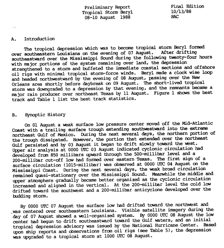
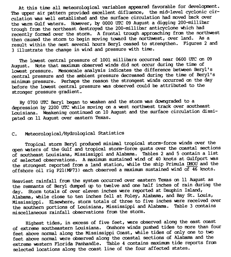
The third tropical depression of the year formed on August 7th from a bottom depression in southeast Louisiana . The system is doing better as it drifted towards the mouth of the Mississippi River . Soon the convection of the system was strong enough that the National Hurricane Center (NHC) recorded the warning about the system. On August 8, storm warnings were triggered for the coast from Louisiana to the Florida Panhandle . Over the open Gulf of Mexico, Beryl developed a light tropical storm and gusts hit the coasts of Louisiana, Mississippi, and Alabama . Precipitation from Beryl was extensive in the central coastline, reaching 400mm at Dauphin Island , Alabama.
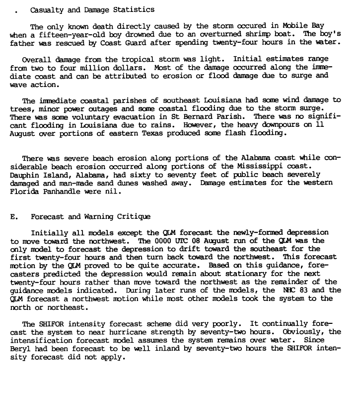
Beryl's circulation center, equipped with a well-developed outflow , migrated over warm water on August 9 and the prospects for further development were favorable, but an approaching front from the northwest turned the orbit of the storm back to the mainland in southeast Louisiana. When Beryl pulled over the Bayou Teche the next morning , the system had weakened into a depression. The damage caused by Beryl was minor and, as far as was known, the effects of Beryl killed one person.
Tropical Depression Four
| Tropical depression | |||
|---|---|---|---|
|
|||
| Duration | August 12th - August 15th | ||
| intensity | 30 kn (55 km / h ) (1 minute) , 1013 hPa | ||


Tropical Low Pressure System Four evolved from a tropical wave on August 12 over the southern Bahamas . The system migrated north-northwest and landed at Jacksonville , Florida the next day . The system brought gusty winds and thunderstorms to the coasts of Florida and Georgia without causing major damage. It then moved across southern Georgia and the northeastern section of the Gulf Coast , leaving up to 180mm of rainfall in the southeastern states . The system made it over water again, but still disintegrated on August 15 near the mouth of the Mississippi River .
The initial projections assumed that the low pressure system would develop into the third tropical storm of the year. However, it lost its well-defined center due to adverse altitude conditions and the influence of the Bahamas. According to the National Weather Service , the low pressure area reached wind speeds of 80 km / h.
Tropical Depression Five
| Tropical depression | |||
|---|---|---|---|
|
|||
| Duration | August 20 - August 31 | ||
| intensity | 30 kn (55 km / h ) (1 minute) | ||


The fifth tropical depression of the year in the Atlantic basin formed on August 20 near Cape Verde . At this point in time, heavy rains and winds of up to 54 km / h were registered. The Depression drifted north-northwest of the islands for the next three days without much development.
On August 24th, forward speeds increased to 25 km / h and the direction of the train turned west. Cool water weakened the system into a tropical wave on August 26th . This continued in a west-northwest direction, with no prospect of resurgence, but on August 30, the remaining low about 290 km southeast of the coast of North Carolina turned into a low pressure area again and the Washington office of the National Weather Service tracked the system as a storm center until it was integrated into the frontal zone on September 1st .
Tropical Depression Six
| Tropical depression | |||
|---|---|---|---|
|
|||
| Duration | August 20 - August 23 | ||
| intensity | 25 kn (45 km / h ) (1 minute) | ||


Tropical Depression Six was formed from a tropical wave that broke off the coast of Africa on August 12 and crossed the Atlantic westward. On August 20, during the approach to the Leeward Islands , the NHC declared the system to be a tropical low pressure system, which, however, encountered less favorable conditions after crossing the archipelago. Since it was quite stormy on the islands, a further intensification of the system into a tropical storm over the warm waters of the western Caribbean was expected; however, the system was downgraded to a tropical wave on August 23 near Jamaica . This then migrated further west across the Caribbean, crossed Central America and finally developed into Hurricane Kristy in the eastern Pacific .
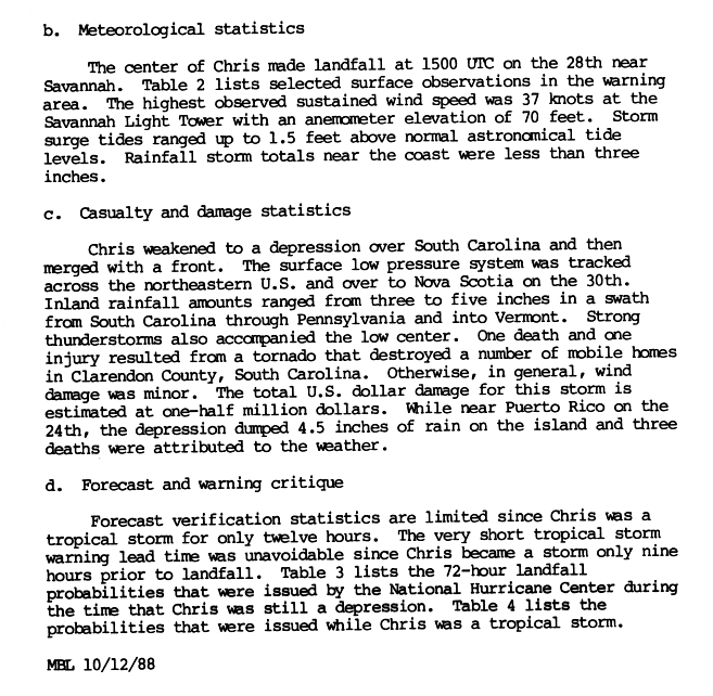
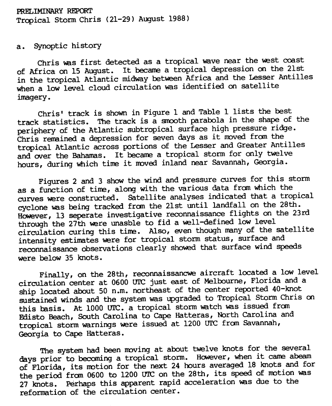
Tropical storm Chris
| Tropical storm | |||
|---|---|---|---|
|
|||
| Duration | August 21st - August 30th | ||
| intensity | 45 kn (85 km / h ) (1 minute) , 1005 hPa | ||


Chris formed from a strong tropical wave that broke off the West African coast on August 15th. On August 21, a convection area separated in the northern part of the wave and developed into Tropical Low Pressure Area Seven. The storm migrated westward across the Atlantic on the southern edge of a subtropical high pressure ridge. Over the next seven days, there was little evidence of an intensification of the system, which was still a tropical depression when it crossed the Leeward Islands and Greater Antilles, and the Bahamas .
The system happened on August 24th south of Puerto Rico and locally left up to 300 mm of precipitation on the island. The storm is responsible for three deaths in Puerto Rico. On August 28, the system was upgraded to Tropical Storm Chris; at this point it was migrating northward off the Florida coast. In Savannah , Georgia , the storm came ashore. Chris causes slight damage in this area from wind and rain. During the weakening to tropical depression, Chris dumped heavy rains over South Carolina . Then the system combined with a cold front and became extra-tropical. On its way along the east coast , the forward speed accelerated and after the passage of Nova Scotia it dissolved on August 30th. Violent thunderstorms triggered a tornado in South Carolina that killed one person.
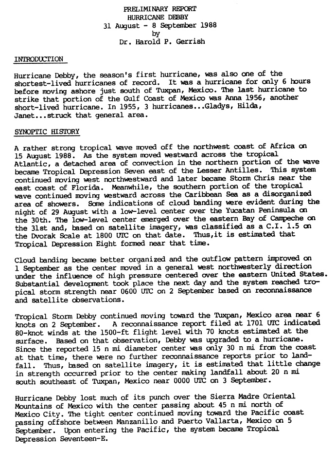
Hurricane Debby
| Category 1 hurricane | |||
|---|---|---|---|
|
|||
| Duration | August 31st - September 8th | ||
| intensity | 65 kn (120 km / h ) (1 minute) , 987 hPa | ||


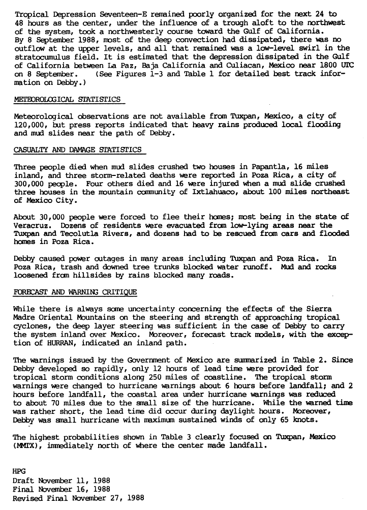
Debby formed from the southern part of the wave, from which Tropical Storm Chris had emerged and whose convection area broke out of the wave as the seventh tropical low pressure area of the year. This southern part migrated westwards as a poorly organized rain shower area. The system did not develop any further until it reached the Bahía de Campeche from Yucatán on August 31 . At around midnight local time, the NHC classified the system directly off the coast as Tropical Depression Eight. The system drifted west-northwest across the western Gulf of Mexico , reaching the strength of a tropical storm in the early hours of September 2. In the course of the day Debby was then declared a hurricane based on the observations of a reconnaissance flight. At the time of its greatest intensity, Debby's center was only 50 km from the coast. The center landed at Tuxpan six hours later without weakening significantly . The consequences of the hurricane were high wind speeds, flash floods and landslides, which killed a total of ten people.
Debby weakened considerably over the mountains of the Sierra Madre Oriental , the remnants of the system crossed Mexico towards the Pacific Ocean . The center surfaced again at Manzanillo on September 5th. The system was classified as Tropical Depression Seventeen-E in the Pacific Basin before it disintegrated in the Gulf of California on September 8 .
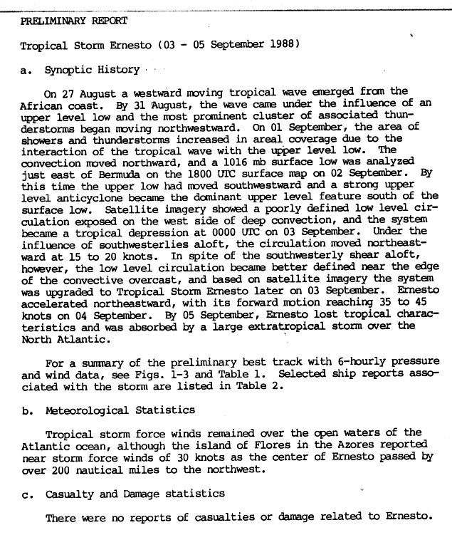
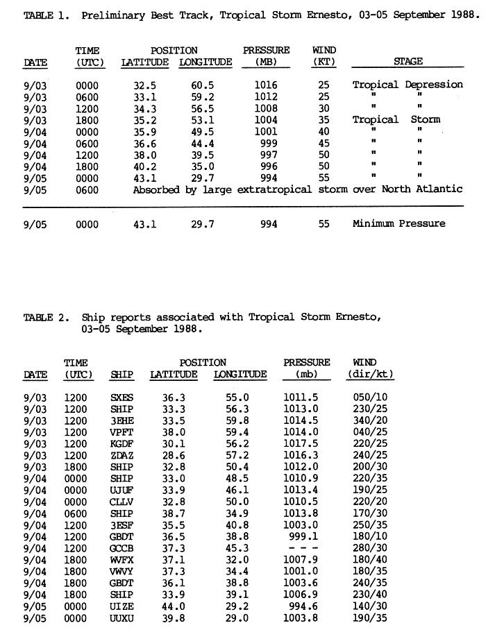
Tropical storm Ernesto
| Tropical storm | |||
|---|---|---|---|
|
|||
| Duration | September 3 - September 5 | ||
| intensity | 55 kn (100 km / h ) (1 minute) , 994 hPa | ||


On September 2, near Bermuda , a thunderstorm zone with a north-westerly moving tropical wave developed into a near-surface low pressure area. This initially remained poorly defined and could not combine with the convection, but on September 3rd it became a tropical depression. Under the influence of the west wind zone , the forward speed accelerated northeast to 80 km / h. On the evening of September 3rd, the system was declared Tropical Storm Ernesto. Ernesto increased in intensity even after the system lost its tropical properties. Ernesto was absorbed by a major extra-tropical cyclone on September 5th.
During its life cycle, Ernesto stayed at sea and its strong winds only affected the sea surface and some islands, such as the Azores , where the strongest gusts of wind were observed on Flores Island . No reported damage to life or property has been caused by Ernesto.
Tropical Depression Ten
| Tropical depression | |||
|---|---|---|---|
|
|||
| Duration | September 3 - September 4 | ||
| intensity | 25 kn (45 km / h ) (1 minute) , 1004 hPa | ||


An extensive depression developed in the western Gulf of Mexico on September 2nd . The convection increased rapidly and the NHC declared the system Tropical Depression Ten the following day when it was located approximately 260 km west-southwest of Morgan City , Louisiana . Meteorologists were quick to issue storm warnings for the coast between Cameron , Louisiana and Apalachicola , Florida , as the storm was moving northeast at a forward speed of 14 miles per hour. However, the system soon connected to the frontal zone that had caused its acceleration.
Oil rigs along the coast of the Gulf of Mexico registered wind gusts of up to 65 km / h. The southeast of Texas and Louisiana were hit by heavy rainfall, with Biloxi in Mississippi recording one of the highest values with around 220 mm of rainfall. No damage was reported in connection with this tropical depression.
Hurricane Florence
| Category 1 hurricane | |||
|---|---|---|---|
|
|||
| Duration | September 7th - September 11th | ||
| intensity | 70 kn (130 km / h ) (1 minute) , 983 hPa | ||


A band of clouds accompanied by a cold front reached the Gulf of Mexico from Texas on September 4th . This band of clouds parted over the central gulf and the northern half developed into a front moving northeastward. The convection over the southern half, which had been stationary until then, increased and was located around the center of the cloud band. A shallow circulation formed on September 7, and storm warnings began to be issued on that day.
The low pressure area moved eastwards and came under the influence of a dissolving trough. It intensified into Tropical Storm Florence, which swung north on September 9 and reached hurricane strength shortly before reaching the Mississippi Delta . Over southwest Louisiana , the hurricane weakened rapidly and lost convection as it swept over the New Orleans area . Near Baton Rouge , the system was downgraded to a tropical depression that dissolved over northeast Texas the following day.
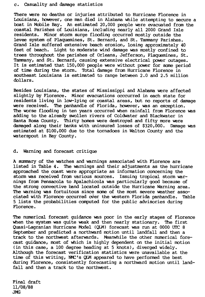
At the beginning of its existence, the system dumped large amounts of precipitation over the Yucatán. A storm surge occurred east of the landfall point when it hit the Louisiana coast. The wind caused power outages, one person was killed in Alabama and flash floods caused significant damage and destroyed homes in Florida, particularly in Santa Rosa County .
Hurricane Gilbert
| Category 5 hurricane | |||
|---|---|---|---|
|
|||
| Duration | September 8th - September 20th | ||
| intensity | 160 kn (295 km / h ) (1 minute) , 888 hPa | ||


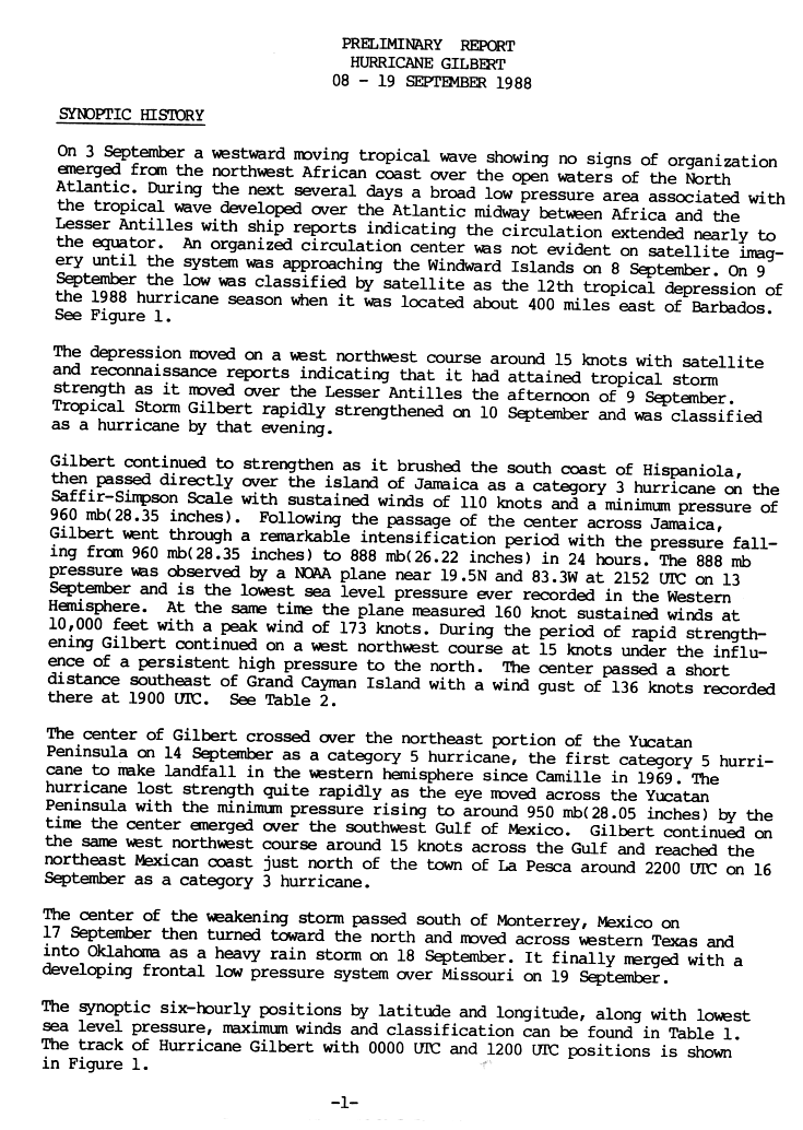
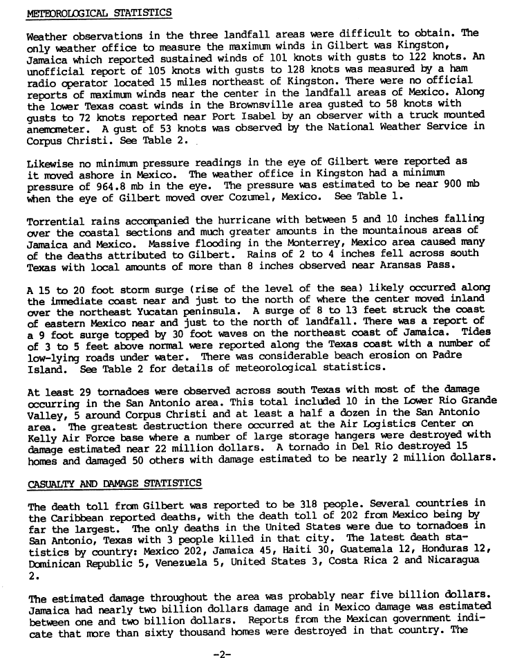
The twelfth tropical low pressure system formed directly east of the Leeward Islands on September 8 and migrated in a west-northwest direction. On September 9th, the NHC gave the name Gilbert because the low has meanwhile developed into a tropical storm. This turned west and intensified into a severe hurricane on September 11th. Gilbert continued to strengthen as he roamed the south coast of Hispaniola . It moved directly over Jamaica and caused heavy rainfall in the mountainous country there. After the center got afloat again, Gilbert regained strength. On September 13, the air pressure fell by 72 mbar ( hPa ), which was the fastest pressure drop in the Atlantic basin since records began until Hurricane Wilma . Gilbert's lowest air pressure was 888 mbar (hPa) and up to Wilma was the lowest air pressure ever measured in the western hemisphere.
Gilbert weakened slightly, but still hit Yucatán as a Category 5 hurricane. When the Eye got overland, the storm rapidly lost strength and hit the Gulf of Mexico as a category two hurricane on September 15. The hurricane continued on a northwestern orbit and again reached category four on the Saffir-Simpson hurricane scale. On September 16, the storm crossed a coastline for the third and final time. This happened near La Pesca and the constant wind speeds at this point were around 200 km / h. The storm center passed south of Monterrey , Mexico , on September 17, causing severe flooding in the city. The remaining low Gilbert turned north and connected to a frontal low pressure system over Missouri .
Hurricane Gilbert was the strongest hurricane observed in the Atlantic Basin until 2005 , when this weather record was broken by Hurricane Wilma. The storm caused $ 5 billion in damage to the Caribbean and Central America. It was the last hurricane to land in Mexico as a category five hurricane until Hurricane Dean 2007. The number of victims was given as 433, most of them in Mexico.
Tropical Storm Thirteen
| Tropical storm | |||
|---|---|---|---|
|
|||
| Duration | September 7th - September 10th | ||
| intensity | 50 kn (95 km / h ) (1 minute) , 994 hPa | ||


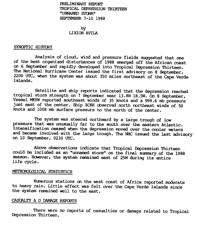
A well-organized tropical disruption broke off the African coast on September 6 and quickly evolved into Tropical Depression Thirteen. The NHC began issuing warnings two days later when the system was 565 km northeast of Cape Verde. The follow -up analysis, based on satellite images and observations by ships, determined that the system had reached the strength of a tropical storm on September 7th .
For three days, a low pressure trough south of the system pushed the low pressure area in a north-northwest direction over cooler water. Heavy rains, but no damage, were reported along the coast of West Africa . The system weakened and eventually connected to the trough. The storm was only considered as such in the NHC's annual review and was therefore not given a name.
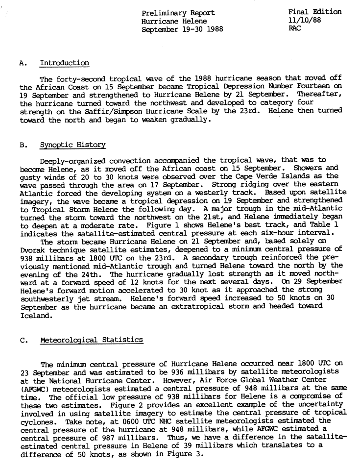
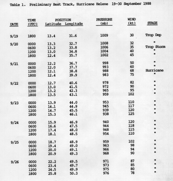
Hurricane Helene
| Category 4 hurricane | |||
|---|---|---|---|
|
|||
| Duration | September 19 - September 30 | ||
| intensity | 125 kn (230 km / h ) (1 minute) , 938 hPa | ||


A well-organized tropical wave broke off the African coast on September 15th. Showers and gusty winds were recorded as this disturbance moved across Cape Verde. Over the next few days the convection increased as a strong front over the eastern Atlantic drove the low west. Based on satellite images, the system was classified as a tropical depression on September 19 and upgraded to Tropical Storm Helene the day after.
When Helene reached about the middle of the Atlantic, the direction of movement turned to the northwest under the influence of a low pressure trough. Favorable conditions allowed the storm to rapidly intensify its pressure and on October 21, Helene was declared a hurricane over the tropical Atlantic. The storm continued to intensify and turned into a severe hurricane late in the evening of September 22nd, reaching category four on the Saffir-Simpson hurricane wind scale the following day.
On September 23, Helene turned north and hiked in that direction for a week. During this time, the intensity of the hurricane decreased continuously. Helene reached the southern limit of a strong jet stream on September 28, which intensified the outflow of the storm and briefly contributed to its re-intensification. Helene's forward speed increased to 100 km / h on September 30th when the system became extra-tropical. With nine days as a hurricane, Helene was the longest-lived hurricane of the 1988 Atlantic hurricane season.
Tropical Depression Fifteen
| Tropical depression | |||
|---|---|---|---|
|
|||
| Duration | September 27th - September 28th | ||
| intensity | 25 kn (45 km / h ) (1 minute) | ||


While Hurricane Helene was moving across the mid-Atlantic, the Tropical Low Pressure Area Fifteen formed on September 27, also near Cape Verde. The system moved westward at 20-30 km / h, but quickly weakened and was downgraded to a tropical wave on September 28, without ever approaching land.
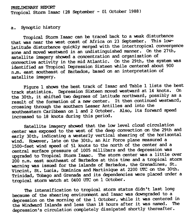
Tropical Storm Isaac
| Tropical storm | |||
|---|---|---|---|
|
|||
| Duration | September 28th - October 1st | ||
| intensity | 40 kn (75 km / h ) (1 minute) , 1005 hPa | ||


Isaac has its origins in a disturbance on the west coast of Africa from which the system broke on September 23rd. The system crossed the Atlantic along the intertropical convergence zone and the convection developed continuously better. On September 29, the system was classified as Tropical Depression Sixteen, approximately 1,450 km southeast of Barbados . The track swiveled two degrees north, possibly by creating a new center. On September 30th, the system was upgraded to a tropical storm.
Western wind shears prevented a further drop in air pressure and under these conditions the storm lasted only a short time. On October 1st, Isaac was just a low pressure area, which shortly afterwards completely dissolved. No property damage or personal injury was recorded in the Atlantic basin due to Isaac. The rest of the low pressure area reached the Pacific Basin via Central America, where they regenerated to the Tropical Low Pressure Area Twenty-one-E .
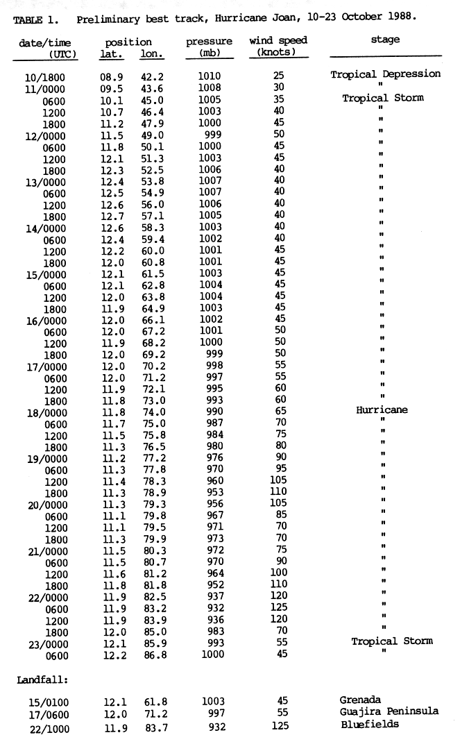
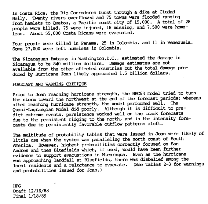
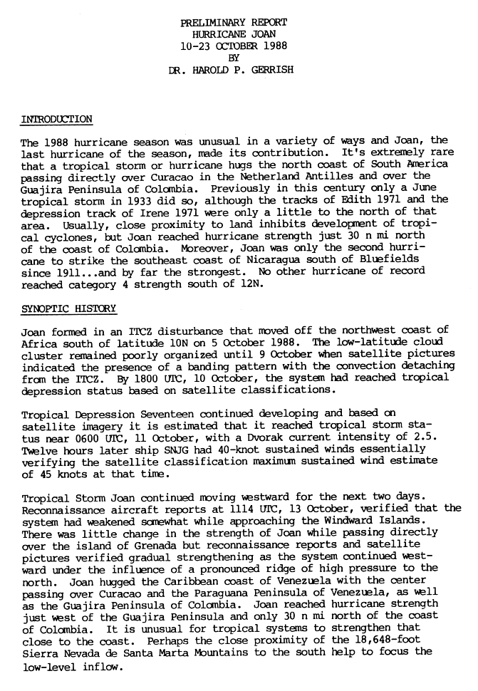
Hurricane Joan
| Category 4 hurricane | |||
|---|---|---|---|
|
|||
| Duration | October 10th - October 23rd | ||
| intensity | 125 kn (230 km / h ) (1 minute) , 932 hPa | ||


On October 10, a disturbance in the intra-tropical convergence zone formed the seventeenth tropical low pressure area of the season. In the following two days, the system migrated northwest and intensified into Tropical Storm Joan. After Joan crossed the Lesser Antilles, the storm moved along the coast of South America . It crossed the Guajira Peninsula on October 17th and then quickly reached hurricane strength just 50 km from the coast. On October 19, Joan had turned into a major hurricane that was moving further west. Just before landfall at Bluefields , Nicaragua on October 22nd as a category four hurricane, Joan reached its greatest strength. Joan was the furthest south-trending hurricane recorded to date. That record was later broken by Hurricane Ivan . Joan stayed well organized in crossing Nicaragua and arrived in the eastern Pacific at the strength of a tropical storm. There Joan was given the name Tropical Storm Miriam . However, Miriam steadily lost strength and broke up on November 2nd.
Hurricane Joan killed 148 people in Nicaragua and 68 more in the other affected states. Property damage in Nicaragua accounts for about half of the total $ 2 billion in damage. Joan caused heavy rains and landslides in areas of the extreme southern Caribbean Sea. The course along the north coast of South America was extraordinary. Joan was the first tropical cyclone to enter the Pacific basin from the Atlantic basin after Hurricane Greta in 1978.
Tropical Depression Eighteen
| Tropical depression | |||
|---|---|---|---|
|
|||
| Duration | October 20 - October 21 | ||
| intensity | 30 kn (55 km / h ) (1 minute) | ||


A tropical wave that broke off the coast of Africa in the wake of Joan's wake developed in the southern central Caribbean on October 19. Due to its proximity to Hurricane Joan - the distance between the two systems was only about 800 km - the Tropical Depression Eighteen could not develop much further. The system broke up on October 21st. Previously it brought heavy rains to the Netherlands Antilles .
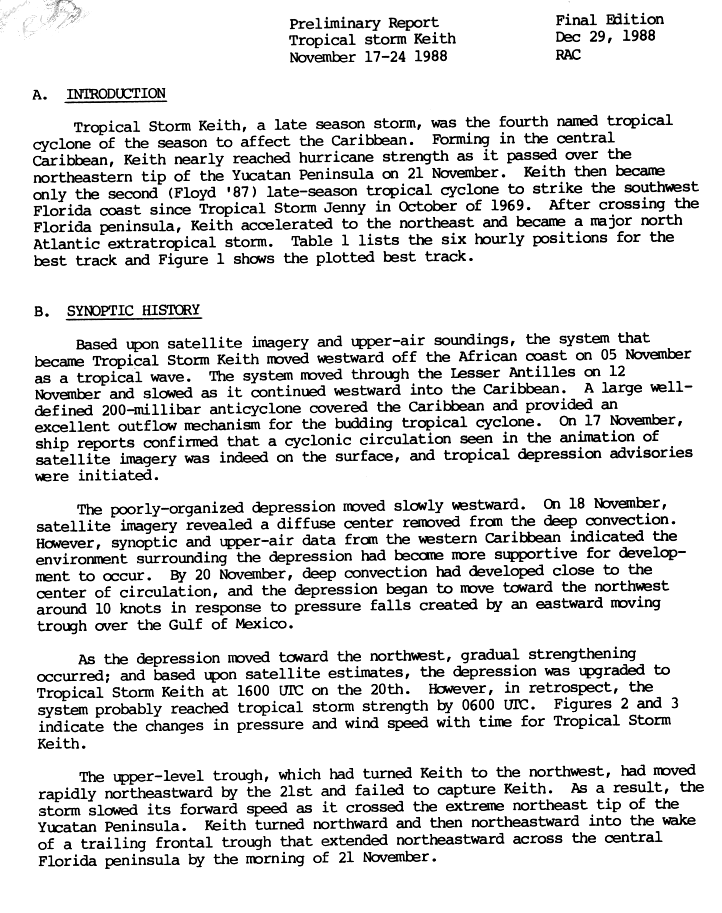
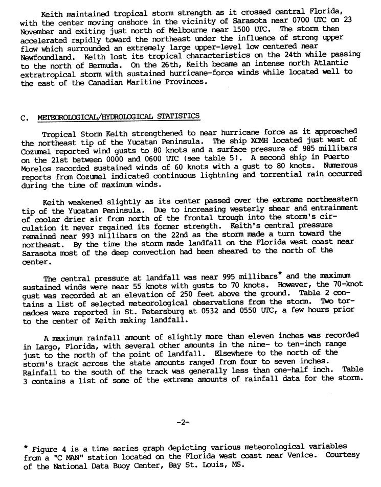
Tropical storm Keith
| Tropical storm | |||
|---|---|---|---|
|
|||
| Duration | November 17th - November 24th | ||
| intensity | 60 kn (110 km / h ) (1 minute) , 985 hPa | ||


The last storm of the season formed on November 17th from a tropical wave south of Haiti in the Caribbean Sea. This moved slowly westwards and on November 20th reached the strength of a tropical storm. Keith developed rapidly, peaking in winds of 110 km / h just before the system moved over the northeastern Yucatan . A trough at high altitude then forced Keith northeast and wind shear combined with cool, dry air weakened the storm to a minimal tropical storm. This created a typical November weather pattern. Keith regained strength over the southeastern Gulf of Mexico and then landed again near Sarasota , Florida on November 23rd. The storm crossed the state towards the open Atlantic and became an extra-tropical low pressure system near Bermuda on November 24, reaching sustained hurricane-force winds on its way across the Atlantic.
At the beginning of its existence, Keith caused heavy to heavy rainfall in Honduras , Jamaica and Cuba . There was little damage to Mexico , which had not yet recovered from the devastating effects of Hurricane Gilbert two months earlier. Keith was the last of four named tropical storms of 1988 to hit the United States area; In central Florida, the storm brought heavy rains and high surf, resulting in flooding, fallen trees, disrupted utility lines, and coastal erosion . Damage was widespread but quite minor; they amounted to 7.3 million US dollars .
Season overview

Storm names
The following list of names was used to name the storms in the Atlantic hurricane season; Names that were not removed from the list of tropical cyclone names were reused during the 1994 Atlantic hurricane season . This list is identical to the list of names used during the 1982 Atlantic hurricane season . The storm names Gilbert, Isaac, Joan, and Keith were used for the first time. Florence and Helene were not used in 1982, but were used in earlier years. Unused names are shown in light gray font.
|
The World Meteorological Organization removed two names from the list in spring 1989, Gilbert and Joan, which were replaced by Gordon and Joyce in 1994.
Accumulated Cyclone Energy (ACE)
| ACE (10 4 kt²) - storm | |||||
|---|---|---|---|---|---|
| 1 | 32.76 | Gilbert | 7th | 1.628 | Debby |
| 2 | 31.60 | Helene | 8th | 1.288 | Ernesto |
| 3 | 23.72 | Joan | 9 | 1.050 | Beryl |
| 4th | 4,870 | Keith | 10 | 0.490 | Alberto |
| 5 | 3.045 | Florence | 11 | 0.485 | Chris |
| 6th | 1.688 | Unnamed | 12 | 0.405 | Isaac |
| Total: 103.0 | |||||
Accumulated Cyclone Energy (ACE) is a metric the National Hurricane Center uses to assess the activity of a hurricane season. The wind speed of a storm is multiplied by the length of time during which this intensity exists. Storms that last a long time therefore have a higher ACE. The ACE is only calculated for tropical systems with a wind speed of at least 34 knots. The 1988 Atlantic hurricane season had a cumulative ACE of 103 x 10 4 kn 2 , which means that this season is considered active above normal because 103 x 10 4 kn 2 is the upper limit of a normal season according to the definition of the NHC.
Web links
- Monthly Weather Review (PDF; 1.17 MB)
- MWR article on Atlantic Tropical Systems of 1988 (PDF)
Individual evidence
- ^ National Hurricane Center: Tropical Cyclone Climatology ( English ) 2006. Retrieved June 5, 2008.
- ↑ a b c d e f g h i j k l m n o p q r Miles B. Lawrence and James M. Gross: Atlantic Hurricane Season of 1988 ( English , PDF; 1.2 MB) National Hurricane Center. 1989. Retrieved May 30, 2008.
- ↑ CSU: Tropical Meteorology Project Forecast Verifications Errors ( English , XLS; 42 kB) 2006. Archived from the original on December 14, 2013. Info: The archive link was inserted automatically and has not yet been checked. Please check the original and archive link according to the instructions and then remove this notice. Retrieved June 8, 2008.
- ↑ National Hurricane Center: Average NHC Atlantic Track Forecast Errors (PDF; 101 kB) 2007. Accessed June 8, 2008.
- ^ A b Lixion A. Avila, Gilbert B. Clark: Atlantic Tropical Systems of 1988 ( English ) In: Monthly Weather Review . American Meteorological Society. October 1988. Retrieved May 29, 2008.
- ^ Storm Floods Central Cuba, Killing Four People (English) . In: International News , Associated Press, June 2, 1988.
- ↑ Instituto Nacional de Recursos Hidráulicos: Lluvias intensas observadas y grandes inundaciones reportadas ( Spanish ) 2003. Archived from the original on July 23, 2011. Info: The archive link was inserted automatically and has not yet been checked. Please check the original and archive link according to the instructions and then remove this notice. Retrieved May 29, 2008.
- ↑ Características generales de los factores del régimen hidrológico de Cuba ( Spanish ) Instituto Nacional de Recursos Hidráulicos. 2003. Archived from the original on July 23, 2011. Info: The archive link was inserted automatically and has not yet been checked. Please check the original and archive link according to the instructions and then remove this notice. Retrieved May 29, 2008.
- ^ Storm Kills 14, Six Missing in Cuba . In: International News , Associated Press, June 2, 1988.
- ↑ a b c Tropical Storm Alberto Preliminary Report (Page 1) ( English , GIF) National Hurricane Center. 1988. Retrieved May 31, 2008.
- ^ NHC Hurricane Research Division: Atlantic hurricane best track. 2007, archived from the original on March 8, 2008 ; accessed on June 19, 2014 (English).
- ↑ Storms of 1988 . Environment Canada. September 18, 2003. Archived from the original on August 4, 2007. Info: The archive link was inserted automatically and has not yet been checked. Please check the original and archive link according to the instructions and then remove this notice. Retrieved May 31, 2008.
- ^ Tropical Storm Beryl Preliminary Report (Page 1) ( English , GIF) National Hurricane Center. 1988. Retrieved June 4, 2008.
- ^ Tropical Storm Beryl Preliminary Report (Page 2) ( English , GIF) National Hurricane Center. 1988. Retrieved June 4, 2007.
- ^ A b David Roth: Rainfall Summary for Tropical Storm Beryl . Hydrometeorological Prediction Center. 2006. Archived from the original on June 16, 2008. Info: The archive link was automatically inserted and has not yet been checked. Please check the original and archive link according to the instructions and then remove this notice. Retrieved June 4, 2008.
- ^ Tropical Storm Beryl Preliminary Report (Page 3) ( English , GIF) National Hurricane Center. 1988. Retrieved June 4, 2008.
- ^ David Roth: Rainfall Summary for Tropical Depression Four ( English ) Hydrometeorological Prediction Center. 2006. Archived from the original on June 16, 2008. Info: The archive link was automatically inserted and has not yet been checked. Please check the original and archive link according to the instructions and then remove this notice. Retrieved May 31, 2008.
- ↑ Frank T. Csongos: August 14, 1988, Sunday, AM cycle , United Press International. August 14, 1988.
- ^ Depression Drifts Toward Southeast; Small Craft Advised to Stay In Port , Associated Press. August 13, 1988.
- ^ Third Depression Forms In Tropical Atlantic , Associated Press. 23rd August 1988.
- ↑ August 21, 1988, Sunday, BC cycle . In: Domestic News , United Press International , August 21, 1988.
- ↑ August 23, 1988, Tuesday, AM cycle . In: Domestic News , United Press International, August 23, 1988.
- ↑ a b c d National Hurricane Center: Hurricane Debby Preliminary Report (Page 1) ( English , GIF) 1988. Retrieved June 5, 2008.
- ^ A b David Roth: Rainfall Summary for Tropical Storm Chris ( English ) Hydrometeorological Prediction Center. 2006. Archived from the original on June 16, 2008. Info: The archive link was automatically inserted and has not yet been checked. Please check the original and archive link according to the instructions and then remove this notice. Retrieved June 5, 2008.
- ^ A b National Hurricane Center: Tropical Storm Chris Preliminary Report (Page 2) ( English , GIF) 1988. Retrieved June 5, 2008.
- ↑ National Hurricane Center: Tropical Storm Chris Preliminary Report (Page 1) ( English , GIF) 1988. Retrieved on 5 June of 2008.
- ^ National Hurricane Center: Hurricane Debby Preliminary Report (Page 2) ( English , GIF) 1988. Retrieved June 5, 2008.
- ^ A b National Hurricane Center: Tropical Storm Ernesto Preliminary Report (Page 1) ( English , GIF) 1988. Retrieved June 5, 2008.
- ^ National Hurricane Center: Tropical Storm Ernesto Preliminary Report (Page 3) ( English , GIF) 1988. Retrieved June 5, 2008.
- ^ Sandra Walewski: Tropical Depression Forms In Gulf; Tropical Storm Develops In Atlantic . In: Domestic News , Associated Press, September 3, 1988.
- ^ David Roth: Rainfall Summary for Tropical Depression Ten . Hydrometeorological Prediction Center. 2006. Archived from the original on June 16, 2008. Info: The archive link was automatically inserted and has not yet been checked. Please check the original and archive link according to the instructions and then remove this notice. Retrieved May 29, 2008.
- ↑ a b c Hurricane Florence Preliminary Report (Page 1) ( English , GIF) National Hurricane Center. 1988. Retrieved June 5, 2008.
- ^ David Roth: Rainfall Summary for Hurricane Florence ( English ) Hydrometeorological Prediction Center. 2006. Archived from the original on June 16, 2008. Info: The archive link was automatically inserted and has not yet been checked. Please check the original and archive link according to the instructions and then remove this notice. Retrieved June 5, 2008.
- ^ Hurricane Florence Preliminary Report (Page 2) ( English , GIF) National Hurricane Center. 1988. Retrieved October 28, 2007.
- ^ Hurricane Florence Preliminary Report (Page 3) ( English , GIF) National Hurricane Center. 1988. Retrieved June 5, 2008.
- ↑ a b National Hurricane Center: Tropical Cyclone Report: Hurricane Wilma ( English , PDF; 1.0 MB) NOAA. 2006. Retrieved June 5, 2008.
- ^ A b National Hurricane Center: Hurricane Gilbert Preliminary Report (Page 3) ( English , GIF) 1988. Retrieved June 5, 2008.
- ^ National Hurricane Center: Hurricane Gilbert Preliminary Report (Page 2) ( English , GIF) 1988. Retrieved June 5, 2008.
- ^ A b National Hurricane Center: Unnamed Tropical Storm Preliminary Report (Page 1) ( English , GIF) 1988. Accessed May 31, 2008.
- ^ National Hurricane Center: Unnamed Tropical Storm Preliminary Report (Page 4) ( English , GIF) 1988. Accessed May 31, 2008.
- ↑ a b National Hurricane Center: Hurricane Helene Preliminary Report (Page 1) ( English , GIF) 1988. Retrieved June 5, 2008.
- ^ National Hurricane Center: Hurricane Helene Preliminary Report (Page 3) ( English , GIF) 1988. Retrieved June 5, 2008.
- ^ National Hurricane Center: Hurricane Helene Preliminary Report (Page 2) ( English , GIF) 1988. Retrieved June 5, 2008.
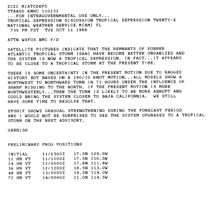
- ↑ a b Tropical Storm Isaac Preliminary Report (Page 1) ( English , GIF) National Hurricane Center. 1988. Retrieved June 4, 2008.
- ^ Tropical Depression Twenty-E Discussion for 0300 UTC ( English , GIF) National Hurricane Center. October 11, 1988. Retrieved October 21, 2007.
- ^ National Hurricane Center: Hurricane Joan Preliminary Report (Page 7) ( English , GIF) 1988. Retrieved June 4, 2008.
- ↑ a b National Hurricane Center: Hurricane Joan Preliminary Report (Page 2) ( English , GIF) 1988. Retrieved June 4, 2008.
- ↑ National Hurricane Center: Tropical Cyclone Report: Hurricane Ivan ( English ) 2005. Retrieved on 4 June of 2008.
- ^ National Hurricane Center: Hurricane Joan Preliminary Report (Page 3) ( English , GIF) 1988. Retrieved June 4, 2008.
- ^ National Hurricane Center: Hurricane Joan Preliminary Report (Page 1) ( English , GIF) 1988. Retrieved June 4, 2008.
- ↑ NOAA: FAQ Part E: Tropical Cyclone Records (Page 1) ( English ) 2007. Accessed June 4, 2008.
- ^ National Hurricane Center: Tropical Storm Keith Preliminary Report (Page 1) ( English ) 1988. Retrieved May 29, 2008.
- ^ National Hurricane Center: Tropical Storm Keith Preliminary Report (Page 2) ( English ) 1988. Retrieved May 29, 2008.
- ↑ Patrick Reyna: Late-Season Storm Forms; Cuba, Florida Likely Targets (English) , Associated Press. November 20, 1988.
- ^ Brian Murphy: Storm Keith Hovers In Gulf, Could Strike Florida , Associated Press. November 22, 1988.
- ↑ a b National Hurricane Center: Tropical Storm Keith Preliminary Report (Page 3) ( English ) 1988. Retrieved May 29, 2008.
- ^ The Globe and Mail : Tropical storm Keith hits Yucatan, western Cuba (English) . November 22, 1988.
- ↑ Thomas C. Tobin: Damage from Keith won't qualify for aid (English) , Saint Petersburg Times. December 7, 1988.
- ↑ Atlantic Oceanographic and Meteorological Laboratory: Hurricane Database (HURDAT) ( English ) 2006. Retrieved on 30 May, 2008.
- ^ Atlantic Oceanographic and Meteorological Laboratory: Subject: E11) How many tropical cyclones have there been each year in the Atlantic basin? ( English ) 2006. Retrieved May 30, 2008.
- ^ Climate Prediction Center: Background Information: The North Atlantic Hurricane Season . 2006. Archived from the original on November 15, 2010. Info: The archive link was inserted automatically and has not yet been checked. Please check the original and archive link according to the instructions and then remove this notice. Retrieved May 30, 2008.

1492-1600 | 1601-1700 | 1701-1799 | 1800s | 1810s | 1820s | 1830s | 1840s | 1850s | 1860s | 1870s | 1880-1884 | 1885 | 1886 | 1887 | 1888 | 1889 | 1890 | 1891 | 1892 | 1893 | 1894 | 1895 | 1896 | 1897 | 1898 | 1899 | 1915 | 1916 | 1917 | 1918 | 1919 | 1928 | 1929 | 1930 | 1931 | 1932 | 1933 | 1934 | 1935 | 1950 | 1951 | 1952 | 1953 | 1954 | 1955 | 1956 | 1957 | 1958 | 1959 | 1960 | 1961 | 1969 | 1970 | 1971 | 1972 | 1973 | 1974 | 1975 | 1976 | 1977 | 1978 | 1979 | 1980 | 1981 | 1982 | 1983 | 1984 | 1985 | 1986 | 1987 | 1988 | 1989 | 1990 | 1991 | 1992 | 1993 | 1994 | 1995 | 1996 | 1997 | 1998 | 1999 | 2000 | 2001 | 2002 | 2003 | 2004 | 2005 | 2006 | 2007 | 2008 | 2009 | 2010 | 2011 | 2012 | 2013 | 2014 | 2015 | 2016 | 2017 | 2018 | 2019 | 2020 | 2021