Atlantic hurricane season 1995
All the storms of the season
|
Formation of the
first storm |
2th of June |
Dissolution of the
last storm |
November 3rd |
| Strongest storm |
Opal - 916 hPa ( mbar ), 130 kn (240 km / h ) |
| Storms |
19th |
| Hurricanes |
11 |
| Severe hurricanes ( Cat. 3+ ) |
5 |
| Total number of victims |
138 direct, 20 indirect |
| Total damage |
$ 10.2 billion (1995) |
Atlantic hurricane seasons
1993 , 1994 , 1995 , 1996 , 1997
|
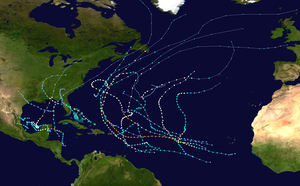
The 1995 Atlantic hurricane season was the third most active hurricane season in the Atlantic Ocean since reliable records began in 1851 , after the 2005 and 1933 Atlantic hurricane seasons. It officially began on June 1, 1995 and lasted until November 30, 1995. These dates conventionally limited the time period for each Year in which the most tropical cyclones form. The 1995 season was very active, mainly because of the favorable conditions. Nineteen named storms formed during the season, eleven of which reached hurricane strength. The most notable storms were Luis, Marilyn, and Opal .
Storms
Hurricane Allison
| Category 1 hurricane
|
|
|
| Duration
|
June 2nd - June 6th
|
| intensity
|
65 kn (120 km / h ) (1 minute) , 987 hPa
|
Allison was formed from a tropical depression that emerged on June 2nd southeast of Cuba . The following day, the low pressure area moved northwest and intensified into a tropical storm, which was named Allison and caused constant rain and gusty winds on the island. Despite strong winds at high altitude, the storm intensified into a category one hurricane on June 4th. Before making landfall 22 miles east of Carrabelle Beach in Franklin County on June 5, Allison weakened to a tropical storm. In the days that followed, Allison moved inland and became an extra-tropical low. The storm brought gusty winds and heavy rains on the US east coast before moving on towards Nova Scotia and finally disappearing completely west of Greenland .
Although Allison weakened to a tropical storm before landed in Florida , the storm brought a storm surge of 1.8–2.5 meters and rainfall of up to 150 mm. At least 60 homes and businesses were damaged by the storm and several streets were flooded. A total of four tornadoes raged in Florida, one of which was rated F1 on the Fujita scale . The damage totaled $ 860,000. In Georgia , there were several tornadoes and heavy rains that triggered minor flooding. There was damage of $ 800,000.
Tropical storm Barry
| Tropical storm
|
|
|
| Duration
|
July 5th - July 10th
|
| intensity
|
60 kn (110 km / h ) (1 minute) , 990 hPa
|
On July 5, the National Hurricane Center observed a very weak low pressure area that had an air pressure of 1019 hPa and was located between South Carolina and Bermuda . The following day it organized itself more and more, so that the National Hurricane Center declared the low pressure area to be tropical low pressure area two. On July 7th, the tropical depression off the coast of South Carolina intensified into a tropical storm and was named Barry. The storm headed north, making landfall on the eastern tip of Nova Scotia on July 9th , before going extra-tropical on July 10th.
Barry brought heavy rains and moderate winds to the Atlantic provinces . Nova Scotia and Newfoundland were particularly hard hit . Wind speeds of 75 km / h were achieved in Fourchu, Nova Scotia. Most of the rainfall that Barry produced occurred over Nova Scotia. Here the precipitation reached its peak with 110 mm. Minor floods were reported after the heavy rainfall. After the storm became extra-tropical, it rained 65mm on the Labrador Peninsula .
Tropical storm Chantal
| Tropical storm
|
|
|
| Duration
|
July 12th - July 20th
|
| intensity
|
60 kn (110 km / h ) (1 minute) , 991 hPa
|
Chantal comes from a tropical wave that moved from the west coast of Africa across the Atlantic on July 5th . On July 12, this wave developed well and was then classified as Tropical Depression Three. The low pressure area intensified quickly in the Tropical Storm Chantal. Initially, Chantal was expected to move to the Bahamas . Therefore, storm warnings were initially issued. This did not happen, however, as Chantal made a sharp curve to the north and spared the Bahamas and the rest of the Caribbean . After the storm moved north, Chantal now threatened to move over Bermuda . That is why storm warnings were also issued here. These were lifted on July 18, however, as Chantal passed northwest of Bermuda. Early on July 17th, Chantal almost reached hurricane status. Later that day, however, the storm began to ease. On July 20, Chantal was declared extratropical after the storm affected American shipping companies.
Although Chantal stayed on the high seas, the storm brought heavy rainfall to Nova Scotia and Newfoundland . On the Burin Peninsula , 75 millimeters fell. Further west, in Nova Scotia, heavy rainfall has been reported with record levels of 122mm.
Tropical Storm Dean
| Tropical storm
|
|
|
| Duration
|
July 28th - August 2nd
|
| intensity
|
40 kn (75 km / h ) (1 minute) , 999 hPa
|
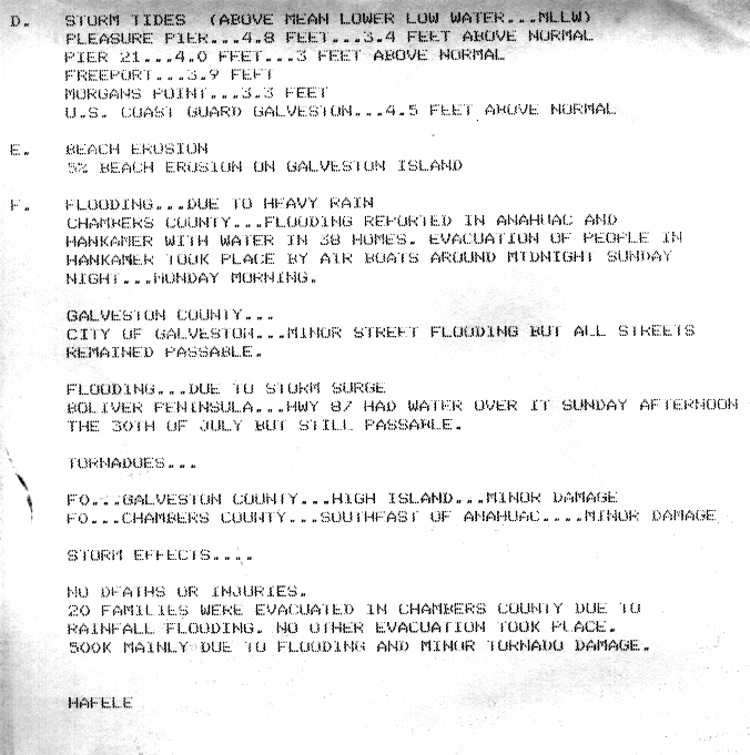
A stationary front in the Gulf of Mexico initially developed a circulation at height. By July 28 at 6:00 p.m. UTC, the system had organized itself sufficiently to be classified as Tropical Low Pressure Area Four, approximately 350 nautical miles southeast of New Orleans . Despite favorable conditions, the low pressure area migrated westward without intensifying significantly. After the system curved in a west-northwest direction, it began to gain strength and the system was declared a Tropical Storm on July 30th, just 110 km from the coast of Texas , and it was named Dean . After making landfall on July 31 near Freeport with sustained winds of 75 km / h and a central air pressure of 999 hPa, Dean weakened to a tropical low pressure area that continued to lose strength as it moved northwest until it disbanded on August 3 near the Texas- Oklahoma state line .
The storm surge caused minor flooding on the coast, particularly Galveston Island . Dean brought mostly light rainfall to Texas, although some areas recorded more than 200mm of rainfall; Monroe City reported the highest precipitation value with 426 mm. The rainfall caused mild to moderate damage locally and flooding caused 20 families to move out of their homes in Chambers County . 38 homes were flooded in southeast Texas. Two tornadoes were observed in connection with the storm and did not cause any significant damage. In Oklahoma , heavy rain caused more than 40 homes to flood and 24 vehicles got stuck in the flood. At least three highways were flooded, some side roads remained impassable for several days. Outside Oklahoma and Texas, the remnants of the storm caused rains in ten other states with no more than minor damage. Reported property losses were approximately $ 837 . One person was killed by the effects of the storm.
Hurricane Erin
| Category 2 hurricane
|
|
|
| Duration
|
July 31st - August 6th
|
| intensity
|
85 kn (155 km / h ) (1 minute) , 973 hPa
|
On July 22nd, a tropical wave left the west coast of Africa and slowly moved to the Lesser Antilles , where the system began to intensify. On July 31, it intensified into Tropical Storm Erin when it was west of the Turks and Caicos Islands . Despite increasing wind shear, the storm turned into a hurricane on the same day as it moved northwest. The next day, Erin experienced a further intensification and went ashore with winds of 140 km / h in Vero Beach , Indian River County , Florida . The storm quickly weakened overland to a tropical storm before moving into the warm Gulf of Mexico and intensifying again into a hurricane. On August 3, Erin had strengthened enough to be classified as a category two hurricane with winds of 155 km / h. With this intensity, the hurricane makes its second shore leave over Pensacola Beach and then weakens quickly. Over the next few days, Erin moves across the southern United States to the Midwest until it is merged with a frontal system over West Virginia on August 6th .
Erin was the first hurricane since Hurricane Andrew to land in the United States. In Jamaica , Erin's outer rainbands triggered heavy rains, causing a plane to crash. Five people died. Two other deaths occurred when two people were struck by lightning. Although strong winds and heavy rains were expected in the Bahamas , the damage there in connection with Erin was mostly minor. Nine people drowned on the Florida coast, three of them from the sinking of a cruise ship. Overland, high winds from Erin damaged at least 2,000 homes, most of them in the Florida Panhandle . In addition, the storm caused a power outage that affected a million people. Several tornadoes caused some damage. More than 100 homes were also damaged in Alabama . Between 50 and 75 percent of Baldwin County's crops were lost. Similar damage also occurred in Mississippi , albeit minor. Some areas were hit by the heavy rain caused by Erin. A total of 13 deaths and $ 700 million damage are reported.
Tropical Depression Six
| Tropical depression
|
|
|
| Duration
|
August 5th - August 7th
|
| intensity
|
30 kn (55 km / h ) (1 minute) , 1002 hPa
|
The southern part of the tropical wave that formed Erin continued into the Caribbean in late July. On August 4th, the system lay in Campeche Bay and developed into Tropical Depression Six by the next day. The depression gradually moved towards Mexico on the same day and continued to intensify. According to satellite images, the intensity remained just below that of a tropical storm. Later on August 6, the low pressure area in Veracruz went ashore and dissolved the next day.
Hurricane Felix
| Category 4 hurricane
|
|
|
| Duration
|
August 8 - August 22
|
| intensity
|
120 kn (220 km / h ) (1 minute) , 929 hPa
|
Tropical storm Gabrielle
| Tropical storm
|
|
|
| Duration
|
August 9th - August 12th
|
| intensity
|
60 kn (110 km / h ) (1 minute) , 988 hPa
|
Hurricane Humberto
| Category 2 hurricane
|
|
|
| Duration
|
August 22nd - September 1st
|
| intensity
|
95 kn (175 km / h ) (1 minute) , 968 hPa
|
Hurricane Iris
| Category 2 hurricane
|
|
|
| Duration
|
August 22nd - September 4th
|
| intensity
|
95 kn (175 km / h ) (1 minute) , 965 hPa
|
Tropical storm Jerry
| Tropical storm
|
|
|
| Duration
|
August 23 - August 28
|
| intensity
|
35 kn (65 km / h ) (1 minute) , 1002 hPa
|
Tropical storm Karen
| Tropical storm
|
|
|
| Duration
|
August 26th - September 3rd
|
| intensity
|
45 kn (85 km / h ) (1 minute) , 1000 hPa
|
Hurricane Luis
| Category 4 hurricane
|
|
|
| Duration
|
August 27th - September 11th
|
| intensity
|
120 kn (220 km / h ) (1 minute) , 935 hPa
|
Tropical Depression Fourteen
| Tropical depression
|
|
|
| Duration
|
September 9th - September 13th
|
| intensity
|
30 kn (55 km / h ) (1 minute) , 1008 hPa
|
Hurricane Marilyn
| Category 3 hurricane
|
|
|
| Duration
|
September 12th - September 22nd
|
| intensity
|
100 kn (185 km / h ) (1 minute) , 949 hPa
|
Hurricane Noel
| Category 1 hurricane
|
|
|
| Duration
|
September 26th - October 7th
|
| intensity
|
65 kn (120 km / h ) (1 minute) , 987 hPa
|
Hurricane Opal
| Category 4 hurricane
|
|
|
| Duration
|
September 27th - October 5th
|
| intensity
|
130 kn (240 km / h ) (1 minute) , 916 hPa
|
Tropical storm Pablo
| Tropical storm
|
|
|
| Duration
|
October 4th - October 8th
|
| intensity
|
50 kn (95 km / h ) (1 minute) , 994 hPa
|
Hurricane Roxanne
| Category 3 hurricane
|
|
|
| Duration
|
October 7th - October 21st
|
| intensity
|
100 kn (185 km / h ) (1 minute) , 956 hPa
|
Tropical storm Sebastien
| Tropical storm
|
|
|
| Duration
|
October 20th - October 25th
|
| intensity
|
55 kn (100 km / h ) (1 minute) , 1001 hPa
|
Hurricane Tanya
| Category 1 hurricane
|
|
|
| Duration
|
October 27th - November 1st
|
| intensity
|
75 kn (140 km / h ) (1 minute) , 972 hPa
|
Season overview
Web links
Individual evidence
-
^ Richard Pasch: Hurricane Allison Preliminary Report ( English ) National Hurricane Center. January 29, 1996. Retrieved October 7, 2010.
-
^ Max Mayfield: Tropical Storm Barry Preliminary Report ( English ) National Hurricane Center. November 19, 1995. Retrieved October 7, 2010.
-
^ Miles Lawrence: Tropical Storm Chantal Preliminary Report ( English ) National Hurricane Center. November 17, 1995. Retrieved October 7, 2010.
-
^ A b Lixion Avila: Tropical Storm Dean Preliminary Report ( English ) National Hurricane Center. November 14, 1995. Archived from the original on September 2, 2010. Retrieved October 31, 2014.
-
^ A b NWS Houston / Galveston: Summary of Tropical Storm Dean ( English , GIF) National Oceanic and Atmospheric Administration. 1995. Retrieved October 31, 2014.
-
↑ a b David M. Roth: Tropical Storm Dean - July 28-August 4, 1995 ( English ) Hydrometeorological Prediction Center . January 18, 2007. Retrieved October 31, 2014.
-
^ A b Gene Hafele: Final Storm Report ... Tropical Storm Dean ( English , GIF) National Oceanic and Atmospheric Administration. August 4, 1995. Retrieved October 31, 2014.
-
↑ a b August 1995 Storm Data ( English ) In: National Weather Service . National Oceanic and Atmospheric Administration. August 1995. Archived from the original on October 8, 2006. Retrieved November 29, 2008.
-
^ Edward Rappaport: Hurricane Erin Preliminary Report ( English ) National Hurricane Center. November 26, 1995. Retrieved October 9, 2012.
-
^ Richard Pasch: Tropical Depression Six Preliminary Report ( English ) National Hurricane Center. January 10, 1996. Retrieved October 9, 2012.


.gif)


.JPG)

.gif)


_color.jpg)


.gif)


.JPG)


