
1983 Atlantic hurricane season
 All the storms of the season | |
| Formation of the first storm |
29th of July |
|---|---|
| Dissolution of the last storm |
30. September |
| Strongest storm | Alicia - 963 hPa ( mbar ), 100 kn (185 km / h ) |
| Tropical lows | 7th |
| Storms | 4th |
| Hurricanes | 3 |
| Severe hurricanes ( Cat. 3+ ) | 1 |
| Total number of victims | 22nd |
| Total damage | $ 2.6 billion (1983) |
|
Atlantic hurricane seasons 1981 , 1982 , 1983 , 1984 , 1985 | |
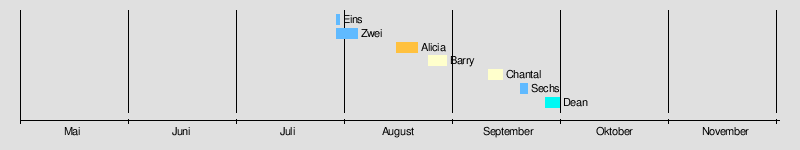
The 1983 Atlantic hurricane season officially began on June 1, 1983 and lasted through November 30. These dates usually limit the period of the year in which most tropical cyclones form in the Atlantic Ocean . It was the least active hurricane season in the Atlantic Basin since recording began in 1950.
In total, only seven tropical low pressure areas formed, four of which reached at least the strength of a tropical storm. The Accumulated Cyclone Energy is the lowest since this rating was introduced in 1950.
The season started later than usual, with the first tropical depression not forming until July 29; the second followed just two days later. Neither of them could intensify. Hurricane Alicia formed the third low pressure system of the season on August 15, intensified into a hurricane the next day, and hit the Texas coast on August 18 , where the storm caused $ 2.6 billion in property damage. Hurricane Barry formed on August 25th, crossed Florida and intensified into a hurricane. Barry broke up on August 30th after making landfall at Brownsville .
Hurricane Chantal, the third and final hurricane of the year, formed on September 10, but remained far at sea, where it was absorbed by a system of fronts on September 15. Tropical Depression Six formed on September 19, causing heavy rainfall on the Caribbean islands before degenerating into a tropical wave on September 21 . Dean formed on September 26th and moved north as a tropical storm. It moved across the Delmarva Peninsula on September 29 and its breakup over the coast of Virginia ended the season of little activity.
Season forecast and actual activity
| source | date |
Named storms |
Hurricanes |
Severe hurricanes |
| CSU | July 23 | 8th | 5 | not known |
| Highest activity | 28 | 15th | 8th | |
| Lowest activity | 1 | 0 | 0 | |
| Actual activity | 4th | 3 | 1 | |
A forecast of cyclone activity was made at the time by hurricane experts such as William M. Gray and his team at Colorado State University . A normal season, as defined by NOAA, has six to fourteen named storms, four to eight of which become hurricanes, with one to three hurricanes becoming so-called severe hurricanes, meaning they reach at least Category 3 on the Saffir Simpson hurricane wind scale . The forecast, published on July 23, 1983, assumed after the slow start of the season that a total of eight storms would form, five of which would reach hurricane status. The forecast did not specify how many of the hurricanes would reach Category 3 or higher. That forecast proved too high, as only four named storms had formed by the end of the season, including three hurricanes.
The season was very inactive due to strong wind shear at high altitude. The wind shear was unusually strong, especially in the Caribbean and on the open Atlantic, so that in areas with a weather disturbance the formation of convection was prevented so that no low pressure areas could develop. Over sixty systems formed on the coast of Africa and moved west across the Atlantic, but once they reached the Leeward Islands they easily disintegrated. The only area where wind shear was low - formed by the Gulf of Mexico and the Atlantic Ocean north of the Bahamas and east of Florida - was the origin of the season's four named storms. The 1983 Atlantic hurricane season was the least active season since the 1930 Atlantic hurricane season , in which only two storms occurred. 1982 and 1983 are the only two consecutive years since the beginning of systematic hurricane observations in 1871, in which no hurricanes formed in the Caribbean Sea . 1983 was also the first time since 1871 that no storm south of 25 ° north latitude formed.
1983 was the first season for the National Hurricane Center to announce numerical landfall probabilities. Such probabilities have previously been calculated to be used in individual storm warnings, but these figures have not previously been published. The probabilities given during Alicia's existence were correct and indicated that Galveston and the surrounding area would be most likely to be hit by the storm.
Storms
Tropical Depression One
| Tropical depression | |||
|---|---|---|---|
|
|||
| Duration | July 29th - July 30th | ||
| intensity | 30 kn (55 km / h ) (1 minute) | ||
.jpg)
Tropical Depression One formed on July 29 from a tropical disturbance near the Leeward Islands . The National Hurricane Center indicated the possibility of intensification into a tropical storm, but wind shear at high altitude prevented any development. The next day the system dissolved.
Tropical Depression Two
| Tropical depression | |||
|---|---|---|---|
|
|||
| Duration | July 31st - August 3rd | ||
| intensity | 25 kn (45 km / h ) (1 minute) | ||

A disturbed weather area in the mid Atlantic managed to develop enough organization to be classified as Tropical Depression Two on July 31. The low moved across the Atlantic without strengthening, as it was exposed to strong wind shear at high altitude, and dissolved near the Lesser Antilles on August 3rd.
Hurricane Alicia
| Category 3 hurricane | |||
|---|---|---|---|
|
|||
| Duration | August 15 - August 20 | ||
| intensity | 100 kn (185 km / h ) (1 minute) , 963 hPa | ||


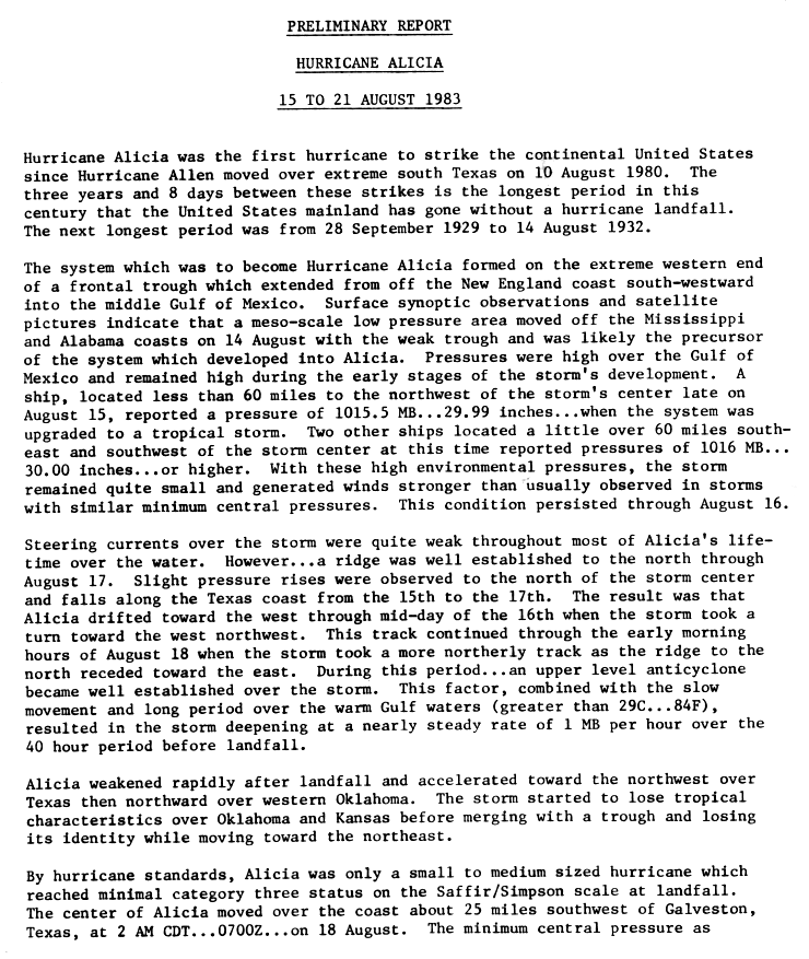
The system that developed into Hurricane Alicia originated at the western end of a frontal trough that stretched from New England to the Gulf of Mexico . Satellite imagery showed a sub-low pressure area that moved near the trough off the coast of Alabama and Mississippi , possibly a precursor system of Alicia. The air pressure in the Gulf of Mexico was high and remained so in the early stages of the hurricane development. On August 15, a ship measured an air pressure of 1015 mbar (hPa) just as the system was upgraded to Tropical Storm Alicia. With high pressure in the area, Alicia remained a small system.
The steering currents above Alicia remained weak throughout the life of the storm, but a ridge formed well north of the developing storm. With fluctuations in air pressure, the storm began on August 16 with a westerly drift. This did not last long as Alicia turned on a northwest course towards Texas . In the period between August 16 and 18, an anticyclone had formed over Alicia and, together with the slow forward movement over warm waters, this led to a rapid intensification. The air pressure in the center of Alicia dropped one millibar every hour in the 40 hours before landfall . Alicia reached its greatest strength on August 18 with a sustained wind speed of 185 km / h and 962 mbar (hPa) and reached Galveston on the same day as a Category 3 hurricane over land. There Alicia weakened quickly and accelerated forward over the Midwest before dispersing over Nebraska on August 21 .
As Alicia hiked north, the humidity of the residual low caused heavy rains in several states. Houston recorded severe damage, including thousands of window panes on the high-rise buildings in the center of the city. In all, Alicia killed twenty-two people and resulted in $ 2.6 billion property damage (1983).
Hurricane Barry
| Category 1 hurricane | |||
|---|---|---|---|
|
|||
| Duration | August 23 - August 29 | ||
| intensity | 70 kn (130 km / h ) (1 minute) , 986 hPa | ||


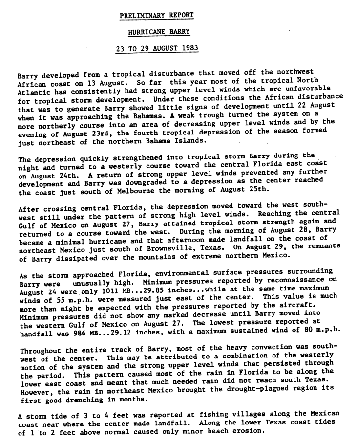
Hurricane Barry originated from a tropical disturbance that broke off the northwest coast of Africa on August 13th . For most of the hurricane season, the northwest tropical Atlantic was affected by high altitude wind shear , thereby hampering the development of tropical systems. Due to these conditions, the disturbance could not intensify until the approach to the Bahamas on August 22nd. A weak trough pushed the fault into an area with little shear and the fault was able to develop into Tropical Depression Four on the evening of August 23. The low was just northeast of the northern islands of the Bahamas when it intensified into a tropical storm on the morning of August 24th.
As a tropical storm, Barry turned west and when the wind shear increased again, Barry weakened to the low pressure area. The depression hit the mainland near Melbourne on the morning of August 25th. After the system moved to the eastern Gulf of Mexico , it was still pressurized by high-altitude winds. Only in the middle of the gulf did Barry regain storm strength. Barry intensified rapidly and became a hurricane on August 28th. Before the landfall near Brownsville on the afternoon of that day , Barry reached its peak with sustained wind speeds of 130 km / h and a minimum central air pressure of 986 mbar (hPa). The remnants of the hurricane, which abated rapidly overland, dispersed over the mountains of northern Mexico on August 29 .
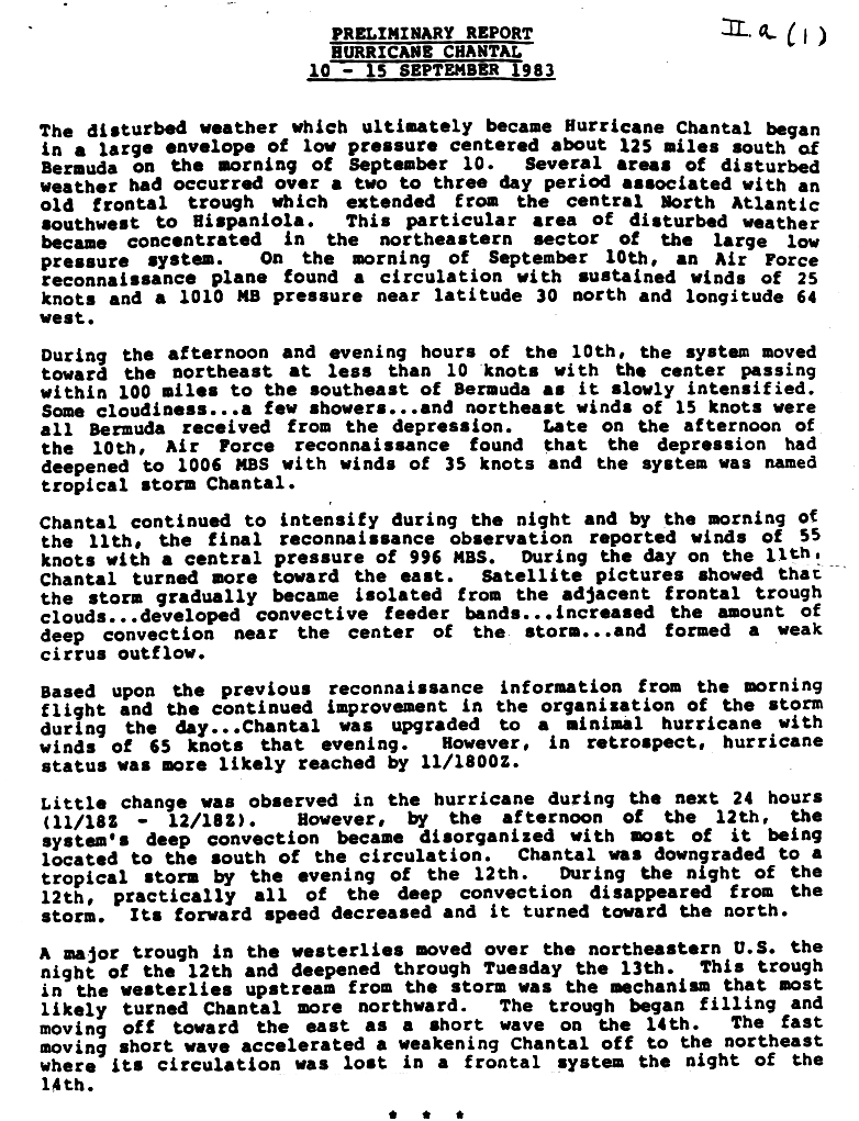
Hurricane Chantal
| Category 1 hurricane | |||
|---|---|---|---|
|
|||
| Duration | September 10th - September 15th | ||
| intensity | 65 kn (120 km / h ) (1 minute) , 994 hPa | ||
.JPG)

The weather disruption that would soon become Chantal originated on the morning of September 10th in a vast depression. The fault, embedded in the deep off the coast of Bermuda , was a remnant of an old frontal trough that had stretched from Hispaniola to the central North Atlantic. The weather disturbance became the northeastern part of a low pressure system. On September 10, a reconnaissance aircraft detected constant winds of 50 km / h and a minimum air pressure of 1010 mbar (hPa). Based on these measurements, the low pressure system was classified as the fifth tropical low pressure area of the 1983 season.
The low pressure area migrated up to 160 km to Bermuda and slowly intensified. In the late afternoon, the storm had reached wind speeds of 60 km / h and was named Chantal. Chantal intensified rapidly and reached 105 km / h on the morning of September 11th. Chantal turned to the east and managed to form a weak discharge with cirrus clouds . On the morning of September 22nd, Chantal was classified as a hurricane, but the post-analysis showed that the storm could have reached this strength the night before. The hurricane changed little over the next few hours, but the following night the system lost its organization and was downgraded to a tropical storm.
Overnight the convection from Chantal completely dissolved and the northward forward speed decreased. A weak wave then pushed Chantal forward and the system merged into a front system on the evening of September 14th. The impact on Bermuda was minimal; the wind reached around 25 km / h and some thunderstorms were falling. Chantal resulted in swell of 9 to 12 m on the east coast of the United States .
Tropical Depression Six
| Tropical depression | |||
|---|---|---|---|
|
|||
| Duration | September 19 - September 21 | ||
| intensity | 30 kn (55 km / h ) (1 minute) | ||

Tropical Depression Six formed on September 19th. It caused heavy rainfall on the Leeward Islands before turning into a tropical wave near the Dominican Republic on September 21 .
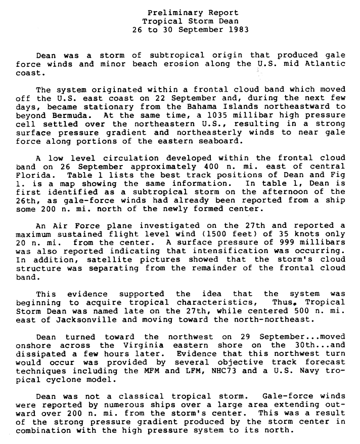
Tropical Storm Dean
| Tropical storm | |||
|---|---|---|---|
|
|||
| Duration | September 26th - September 30th | ||
| intensity | 55 kn (100 km / h ) (1 minute) , 999 hPa | ||
.JPG)

Tropical Storm Dean originated from a frontal band of clouds that moved off the east coast of the United States on September 22nd . Over the next few days, the band of clouds from the Bahamas to beyond Bermuda became nearly stationary. During this time, a high pressure cell at 1035 mbar (hPa) had settled over the northeastern United States . This led to a strong pressure gradient and winds that almost reached storm strength along the Atlantic coast .
A near-surface circulation formed on September 26th from the frontal cloud band, about 740 km east of central Florida . Dean was first recognized as a subtropical storm on the afternoon of September 26th . A United States Air Force reconnaissance aircraft was dispatched to Dean on September 27th. It detected wind speeds of only 55 km / h about 37 km from the storm center. An air pressure of 999 mbar (hPa) indicated that Dean intensified on his move north. The satellite images showed that the subtropical storm broke away from the cloud mass. The data also indicated that the storm was taking on tropical characteristics, and on the afternoon of September 27th, the NHC classified the storm as a tropical storm.
Dean's winds peaked at 80 km / h on September 28th, when the storm was moving northwards. Dean's circulation turned northwest on September 29th and, with its landfall on the Delmarva Peninsula, was one of three storms in recorded history to do so, previously tropical storms Bret 1981 and Danielle 1992. Dean broke up on September 30th. September overland.
Storm warnings have been issued because of Dean on the coast between North Carolina and Rhode Island . Dean led to heavy rain from the North Carolina / Virginia state line to New England . Virginia reported between 25 and 76 mm of rain. The highest amount of rain was measured at 117 mm at the Cockaponset Ranger Station in Connecticut . Damage from the tropical storm was limited to coastal erosion and flooding in the states on the central section of the US Atlantic coast.
Season overview
Accumulated Cyclone Energy (ACE)
| ACE (10 4 kt 2 ) - storm | |||||||||||
|---|---|---|---|---|---|---|---|---|---|---|---|
| 1 | 6.38 | Alicia | 2 | 4.27 | Chantal | ||||||
| 3 | 3.14 | Barry | 4th | 3.07 | dean | ||||||
| Total = 16.9 (16.86) | |||||||||||
The table opposite shows the ACE for every storm this year. The ACE describes the energy of a tropical storm by multiplying the strength of a storm with the duration, i.e. long-lasting storms as well as strong storms have a high ACE value. Traditionally, the NOAA only records storms with wind speeds of over 34 knots (63 km / h).
The 1983 season had an ACE of 16.9 (16.86), which is well below average and the lowest since the 1914 Atlantic hurricane season , which had an ACE of 2.53.
Storm names
The following names have been used to denote storms. With the exception of Alicia, these names were reused in the 1989 Atlantic hurricane season . This list of names was first used in 1983 because the National Hurricane Center had drawn up new lists of names after the 1978 season.
|
|
|
The World Meteorological Organization removed the name Alicia from this list in the spring of 1984 . Because of this, Alicia was replaced by Allison from 1989.
Individual evidence
- ^ John Arnold: Hurricane season ends weakly ( English ) November 30, 1983. Retrieved December 16, 2007.
- ↑ a b c d e f g h i Robert Case and Harold Gerrish: 1983 Monthly Weather Review ( English , PDF; 968 kB) American Meteorological Society. 1984. Retrieved November 22, 2008.
- ↑ a b Mary Vorobril: Five hurricane season predicted. New – though fallible – technique also forecasts a busy 1984 period (English) . In: The Miami Herald , July 23, 1983, p. 3A. Retrieved November 22, 2008.
- ^ National Hurricane Center: Hurricane Alicia Preliminary Report Page 3 ( English , GIF) National Hurricane Center. 1983. Retrieved November 22, 2008.
- ↑ Liz Balmaseda: 2 DAYS OF RAIN CAUSE A DIP IN TEMPERATURES (English) (PDF). In: The Miami Herald , July 29, 1983. Retrieved November 22, 2008.
- ↑ Associated Press: Forecast: 90s, humid, but rest of US will be hotter (English) (PDF), The Hurricane archives. July 29, 1983. Archived from the original on May 23, 2016 Info: The archive link was inserted automatically and has not yet been checked. Please check the original and archive link according to the instructions and then remove this notice. . Retrieved November 22, 2008.
- ↑ Liz Balmaseda: Depression has good chance of being first tropical storm (English) . In: The Miami Herald . Retrieved November 22, 2008.
- ↑ Miami Herald: 2nd tropical depression withers (English) . In: The Miami Herald . Retrieved November 22, 2008.
- ↑ a b c National Hurricane Center: Hurricane Alicia Preliminary Report Page 1 ( English , GIF) National Hurricane Center. 1983. Retrieved November 22, 2008.
- ^ A b David Roth: Tropical Cyclone Rainfall: Hurricane Alicia ( English ) Hydrometeorological Prediction Center. 2007. Archived from the original on February 8, 2013. Info: The archive link has been inserted automatically and has not yet been checked. Please check the original and archive link according to the instructions and then remove this notice. Retrieved November 22, 2008.
- ↑ Daily Herald: Alicia Mauls Texas; 6 die ( English ) 1983-08-19. Archived from the original on January 13, 2016. Info: The archive link was inserted automatically and has not yet been checked. Please check the original and archive link according to the instructions and then remove this notice. Retrieved November 22, 2008.
- ↑ Bruce Nichols: Alicia's death toll low, damage high ( English ) 1983-08-19. Archived from the original on May 26, 2016. Info: The archive link was inserted automatically and has not yet been checked. Please check the original and archive link according to the instructions and then remove this notice. Retrieved February 5, 2007.
- ↑ a b c National Hurricane Center: Hurricane Barry Preliminary Report ( English , GIF) National Hurricane Center. 1983. Retrieved December 23, 2007.
- ↑ a b c d National Hurricane Center: Hurricane Chantal Preliminary Report ( English , GIF) National Hurricane Center. 1983. Retrieved November 22, 2008.
- ↑ Philadelphia Inquirer: Hurricane Chantal Bypasses Bermuda (English) (PDF). In: The Philadelphia Inquirer , September 12, 1983. Retrieved February 3, 2007.
- ↑ Miami Herald: New Tropical Depression Forms. Aims Toward Windwards (English) . In: The Miami Herald . Retrieved November 22, 2008.
- ↑ Miami Herald: Caribbean Storm Downgraded (English) . In: The Miami Herald . Retrieved November 22, 2008.
- ^ A b c d e Miles B. Lawrence: Tropical Storm Dean Preliminary Report ( English , GIF) National Hurricane Center. October 14, 1983. Retrieved November 22, 2008.
- ^ Miles B. Lawrence: Tropical Storm Dean Preliminary Report - Page 2 ( English , GIF) National Hurricane Center. October 14, 1983. Retrieved December 21, 2007.
- ^ A b David Roth: Tropical Cyclone Rainfall: Tropical Storm Dean ( English ) Hydrometeorological Prediction Center. 2007. Archived from the original on December 22nd, 2014. Info: The archive link was inserted automatically and has not yet been checked. Please check the original and archive link according to the instructions and then remove this notice. Retrieved November 22, 2008.
- ^ A b NOAA: Atlantic Hurricane Database . NOAA. 2007. Retrieved November 22, 2008.
literature
- Henry F. Diaz, Markgraf, Vera: El Niño and the Southern Oscillation: Multiscale Variability and Global . Cambridge University Press, Cambridge 2000, ISBN 0521621380 .
- David R. Godschalk, Brower, David J .; Beatley, Timothy: Catastrophic Coastal Storms: Hazard Mitigation and Development . Duke University Press, Durham 1989, ISBN 082230855X .
Web links
- Detailed information on all storms from 1983 from NHC
- US Rainfall information for storms from 1983 from HPC ( Memento from February 8, 2013 in the Internet Archive )

1492-1600 | 1601-1700 | 1701-1799 | 1800s | 1810s | 1820s | 1830s | 1840s | 1850s | 1860s | 1870s | 1880-1884 | 1885 | 1886 | 1887 | 1888 | 1889 | 1890 | 1891 | 1892 | 1893 | 1894 | 1895 | 1896 | 1897 | 1898 | 1899 | 1915 | 1916 | 1917 | 1918 | 1919 | 1928 | 1929 | 1930 | 1931 | 1932 | 1933 | 1934 | 1935 | 1950 | 1951 | 1952 | 1953 | 1954 | 1955 | 1956 | 1957 | 1958 | 1959 | 1960 | 1961 | 1969 | 1970 | 1971 | 1972 | 1973 | 1974 | 1975 | 1976 | 1977 | 1978 | 1979 | 1980 | 1981 | 1982 | 1983 | 1984 | 1985 | 1986 | 1987 | 1988 | 1989 | 1990 | 1991 | 1992 | 1993 | 1994 | 1995 | 1996 | 1997 | 1998 | 1999 | 2000 | 2001 | 2002 | 2003 | 2004 | 2005 | 2006 | 2007 | 2008 | 2009 | 2010 | 2011 | 2012 | 2013 | 2014 | 2015 | 2016 | 2017 | 2018 | 2019 | 2020 | 2021