Ilhéu de Cima (Cape Verde)
| Ilheu de Cima | ||
|---|---|---|
| Ilheu de Cima | ||
| Waters | Atlantic Ocean | |
| Archipelago | Ilhéus do Rombo | |
| Geographical location | 14 ° 58 ′ 16 ″ N , 24 ° 38 ′ 15 ″ W | |
|
|
||
| length | 2.2 km | |
| width | 940 m | |
| surface | 1.5 km² | |
| Residents | uninhabited | |
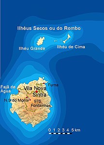
| Ilhéu de Cima (top right) | ||
Ilhéu de Cima is an island of the Ilhéus do Rombo , an archipelago in the southwest of the Cape Verde Islands . The islands are uninhabited and are under nature protection .
geography
The almost vegetation-free islet is the second largest island of the Ilhéus do Rombo. This group of islands is located around seven kilometers northeast of the island of Brava . Four kilometers west of Ilhéu de Cima is Ilhéu Grande , the largest and westernmost island of the Ilhéus do Rombo. The islands of Ilhéu Luíz Carneiro, Ilhéu Sapado and Ilhéu do Rei are only a few hundred meters in diameter. There are also some other smaller rocks rising out of the water. Overall, the area is very dangerous for shipping, which is why there is a lighthouse on the southern tip of Ilhéu de Cima at about 80 meters above sea level.


