Isola della Cappa
| Isola della Cappa | ||
|---|---|---|
| Isola della Cappa | ||
| Waters | Tyrrhenian Sea | |
| Archipelago | Tuscan Archipelago | |
| Geographical location | 42 ° 20 '58 " N , 10 ° 52' 57" E | |
|
|
||
| length | 80 m | |
| width | 40 m | |
| surface | 0.2 ha | |
| Highest elevation | 17 m slm | |
| Residents | uninhabited | |
| Map of the Tuscan Archipelago | ||
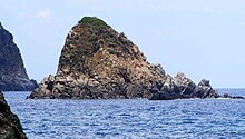
The Isola della Cappa (also Scoglio della Cappa ) is a rocky island 65 meters off the west coast of the island of Giglio in the Tuscan Archipelago , south of the small bay of Cala dell'Allume . The small island belongs to the municipality of Isola del Giglio . It measures 80 meters from north to south and is a maximum of 40 meters wide in the northern area. The area covers 0.2 hectares . The island is sparsely overgrown, only in the summit area there is denser vegetation ( garigue ).
The surroundings of the small island offer an interesting diving area .
Web links
Commons : Isola della Cappa - Collection of images, videos and audio files


