
Capraia
| Capraia | ||
|---|---|---|
 |
||
| Waters | Ligurian sea | |
| Archipelago | Tuscan Archipelago | |
| Geographical location | 43 ° 2 ′ 30 " N , 9 ° 48 ′ 30" E | |
|
||
| surface | 19 km² | |
| Highest elevation | Monte Castello 447 m asl |
|
| Residents | 405 (2017) 21 inhabitants / km² |
|
| main place | Capraia | |
 |
||

Capraia is an island in the Mediterranean Sea and belongs to the Tuscan Archipelago in the Tuscany region in Italy. The island forms the area of the municipality of Capraia Isola ( Province of Livorno ) with 405 inhabitants.
Location and dates

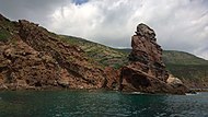
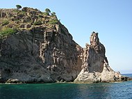
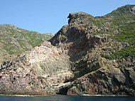
Capraia is located between the Cap Corse in northern Corsica and the Italian mainland. Geographically, Capraia is one of the Tyrrhenian Islands. Its origin goes back to several violent volcanic eruptions that occurred nine million years ago. The island, which is around 20 km² today, is characterized by rugged mountains, the highest mountain being Monte Castello at 447 m. The coastal strip is formed by a rugged cliff that is hardly interrupted by bays. The Cala Rossa is the remains of a crashed into the sea volcanic cone.
geology
Capraia is exclusively of volcanic origin and is counted either in the Corsican or the Tuscan Magma Province . Their predominantly calcareous magmas formed from the Tortonium - towards the end of the Miocene compression phase in the area of northern Tyrrhenis . This was preceded by the counterclockwise rotation of the Corsican microcontinent during the Burdigalium, as well as the ceiling stacking of the slowly emerging Apennine orogen in its eastern apron . The new crust expansion in the back arc area of the Apennine arch now made it possible for the accumulated magma to penetrate the fracture systems in the subsurface of Capraia. By means of overlapping lava, ash and block flows, as well as pyroclastic deposits, trodden at several extraction centers and lava domes , an asymmetrical stratovolcano built up - the Capraia volcano .
Petrologically, the lavas that are extracted consist of potassium-rich andesites , dazites and rhyolites , but can also change over to the TAS fields latite and trachyte . The mineralogical structure of volcanic rocks is generally porphyritic and is dominated by plagioclase pheocrystals, which are joined by clinopyroxene , orthopyroxene and biotite . Occasionally, olivine and amphibole also appear.
Two eruption phases can be distinguished on Capraia, which are separated from each other by a production pause lasting around 3 million years. In the first and much more significant phase, which lasted from 7.59 to 7.25 million years BP, the stratovolcano, which makes up most of the island, gradually grew over a submarine base rising several hundred meters above the surrounding seabed. This base area is presumably older and goes back possibly to 8.3, possibly also to 9.5 million years BP.
In the Zancleum around 4.6 million years BP, the Zenobito volcano emerged in the extreme south of the island with a predominantly Shoshonite and subordinate trachybasaltic and, more rarely, basaltandesitic composition. The Zenobito volcano is a small monogenic extraction center located on the Punto dello Zenobito . It once consisted of a subaeric ash cone, which in turn was covered by an alternation of thinner lava flows and scorial layers. However, the very strong sea erosion soon brought this volcanic center to collapse, so that today only the former extraction vent with the north side of the ash cone and its outer layers have been preserved.
Impressions

The Cala Rossa


.jpg)


history

The island was called Aegylon (Αηγυλον) by the Greeks and Capraria by the Romans - both names probably refer to the presence of wild goats on Capraia ( it. Capra = goat). Another theory assumes that the name is derived from the old Mediterranean root * karpa , meaning rock, stone .
In the Middle Ages, the island was initially a base for Saracen pirates, then it was under the rule of Pisa , after the Battle of Meloria it came to Genoa . Although Capraia was administratively part of Corsica , the island remained with Genoa after 1768 and did not come to France.
After the unification of Italy (see Risorgimento ), the island was part of the province of Genoa until November 15, 1925 , only then did it come to Tuscany . From the Second World War until 1986, the island was an agricultural penal colony.
Most of the island - everything except for the area of the main town and the port area with around 120 inhabitants - belongs to the Parco nazionale dell'Arcipelago Toscano National Park, founded in 1989 .
traffic
The island can be reached by ferries from Livorno :
- Car ferry of the shipping company Toremar all year round, crossing approx. 2.5 hours
- Fast passenger ferry of the shipping company Navigazione Golfo dei Poeti in the summer months, crossing approx. 1.5 hours
Web links
- Info about Capraia (Italian)
- News about Capraia (Italian)
Individual evidence
- ↑ ISTAT , Statistiche demografiche , as of December 31, 2017
- ↑ Aldighieri, B., Groppelli, G., Norini, G. and Testa, B .: Capraia Island: Morphology and Geology of a Complex Volcanic activity during the Miocene and Pliocene . In: Morini, D. and Bruni, P. (Eds.): The Regione Toscana project of Geological Mapping, case histories and data acquisition . 2004, p. 51-59 .