Itatinga
| Município de Itatinga "Presépio da serra"
Itatinga
|
|||
|---|---|---|---|
|
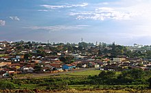
View over Itatinga
|
|||
|
|
|||
| Coordinates | 23 ° 6 ′ S , 48 ° 37 ′ W | ||
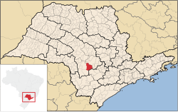
 Location of the municipality of Itatinga in the state of São Paulo Location of the municipality of Itatinga in the state of São Paulo
|
|||
| Symbols | |||
|
|||
| founding | July 24, 1896 | ||
| Basic data | |||
| Country | Brazil | ||
| State | São Paulo | ||
| ISO 3166-2 | BR-SP | ||
| height | 848 m | ||
| Waters | Rio Novo, Rio das Pedras, Rio Bonito, Rio Tamanduá, Rio Pardo, Rio Santo Inácio, Rio dos Veados, Ribeirão do Meio, Rio Paranapanema | ||
| climate | tropical, Aw | ||
| surface | 979.8 km² | ||
| Residents | 18,052 (2010) | ||
| density | 18.4 Ew. / km² | ||
| estimate | 20,467 (July 1, 2018) | ||
| Parish code | IBGE : 3523503 | ||
| Time zone | UTC −3 | ||
| Website | www.itatinga.sp.gov.br (Brazilian Portuguese) | ||
| politics | |||
| City Prefect | João Bosco Borges (2017-2020) | ||
| Political party | Democratas (DEM) | ||
| economy | |||
| GDP | 227,518 thousand R $ 11,527 R $ per person (2015) |
||
| HDI | 0.706 (2010) | ||
Itatinga , officially Portuguese Município de Itatinga , is a small town in São Paulo , Brazil . In 2010 there were 18,052 inhabitants. The township includes the core city of Itatinga, which was São João de Itatinga until 1938 , and the village of Lôbo .
geography
The municipality is located about 220 km west of the center of the state capital São Paulo . Your neighboring communities clockwise from the north are Botucatu , Pardinho , Bofete , Angatuba , Paranapanema and Avaré .
The municipality of Itatinga is around 980 km². The center of the village is at an altitude of approx. 845 meters. At its southern edge is the Jurumirim reservoir ( Represa de Jurumirim ). In the village of Lôbo there is a dam that dams the Rio Pardo to generate electricity. There are also other smaller rivers.
The mild and dry climate is subtropical, with an average annual temperature of 19.2 ° C.
history
The place name is derived from the Tupí-Guaraní language and means white stone . It refers to a natural monument east of the city center.
The village of Lôbo was laid out in 1875. The founding of today's core city took place in 1884 as São João de Itatinga , together with the construction of a chapel of St. John the Baptist. The municipality achieved its independence from the neighboring municipality of Avaré on July 24, 1896. The municipality name was shortened to Itatinga in 1938.
In 1914 a railway line was built through the town. This was a branch line Botucatu-Avaré of the Sorocaba Railway (Estrada de Ferro Sorocabana). In 1953, the railway line was expanded and electrified. The line was in operation until 1999.
In 1951, Cistercian monks from Germany settled in the village. They were expelled from Hardehausen Monastery by the National Socialists in 1938 . Under the direction of their abbot Alfons Heun, they built the monastery of the Assumption of Mary Hardehausen-Itatinga (Abadia de Nossa Senhora da Assunção).
politics
The place is located in the Administrative Region IV Sorocaba. From 1989 to 2017 it belonged to the Baruru mesoregion and there to the Avaré microregion .
In the local elections in 2012 , Paulo Marcos Borges dos Santos from the Green Party (PV) won 56.62% of the vote as city prefect for the 2013 to 2016 term. He was replaced by João Bosco Borges of the Democratas (DEM) in the local elections in 2016 for the 2017-2020 term.
population
The city's residents are predominantly of European descent. Most of the population (84%) lives in the core city. The Instituto Brasileiro de Geografia e Estatística (IBGE) estimated a new population for 2018 at 20,467.
| year | Residents |
|---|---|
| 1991 | 13,769 |
| 1996 | 13,791 |
| 2000 | 15,446 |
| 2007 | 17,570 |
| 2010 | 18,052 |
| 2018 | 20,467 |
Culture and sights
- Mother Church of St. John the Baptist
- Monastery of the Assumption of Mary
- House of Education and Culture
- Embankment of the Rio Pardo near Lôbo
Economy and Infrastructure
The place has the basic infrastructure facilities such as water, sewerage and electricity nationwide.
The state road SP-280 runs through the village and crosses the federal road BR-374 near the village .
In the neighboring town of Avaré is the small airport Aeroporto de Avaré-Arandu . However, this is not served by scheduled services.
Personalities who have worked on site
Web links
- Itatinga city. Prefeitura Municipal de Itatinga - SP, accessed August 6, 2013 .
- Itatinga. IBGE , accessed August 6, 2013 .
- Abadia de Nossa Senhora da Assunção. Retrieved August 6, 2013 .
- Itatinga Nova. Retrieved August 6, 2013 .
Individual evidence
- ↑ a b IBGE : Itatinga - Panorama. Retrieved October 2, 2018 (Brazilian Portuguese).
- ↑ a b IBGE : Estimativas da população residente no Brasil e unidades da federação com data de referência em 1 ° de julho de 2018. (PDF; 2.6 MB) In: ibge.gov.br. 2018, accessed October 2, 2018 (Brazilian Portuguese).
- ^ IBGE : Itatinga - História. Retrieved October 2, 2018 (Brazilian Portuguese)
- ↑ Eleição 2012 - Prefeito - SP - Itatinga . Retrieved February 11, 2016 (Brazilian Portuguese).


