Jakuszyce
| Jakuszyce | ||
|---|---|---|
 Help on coat of arms |
|
|
| Basic data | ||
| State : | Poland | |
| Voivodeship : | Lower Silesia | |
| Powiat : | Jelenia Gora | |
| Gmina : | Szklarska Poreba | |
| Geographic location : | 50 ° 49 ' N , 15 ° 26' E | |
| Height : | 886 m npm | |
| Residents : | 100 | |
| Economy and Transport | ||
| Rail route : | Jelenia Góra – Kořenov | |
| Next international airport : | Wroclaw | |
Jakuszyce [ jaku'ʃɨtsɛ ] (German Jakobsthal ) is a settlement with fewer than 100 inhabitants between the Giant Mountains and the Jizera Mountains in southwest Poland . It belongs to the town of Szklarska Poręba (Schreiberhau) in the powiat Jeleniogórski in the Lower Silesian Voivodeship . The climatic conditions in Jakuszyce correspond to those in the Alps at 1500 m altitude.
Geography and traffic
Jakuszyce is located on the Neuweltpass (Polish: Przełęcz Szklarska , Czech: Novosvětský průsmyk ) (886 m), a mountain pass that forms the geographical border between the Giant Mountains in the east and the Jizera Mountains in the west. It has always been one of the most important connections between the Silesian north side and the Bohemian south side of the Sudetes . The state border between Poland and the Czech Republic runs south of the pass, where the border crossing is also located. The E 65 runs over the pass from Szczecin to Prague .
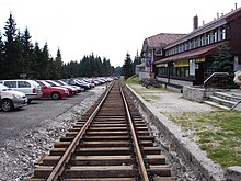
The Jelenia Góra – Kořenov railway from Lower Silesia to Bohemia runs over the pass . Jakuszyce station at an altitude of 886 m is Poland's highest station on a standard-gauge line . Up until 1997, freight trains from the direction of Jelenia Góra ran on the route to Jakuszyce. On August 28, 2010, cross-border travel that had been abandoned as a result of the Second World War was resumed.
Exchange of territory between Czechoslovakia and Poland in 1958
To the south of the pass, on the slopes of the Jizera Mountains, lies a jungle-like wasteland. The abandoned station Nowy Świat ( New World ) following Jakuszyce is located about five kilometers south of the pass in the middle of the forest, still on Polish territory, and was the stop for the Bohemian town of New World ( Nový Svět ) before the Second World War . Only after another kilometer did the route cross the state border with Czechoslovakia . The (now) first station on Czech territory, Harrachov , one kilometer below the limit used to be called Tkacze and was as well as the subsequent three kilometers of railway to the river Jizera ( Iser ) 1958 also in Poland.
In 1958 the border was cleared through an exchange of territory between Czechoslovakia and Poland. In the process, Czechoslovakia acquired the two Polish hamlets Zieliec ( Hope Valley ) (today: Údolí Naděje ) and Tkacze ( Strickerhäuser ) (today: Mýtiny ), which were located on the southern tip of the Polish territory that spanned the southern Bohemian side of the Jizera Mountains. In return, Poland was given an area of the same size on the former Czech northern flank of the Mrtvý vrch ( Todtenberg , 1060 m), east of the Neuweltpass in the Giant Mountains, which is also still south of the pass.
The State Treaty on Territorial Exchange was signed on October 10, 1958.
literature
- Ivo Łaborewicz: Tkacze - trzynaście lat w Polsce . SUDETY, No. 7/8, Wrocław 2002.


