Jump Off Joe
| Jump Off Joe | ||
|---|---|---|
|
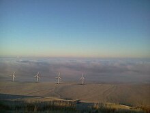
The Jump off Joe from Thompson Hill in Kennewick of view |
||
| height | 671 m (North American Vertical Date of 1988 according to Peakbagger.com) | |
| location | Benton County , Washington , USA | |
| Mountains | Horse Heaven Hills | |
| Dominance | 44.43 km | |
| Notch height | 219 m | |
| Coordinates | 46 ° 6 '14 " N , 119 ° 7' 48" W | |
| Topo map | USGS Johnson Butte | |
|
|
||
| Development | Street | |
The Jump Off Joe is a Härtling in the Horse Heaven Hills south of Kennewick in the State of Washington . It towers over the Tri-Cities and is widely visible in most of the region, even from Counties Umatilla and Morrow in Oregon . A gravel road reaches the summit from the south over a steep climb. On a clear day, visitors can see Mount Hood , Mount Adams, and Mount Rainier in the distance.
The great prominence of Jump off Joe makes it the ideal place for setting up radio, television and telecommunications masts; One of the masts erected is one for amateur radio , which covers most of the Columbia Basin. Two main television stations, the NBC spin-off KNDU-TV and the ABC spin-off KVEW have set up their transmitter masts on the mountain. VHF stations with transmitters on the summit may be available. a. KUJ-FM and KORD-FM.
geology
The Jump off Joe and the higher Horse Heaven Hills are geologically anticlines within the Yakima Fold Belt . The Belt ( German belt ) is a series of faults that extends over south-central Washington and are part of the larger Olympic-Wallowa lineament . The lineament runs from Port Angeles to the Wallowa Mountains in northeast Oregon.
The rocks in the region are predominantly basalts and as such are part of the Columbia River Basalt Group . It is believed that the origin of the lava flows is to be found at the Yellowstone hotspot , which was about 10 ... 15 million years ago in what is now West Idaho. These lava flows covered large parts of what is now Washington and Oregon as far as the Pacific Ocean with basalts up to 5,900 ft (1,800 m) thick.
During the last Ice Age , the ice sheets stretched into what is now the Idaho Panhandle , blocking the outflow of the Clark Fork River and creating Lake Missoula . Over a period of 2,000 years, the pressure of the dammed-up water led to dam bursts, which caused huge floods to flow into the Pacific. These floods built up again at the Horse Heaven Hills and flowed over the Wallula Gap , a few miles to the southeast, widening the breakthrough valley.
Climate and nature
Jump off Joe is located in an area with a semi-arid climate in the rain shadow of the Cascade Range . At about 2,000 ft (610 m) above the level of the Columbia River, there is more snow on Jump off Joe than in the Tri-Cities, and it doesn't melt for most of the winter. Strong winds in the area offer excellent opportunities for installing wind turbines for power generation. Like most of the central Columbia Basin, Jump off Joe is tree-free. The vegetation consists mainly of grasses and sagebrush .
Annual rainfall, measured at the nearest airport, Tri-Cities Airport in Pasco , is 7.94 in (201.7 mm). Daytime temperatures in summer can exceed 100 ° F (37.8 ° C). The Jump off Joe is sometimes above the clouds in inversion weather conditions that occur in the Columbia Basin under the influence of high pressure in winter.
See also
Individual evidence
- ^ Jump Off Joe, Washington . PeakBagger.com. Retrieved March 2, 2018.
- ↑ Kennewick's Mountain . Retrieved March 2, 2018.
- ^ Kennewick, Jump Off Joe, Washington, 145.41, N7LZM Repeater . RepeaterBook. Retrieved March 2, 2018.
- ↑ KNDU-TV TV Query Results . Federal Communications Commission . Retrieved March 2, 2018.
- ↑ KVEW-TV TV Query Results . Federal Communications Commission. Retrieved March 2, 2018.
- ↑ KUJ-FM Radio Coverage Map . Radio locator. Retrieved March 2, 2018.
- ↑ KORD-FM Radio Coverage Map . Radio locator. Retrieved March 2, 2018.
- ^ Field Trip Guide to the Columbia River Basalt Group . Pacific Northwest National Laboratory. May 2005. Retrieved February 4, 2019.
- ^ Ellen Morris Bishop: In Search of Ancient Oregon: A Geological and Natural History . Timber Press, Portland, Oregon 2003, ISBN 978-0-88192-789-4 .
- ^ John Eliot Allen, Marjorie Burns, Sam C. Sargent: Cataclysms on the Columbia: a layman's guide to the features produced by the catastrophic Bretz floods in the Pacific Northwest . Timber Press, Portland, OR 1986, ISBN 0-88192-067-3 , p 104 .
- ↑ Jump off Joe trail hike to the communications towers . Hike Tri-Cities. Retrieved March 2, 2018.
- ^ Monthly Temperature Charts, Pasco, WA . Retrieved May 31, 2015.
- ^ Above the Inversion of the Columbia Basin . Retrieved March 2, 2018.


