Köckte (Tangermünde)
|
Cooked
City of Tangermünde
Coordinates: 52 ° 29 ′ 50 ″ N , 11 ° 53 ′ 58 ″ E
|
||
|---|---|---|
| Height : | 35 m above sea level NHN | |
| Residents : | 69 (December 31, 2015) | |
| Incorporation : | September 30, 1928 | |
| Postal code : | 39590 | |
| Area code : | 039322 | |
|
Location of Köckte in Saxony-Anhalt |
||
|
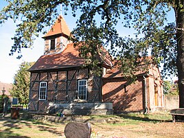
Gutskapelle zu Köckte (October 2018)
|
||
Köckte is a district of the city of Tangermünde in the Stendal district in Saxony-Anhalt (Germany).
geography
The area of the district lies between the Elbe and the Tangier , which flows into the Elbe a few kilometers northeast. Köckte lies in the floodplain of these two rivers, the Elbe meadows, and is therefore surrounded by a dike in the northwest. The city of Stendal is around 15 kilometers from Bölsdorf.
history
In 1345 a village is called Kokede , with the Margrave Ludwig von Bayern the v. Köckte enfeoffed. The horseshoe-shaped village, which existed as Kockde in 1441 , then died.
Köckte was later a manor .
On September 30, 1928, the Köckte manor district was united with the rural community of Bölsdorf . With the incorporation of the municipality of Bölsdorf into the city of Tangermünde on January 1, 2010, Köckte became a district of Tangermünde. Bölsdorf and Köckte together form the village of Bölsdorf in Tangermünde.
Attractions
The Gutskapelle Köckte is a half-timbered building from around 1730.
literature
Wilhelm Zahn : Local history of the Altmark . Edited by Martin Ehlies based on the bequests of the author. 2nd Edition. Verlag Salzwedeler Wochenblatt, Graphische Anstalt, GmbH, Salzwedel 1928, p. 91 .
Individual evidence
- ↑ District of Stendal, local transport plan 2017 (PDF)
- ^ Adolph Friedrich Riedel : Codex diplomaticus Brandenburgensis : Collection of documents, chronicles and other source documents . Main part 1st volume 6 . Berlin 1846, p. 462 ( digitized version ).
- ^ JAF Hermes, MJ Weigelt: Historical-geographical-statistical-topographical manual from the administrative districts of Magdeburg . Topographical part. Verlag Heinrichshofen, 1842, Volume 2, p. 297
- ↑ Administrative region of Magdeburg (Ed.): Official Gazette of the Government of Magdeburg . 1928, ZDB -ID 3766-7 , p. 209 .
- ↑ Thomas Hartwig: All Altmark churches from A to Z . Elbe-Havel-Verlag, Havelberg 2012, ISBN 978-3-9814039-5-4 , p. 272 .

