Köllerbach (Saar)
| Köllerbach | ||
|
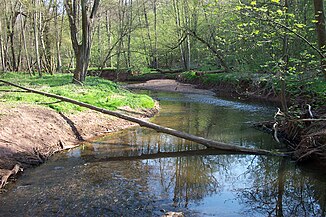
Köllerbach near Völklingen |
||
| Data | ||
| Water code | DE : 26438 | |
| location | Germany | |
| River system | Rhine | |
| Drain over | Saar → Moselle → Rhine → North Sea | |
| source | east of Eiweiler 49 ° 22 ′ 15 ″ N , 6 ° 57 ′ 31 ″ E |
|
| Source height | approx. 300 m above sea level NN | |
| muzzle | near Völklingen in the Saar coordinates: 49 ° 14 ′ 49 ″ N , 6 ° 51 ′ 40 ″ E 49 ° 14 ′ 49 ″ N , 6 ° 51 ′ 40 ″ E |
|
| Mouth height | approx. 195 m above sea level NN | |
| Height difference | approx. 105 m | |
| Bottom slope | approx. 5.4 ‰ | |
| length | 19.3 km | |
| Discharge at the Völklingen A Eo gauge : 77.6 km² Location: 1.6 km above the mouth |
MNQ MQ Mq MHQ |
197 l / s 1.07 m³ / s 13.8 l / (s km²) 22.5 m³ / s |
| Left tributaries | Köllerwieser Bach, Kirschhoferbach, Wahlbach, Dörschbach, Hermesbach | |
| Right tributaries | Schäferbach, Salbach, Sellerbach, Wimbach | |
| Medium-sized cities | Püttlingen , Völklingen | |
| Communities | Heusweiler | |
The Köllerbach is an approximately 19 km long orographically right tributary of the Saar in Saarland , Germany. It is the main body of water in the Köllertal .
Surname
Legend has it that the name comes from the charcoal burners who lived and worked in the forests of the Köllertal. The Köhler -Bach is said to have become the Köllerbach .
In fact, the brook is named after the oldest place Kölln in the Köllertal. As with the city of Cologne (lat. "Colonia Claudia Ara Agrippinensium"), its name goes back to a Roman name with part of Colonia . A Roman settlement was on the edge of the Köllertal, in the Püttling district of Ritterstraße. The Köllner Bach in the Köllner Tal then became colloquially the Köllerbach in the Köllertal .
geography
course
The Köllerbach rises at an altitude of approx. 300 m above sea level. NN about 1.7 km northeast of Eiweiler , a district of Heusweiler , on the southwest flank of the 338 m high Schwanenberg . From here the stream flows primarily to the south, after a short run it reaches the already mentioned Eiweiler, where the Köllerwieser stream joins from the left and the Schäferbach a little later from the right .
About 1 km further downstream, between Hirtel and Kirschhof , the Köllerbach crosses under the Autobahn 8 at the Heusweiler junction and reaches Heusweiler a little later. At the southern outskirts of the village, the Salbach flowing in from the west flows on the right . About 600 m further south the brook reaches the local border of Walpershofen , where the Wahlbach flows from the left , south of Walpershofen then again from the left the Dörschbach .
The Köllerbach then flows through Köllerbach , where Hermesbach, Sellerbach and Schäferbach flow in, as well as Püttlingen , where the Wimbach and Hermesborn reach it from the right and, after a few hundred meters, the Schlehbach from the left. After crossing Völklingen , the Köllerbach flows at 195 m above sea level. NN from the right next to the Karolinger Bridge into the Saar.
On its 19 km long path, the brook overcomes a height difference of 105 m, with an average bed gradient of 5.5 ‰. It has a catchment area of about 79 km².
Localities
- Eiweiler (district of Heusweiler)
- Heusweiler
- Walpershofen (district of Riegelsberg )
- Köllerbach (district of Püttlingen)
- Püttlingen
- Völklingen
Individual evidence
- ↑ a b Topographic map 1: 25,000
- ↑ Saarland surface water body lengths (PDF; 72 kB)
Web links
- Völklingen gauge (PDF file; 23 kB)
- Literature about the Köllerbach in the Saarland Bibliography
