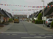
Kölner Landstrasse (Düren)
The Kölner Landstrasse is a historic main thoroughfare in the city of Düren , North Rhine-Westphalia . The road is classified as Bundesstraße 264 .
The Kölner Landstrasse begins today at Friedrich-Ebert-Platz and leads straight in an easterly direction past Distelrath via Golzheim , through the cities of Kerpen and Frechen to Cologne. Outside the city, the street has a different name.
The Collner suburb with the Collner Steinweg is already mentioned in the city map of Wenzel Hollar from 1634 . This began at the Kölntor , one of the city gates of Düren . The street was later called Kölner Chaussee . The name stayed until the end of the 19th century. The Catholic cemetery was laid out on the southern side of the then Kölner Landstrasse in 1786 and the Protestant cemetery on the northern side in 1825 . Later, in 1909, a water tower with a light fountain and a comprehensive system was built in today's roundabout (Friedrich-Ebert-Platz) , which was destroyed in 1944. The street from the city center to Friedrich-Ebert-Platz in Kölnstraße was later named.
Many shops and supermarkets as well as the Carmelite Convent , the Road Traffic Office, the Distelrath train station , the buildings of the Dürener Kreisbahn , the Rurtalbahn GmbH and the Rurtalbus GmbH are located on the Kölner Landstrasse . The oldest church in Düren, the Distelrath Chapel (Ühledömche) , is located in the Distelrath district, which is cut through by the street . On the outskirts is the settlement, popularly known as Tonnedbody . After crossing the Ellebach , the road climbs up the ice-age bank of the Rur on the edge of Merzenich and continues over the Schöne Aussicht to Golzheim.
The daily express carriage mail, which previously led via Jülich and Bergheim to Cologne, was relocated to the Kölner Landstraße in 1836 after the road was expanded in 1832. On July 15, 1855, regular passenger traffic to Cologne began in a three-horse, twelve-seater carriage.
In World War I , with the Council Decision of 9 September 1914 was the road for a short time after the conqueror of Liege, General Otto von Emmich in Emmichstraße renamed. The name was quickly lost after the war.
See also
swell
- List of streets on the website of the city of Düren (PDF; 58 kB)
- Josef Geuenich: The Düren street names , Düren 1965, published by the city of Düren and the Düren history association
Coordinates: 50 ° 48 ′ 20.1 ″ N , 6 ° 29 ′ 43.3 ″ E


