Küchlspitze
| Küchlspitze | ||
|---|---|---|
|
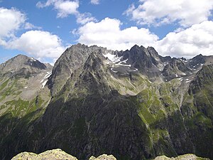
Küchlspitze (to the right of the glacier) from the west |
||
| height | 3147 m above sea level A. | |
| location | Tyrol , Austria | |
| Mountains | Kuchenspitzgruppe of the Verwallgruppe , Central Eastern Alps | |
| Dominance | 0.8 km → Kuchenspitze | |
| Notch height | 132 m ↓ notch to the top of the cake | |
| Coordinates | 47 ° 2 '29 " N , 10 ° 13' 57" E | |
|
|
||
| First ascent | Surveyors, around 1860 | |
The Küchlspitze (also: Küchlspitze ) is a three thousand ( 3147 m above sea A.. ) In Verwall between punch Valley and Paznaun in the west of North Tyrol .
Location and landscape
The mountain rises southeast between St. Anton am Arlberg in Stanzertal and Ischgl in Paznaun. To the northeast of the summit is the Darmstädter Hut .
The Küchlspitze ("small cake peak") is the third highest peak in the group after the Hohen Riffler and the one meter higher Kuchenspitze, which is located directly to the north . It is a concise triangular pyramid. In the main ridge, the east ridge runs to the Rautejöchli ( 2757 m above sea level ) and Rautekopf ( 2849 m above sea level ), the south-west ridge to the Schönpleisjöchli ( 2757 m above sea level ) and the Schönpleisköpf (northward 2243 m above sea level ) on both sides . , South 2920 m above sea level ), and the north ridge pulls in an S-shape to the Kuchenspitze. The mountain is glaciated, in the Nordkar to the Kuchenspitze lies the Große Küchlferner . The Kleine Küchlferner on the western flank is now just a remains of a glacier .
The Große Küchlferner drains to the Kartellspeicher and the Moosbach to the Rosanna , the western flank, with a cirque lake at 2530 m above sea level. A. to the Fasulbach , which approaches the upper Rosanna. The Madleinalpe southeast, also with some cirque lakes , goes over the Madleinbach to Trisanna .
Development and ascent
The summit was first climbed by surveyors accompanied by a local chamois hunter in the course of the Third Austro-Hungarian Land survey around 1860, during which the main ridge of the Verwall was climbed.
The mountain is rarely climbed today. The approach is for example from St. Anton from Schönverwall at the Konstanzer Hütte directly or via the Kuchenjöchl , or via the Moosbachtal (Kartellspeicher), and from the south of Ischgl via the Madleinalpe , or from Mathon via the Friedrichshafner Hütte . The Darmstädter Hütte is usually the base hut. The climbs to the summit are then at least difficult (east ridge UIAA grade II / SACSAC ZS-), sometimes demanding climbing (for example over the Küchlspitze of south ridge IV +).
Individual evidence
- ↑ a b c d Peter Pindur, Roland Luzian, Andreas Weiskopf: 1790 Küchlspitze 3147 m in Alpine Club Guide Verwallgruppe 1988, p. 216 ff.
- ↑ Küchlspitze 3147m , entry in hikr.org.
-
↑ Tour reports (chronological):
Route no .: 730 Küchlspitze -Ostgrat- , ADI on stein-und-schnee.de, September 9, 2006;
Küchlspitze (3147m) - mountaineering like in 1880 , ADI on hikr.org, July 13, 2010.

