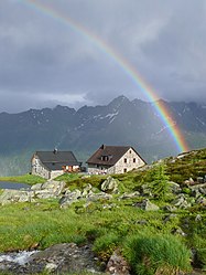
Friedrichshafener Hut
| Friedrichshafener Hütte DAV category I |
||
|---|---|---|
| location | on the Muttenalpe; Tyrol , Austria ; Valley location: Mathon | |
| Mountain range | Verwall | |
| Geographical location: | 46 ° 59 ′ 41 ″ N , 10 ° 12 ′ 56 ″ E | |
| Altitude | 2138 m above sea level A. | |
|
|
||
| owner | DAV - Friedrichshafen section | |
| Usual opening times | Early July to late September | |
| accommodation | 20 beds, 46 camps | |
| Winter room | 10 bearings | |
| Hut directory | ÖAV DAV | |
The Friedrichshafener Hütte is an Alpine Club hut of the Friedrichshafen section of the German Alpine Club on the Tyrolean side of the Verwall in Austria .
location
The Friedrichshafener Hütte, which was privately owned by the Alpine Club in 1924, is 2138 m above sea level. A. high on the Muttenalpe above the Paznaun Valley . The view to the south of the Silvretta is excellent. There is a small lake at the hut.
Accesses
- from Mathon , 2 hours
- from Galtür to the hamlet of Piel and then soon further on the path coming from Mathon, 3 hours
- from Galtür via the eastern ridge of the Adamsberg called Sonnenkogel , 3 hours
All three climbs run on the southern slope and are hot in the sun in the upper part.
Neighboring huts and crossings
- to Heilbronner Hütte via Muttenjoch, "Friedrichshafener Weg", 3 hours
- to the Konstanzer Hütte
- over the Schafbicheljoch (Schafbüheljoch) and through the Fasultal, 3 hours
- over the Muttenjoch, "Friedrichshafener Weg", through the Ochsen- and Schönverwalltal, 4.5 hours, not as rewarding as the way over the Schafbicheljoch
- to the Darmstädter Hütte over the Rautejöchli, "Ludwig-Dürr-Weg", approx. 6 hours, the path leads at the end over the Großer Küchlferner or its remains, the path requires alpine experience.
summit
In the vicinity of the huts there are some less prominent peaks that hikers can take along from the connecting paths between the huts. The paths to the peaks are marked.
- Vertinespleiskopf , 2706 m , and on to the Vertineskopf , 2685 m , from the Friedrichshafener Hütte over the Schafbicheljoch to the peaks, 2 hours, the path can be continued south to the Friedrichshafener Weg and Muttejoch.
- Gaisspitze , 2779 m , from the Friedrichshafener Hütte over the Muttejoch to the summit, just under 2 hours.
Sources and literature
- Peter Pindur, Roland Luzian, Andreas Weiskopf: Alpine Club Leader Verwall Group . Bergverlag Rother, 10th edition, 2005, ISBN 3-7633-1251-X
- Alpine Club Card AV 28/2, 1: 25,000, Verwall Group - center
- Alpine Club Card AV 28, 1: 50,000, Verwall Group
Web links
Commons : Friedrichshafener Hütte - Collection of images, videos and audio files
Individual evidence
- ^ Austrian Board of Trustees for Alpine Safety (ed.): Austria's Wanderdörfer . S. 28 ( austria.info [PDF; accessed on July 25, 2010]).


