
Kalvarienberg (Bad Ischl)
| Calvary | ||
|---|---|---|
| height | 606 m above sea level A. | |
| location | Bad Ischl | |
| Mountains | Kater Mountains , Osterhorn Group , Salzkammergut Mountains | |
| Coordinates | 47 ° 42 '52 " N , 13 ° 36' 23" E | |
|
||
| Type | Spornberg ( Traun - Ischl ) | |
| rock | Marl ( Flachwassergosau ) and limestone (Bunter Kalk) | |
| particularities | City mountain of Ischl, Ahorner Calvary Church with Stations of the Cross | |

The Kalvarienberg is a 606 m above sea level. A. high city mountain of Bad Ischl in the Salzkammergut in Upper Austria .
Location and landscape
The Kalvarienberg is located west of the Ischl city center , which is built at the confluence of the Ischl (Ischler Ache) , the outflow from the Wolfgangsee into the Traun . The Ischl breaks through a lateral threshold of the Trauntal, which is formed in the north of Bad Ischl by the Jainzenberg ( 834 m above sea level ) on the Zimnitz and in the west towards the Wolfgangtal by the Kalvarienberg on the Katergebirge . As a result, the Kalvarienberg, which rises about 100 meters above the valley floor, forms a foothill of the Katrin ( 1542 m above sea level ) and ends in the headland of the city center (Ischl estuary 463 m above sea level ).
Towards the Katrin, on the Katereck hill ( 594 m above sea level ), there is the saddle of the Ahorn , and then the furrowing of the Kaltenbach , which flows into the Traun in the Kaltenbach district . There, in the Ischl basin, the third town mountain of Ischl, the Siriuskogel ( 599 m above sea level ) south of the center, forms the narrow point of the Traun. To the west, the Kalvarienberg stretches out in a valley shoulder that drops via Lindau (whose Klapf 566 m above sea level ) to Ramsau ( 507 m above sea level on the Ischl). In the north, the lower Ischl accompanies the Kalvarienberg, here is the quarry district . In the south, behind Lindau, is the basin of the Nussensee , isolated by a 680 m high bar.

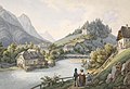
Stitch, c. 1855, from Picturesque Old Europe (with the Traun Bridge)
Motif from Bad Ischl 1857, Ernst Welker (with the Ischl bridge)
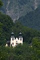
The Kalvarienbergkirche, today in the forest (2013)


geology

The Kalvarienberg is a piece of Flachwassergosau , which is a marl that represents old lake basins during the formation of the Limestone Alps. This old valley level now forms the shoulders on both sides of the Wolfgang Valley. The north flank, on the other hand, is a limestone known as Bunter Kalk, from the Jura ( Kimmeridge - Tithon , around 150 million years old). Opposite the Oberalm formation continues on the terrace of the Kaiservilla and then the Plassenkalk of the Jainzenberg continues, so that the Kalvarienberg – Jainzen-Zug can be seen as the Riegelberg of the Wolfgang valley . To the north in front of the Bunter Kalk as well as in the city's basin lie young gravel sands , which represent marginal moraine and old valley races .
The Maria-Louisen-Quelle , a brine spring , rises at the north foot . It is deep, old groundwater (approx. 10,000 years old) with 24% salinity. The source was recently revised.
History and Development
On the Kalvarienberg on the town side is the Kalvarienbergkirche from the Baroque period, to which the Ischler Kreuzweg leads up.
At the northern foot of the Kalvarienberg there is a quarry, the Falkensteiner sand, gravel and gravel works . This dismantling gave the whole district its name.
The Kalvarienberg summit itself is wooded and is a popular walking area as the town's recreational area. As early as the beginning of the summer freshness of the 1820s, some smaller pleasure facilities were built here, for example the Belvedere by a Dr. Brandt (1828), and Eleonorens Solitude , a favorite place of Countess Eleonore von Fuchs. The Elisabeth Forest Trail still runs on the northern slope today . This was laid out in 1899 in memory of the deceased Empress .
Web links
Individual evidence
- ↑ a b Emil ∗∗ (anonymous.): Visits to the lake and the Alps in the vicinity of Ischlel's. With geographical vignettes and an overview map of the country above the Enns by F. Raffelsberger. Verlag kkap first typographic art print (in commission by J. Hermann and Son am Graben), Vienna 1842, appendix to the lake and alpine images, 2nd entertainment tariff , p. 142 ff ( digitized version, Google, complete view ).
- ^ Theodor Hartwig: Pocket book (handbook) for travelers through southern Bavaria, Tyrol, Vorarlberg, Salzburg and the Salzkammergut. 3rd edition, Verlag Joseph Lindauer'sche Buchhandlung, Munich 1842, p. 345 (1st edition paperback for travelers through Bavaria's and Tyrol's highlands ; digitized, Google, complete view ).
- ↑ Around the Kalvarienberg (Elisabeth Waldweg-Leschetitzkyhöhe-Kalvarienbergkirche). Gerhard König on alpenvereinaktiv.com: Hike • Bad Ischl (as of November 2, 2015, accessed March 15, 2017).