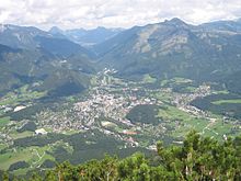
Ahorn (Bad Ischl municipality)
|
Ahorn ( district ) locality cadastral municipality Ahorn |
||
|---|---|---|
|
|
||
| Basic data | ||
| Pole. District , state | Gmunden (GM), Upper Austria | |
| Judicial district | Bad Ischl | |
| Pole. local community | Bad Ischl | |
| Coordinates | 47 ° 42 '44 " N , 13 ° 36' 0" E | |
| height | 540 m above sea level A. | |
| Residents of the village | 608 (January 1, 2020) | |
| Building status | 169 (2001 ) | |
| Area d. KG | 2.09 km² | |
| Post Code | 4820 Bad Ischl | |
| Statistical identification | ||
| Locality code | 08633 | |
| Cadastral parish number | 42001 | |
| Counting district / district | Bad Ischl-Outskirts-West (40703 012) | |
| Source: STAT : index of places ; BEV : GEONAM ; DORIS ; | ||
Ahorn is a location in the Salzkammergut in Upper Austria as well as a district , locality and cadastral municipality of the municipality of Bad Ischl in the Gmunden district .
geography

The place is located directly west of Ischl city center , between the Kalvarienberg ( 606 m above sea level ) and the foot of the Katrin , the hill Katereck ( 594 m above sea level ).
The local situation extends over 2½ kilometers. It begins at Eglmoosgasse , and then extends on both sides of the Ahornstraße , which runs over the saddle between Kalvarienberg and Katereck (approx. 560 m above sea level ), and then leads back down into the Wolfgang valley not far from the Ischl bridge of the B158 near Haiden . The Lindaustraße , which comes up from the Kaltenbach riding facility south of it, continues as a high road to Lindau .
The village of Ahorn comprises a little under 200 buildings with around 550 inhabitants.
The cadastral municipality of Ahorn with 208.60 hectares also includes the town of Steinbruch north below the Kalvarienberg on the B158 and the Ischl . This forms the northern border of the cadastral area.

( motif from Bad Ischl , Ernst Welker , 1857)
|
Haiden (KG)
|
Quarry (Stt., O) |
Jainzen (Stt., O and KG)
|
| Lindau (O and KG) | Bad Ischl (Stt., O and KG) | |
|
Kaltenbach (Stt., O and KG)
|
History, infrastructure, culture and sights

Until the middle of the 19th century, the Ahorn corridor , on the market side under the Kalvarienberg, which is documented for the first time in 1551, was completely uninhabited. The only homestead here was the Haißperger . Only after the saddle were there several farmsteads and some Sacherl, such as Kral- und Reitergut , Wehrmeister , Justl- and Zopfengütl, and a few houses facing the Ischl, a total of around 25 buildings. Only with the onset of the summer freshness boom of the Wilhelminian era were mainly more or less magnificent villas in prime locations; around 1900 there were already 50 houses. Since then, the village has largely grown together with the city center, with the exception of the more remote locations towards Lindau. The original field maple below the Kalvarienbergkirche, formerly Wiese, is now wooded.
The Kalvarienbergkirche is a baroque church that stands prominently above Ischl. There are other small buildings on the Way of the Cross in the area.
A little above the pass (junction Rudolf-von-Alt-Weg / Thomas-Ender-Weg) is the Leschetizkyhöhe , a beautiful vantage point. It is named after the musician Theodor Leschetizky , who was often a summer guest in Ischl. Also Johannes Brahms appreciated the place (that it here around 1880 the lullaby " Brahms' Lullaby / Lullaby" wrote, should, however, be just a local story, it emerged in 1868 in Bonn). Today the height is equipped with benches under an old sycamore tree and a monument to the namesake.
proof
- 40703 - Bad Ischl. Community data, Statistics Austria .
- ↑ Population on January 1, 2015 by location . Statistics Austria (pdf).
- ↑ a b c d Ibid. At the Kalvarienbergkirche, the Franziszäischer Cadastre 1817–1861 also located the name ( original map , as a layer online at DORIS , various map topics , such as first country recordings , original map quality, in particular the original map or cultural atlas ).
-
↑ a b c Kurt Klein (edit.): Historical local dictionary . Statistical documentation on population and settlement history. Ed .: Vienna Institute of Demography [VID] d. Austrian Academy of Sciences . Salzburg part 1, Bad Ischl: Ahorn , p. 84 ( online document , explanations . Suppl . ; both PDF - oD [updated]). Special references:
1551: After Christa Loidl: The names of the Ischlland farms. Diss., Univ. Vienna 1966.
-
↑ Teodor Leszetycki. Museum of the City of Bad Ischl (stadtmuseum.at, accessed March 15, 2017);
In the footsteps of Theodor Leschetizky in Bad Ischl. Eurothermen Bad Ischl> Excursions (accessed March 15, 2017). -
^ For example: Famous artists visit Ischl. City of Bad Ischl: Interesting facts about Bad Ischl (accessed March 15, 2017);
Johannes Brahms - Good evening, good night. Evangelical Museum Austria (accessed March 15, 2017).


