Jainzenberg
| Jainzenberg | ||
|---|---|---|
|
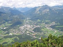
City of Ischl and Jainzenberg with Kaiserpark (left at the foot; from Siriuskogel ) |
||
| height | 834 m above sea level A. | |
| location | Bad Ischl | |
| Mountains | Zimnitz , Schafberg Group , Salzkammergut Mountains | |
| Coordinates | 47 ° 43 '15 " N , 13 ° 37' 28" E | |
|
|
||
| Type | Inselberg | |
| rock | Limestone ( Plassenkalk ) | |
| Age of the rock | ~ 150 million years ( Kimmeridge - Berrias ) | |
| particularities | Stadtberg von Ischl, imperial villa | |
The Jainzenberg , often just Jainzen for short , is 834 m above sea level. A. high city mountain of Bad Ischl in the Salzkammergut in Upper Austria .
Location and landscape

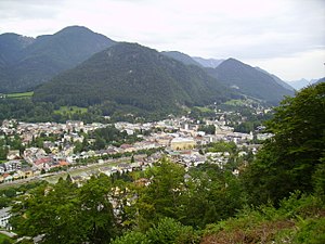
The Kalvarienberg is located north of the Ischl city center , which is built at the confluence of the Ischl (Ischler Ache , the outflow of the Wolfgangsee ) s into the Traun . The Ischl breaks through a lateral threshold of the Trauntal against the Wolfgangtal , which in the west of Bad Ischl through the valley terrace of Ahorn and the Kalvarienberg ( 834 m above sea level ) on the Katergebirge and in the north through the Jainzenberg on the Zimnitz (Leonsberg) ( 1745 m above sea level ). From the Zimnitz, the Jainzenberg, which rises about 250 meters above the valley floor, is exposed by the Jainzental (saddle height 549 m above sea level ) so that it forms an island mountain on the Ischler basin .
At the west foot, already in the valley of the Ischlerache, is the Ischler district Jainzen . The park area of the Kaiservilla (Kaiserpark) is located on a terrace at the southern foot , and the Schmalnau location at the mouth of the Ischl ( 463 m above sea level ), which is now largely from the Bad Ischl-Mitte / Ost junction of Wolfgangsee Strasse (B158) to the Salzkammergutstrasse (B145) is taken. The 680 m long Kaiserpark tunnel of the B145 runs between Ischler Ache at the Bad Ischl-West and Ischl-Mitte junction . Opposite the west ridge of the Hohen Schrott rises ( 1839 m above sea level ), here the Ischl basin begins to narrow towards the northeast. The village of Roith is located there at the eastern foot of the Jainzenberg .
geology

The Jainzenberg is a piece of Plassenkalk , a particularly light- colored reef or fine rubble limestone from the Jura / Cretaceous turn (Upper Kimmeridgium - Berriasium , around 150 million years old), which is particularly widespread in the direction of Ausseerland and on the Schafberg embedded in the Dachstein limestone. To the north, however, lies the much older main dolomite of the Upper Triassic (Upper Carnian – Norian, around 230 million years old).
The front terrace of the Kaiserpark is the Oberalm formation , in the Schmalnau at the southern foot there is the Schrambach formation , these are marl limestone or limestone from the same period as the Plassen limestone, which represent deeper debris sediments. Embedded is the Haselgebirge , a gypsum-clay breccia from the turn of the Permian / Triassic period (approx. 250 million years old), it forms the striking, dry, steep corridor at the federal highway junction. The west foot is Flachwassergosau , a marl from much younger lake basins during the formation of the Limestone Alps.
The Kalvarienberg – Jainzen-Zug can be seen as the Riegelberg of the Wolfgangtal to the Trauntal, this old valley level today forms the shoulders on both sides of the Wolfgangtal.
The Jainzental was probably formed in a retreat phase of the Traungletscher by the erupting original Wolfgangsee , later the Ischl broke through between the Jainzenberg and Kalvarienberg. The Kreuzstein (old coal stone ) in the middle of the Traun at the foot of the mountain between the Ischl and Rettenbach estuaries is not a landslide, but an erratic block of the ice ages.
History and Development
There is a complex of legends about Jainzen: The Pfennigbach , at the mouth of the Ischl near the Gaßnergütl (today's Gassnergasse near the Kaiservilla), rises from a cave, the gravel hole (near the old quarry near the red giant ). From this a corridor leads to a lake inside the mountain. There should have been gold there, and "Bergmandl", "Zwerge" or "Wälsche Mandl" ("Dalmatian") live in it, or came and hung "Sackcloths in this brook and caught gold sand in it". The Jainzenberg once "stood on three golden pillars", guarded by the dwarfs, one was "stolen during the migration of the peoples". The dwarfs are also said to have washed laundry in the Pfennigbach and dried it on Lidlkögl , a rock "with enormous stone steps" (behind today's imperial villa).
In the course of the beginning of the summer freshness in the Salzkammergut, a number of pleasure facilities were created that were open to the public, such as the Dänenweg , which was built by the King of Denmark, Christian VIII. , At his own expense, together with Christian's Greetings and The Two Brothers , or Comtessenplatz , by Filippine and Eleonore Batthyány donated in 1824.
In 1834 a villa was built at the foot of the building, which was given to Emperor Franz Joseph I and Empress Elisabeth (Sisi) as a wedding present in 1853 , and was converted into an imperial villa as a summer residence . The whole park - as such and as a building ensemble - is a listed building. The Jainzenberg belonged to the property from this time on. The couple regularly spent the summer here, later only the Kaiser alone. Elisabeth is said to have appreciated the Jainzenberg as a walk, Franz Joseph also hunted here.
Web links
Individual evidence
- ↑ Albert Depiny (ed.): Upper Austrian saga book. Linz 1932, chap. 1. Hidden Treasures / Bergmandl und Zwerge , No. 11, 13, 14, pp. 30–31, and chap. 7. Die wälschen Mandl , No. 121, pp. 79–81 (online: Chapter 1. , Chapter 7. , landessagen.at; Chapter 1. , Chapter 7. , haben.at).
- ↑ a b Emil ∗∗ (anonymous.): Visits to the lake and the Alps in the vicinity of Ischlel's. With geographical vignettes and an overview map of the country above the Enns by F. Raffelsberger. Verlag kkap first typographic art print (in commission by J. Hermann and Son am Graben), Vienna 1842, appendix to the lake and alpine images, 2nd entertainment tariff , p. 142 ff ( digitized version, Google, complete view ).
- ↑ a b Theodor Hartwig: Pocket book (manual) for travelers through southern Bavaria, Tyrol, Vorarlberg, Salzburg and the Salzkammergut. 3rd edition, Verlag Joseph Lindauer'sche Buchhandlung, Munich 1842, p. 345 (1st edition paperback for travelers through Bavaria's and Tyrol's highlands ; digitized, Google, complete view ).
- ^ A b Franz Anton Alexander von Braune: The little foreign guide to Ischl and its surroundings. Paperback for travelers and bathers, containing brief indications of the current state of Ischl, the bathing establishments, pleasure facilities, the land, sea, mountain and alpine parts, together with details of several travel tours. Verlag der Mayr'schen Buchhandlung, Salzburg 1843, chapter overview of the pleasure systems ... , p. 72 f ( digitized, Google, complete view ).
- ↑ Follow in Sisi's footsteps: The Kaiserpark in Bad Ischl. habsburger.net (accessed March 19, 2017).

