Kamenice (Elbe)
|
Kamenice Kamnitz |
||
|
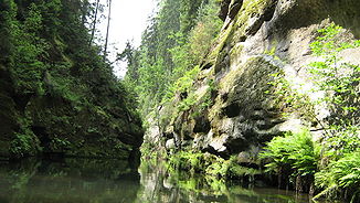
The Kamenice in the Edmundsklamm |
||
| Data | ||
| Water code | CZ : 1-14-05-001 | |
| location | Czech Republic | |
| River system | Elbe | |
| Drain over | Elbe → North Sea | |
| source | south of Jedlová train station in the Lusatian Mountains 50 ° 50 ′ 19 ″ N , 14 ° 34 ′ 14 ″ E |
|
| Source height | 595 m nm | |
| muzzle | At Hřensko in the Elbe coordinates: 50 ° 52 '28 " N , 14 ° 14' 10" E 50 ° 52 '28 " N , 14 ° 14' 10" E |
|
| Mouth height | 115 m | |
| Height difference | 480 m | |
| Bottom slope | 13 ‰ | |
| length | 37.5 km | |
| Catchment area | 217.2 km² | |
| Drain |
MQ |
2.65 m³ / s |
The Kamenice (German Kamnitz ) is a right tributary of the Elbe in northern Bohemia in the Czech Republic . It rises at 595 m in the Lusatian Mountains in Bohemia on the ridge of the Stožec ( Schöber , 665 m) south of the Jedlová train station . The largest tributary is the Chřibská Kamenice (Kreibitzbach) . It flows into the Elbe in Hřensko (Herrnskretschen) on the Czech-German border. The name is derived from the Slavic adjective kamenný (German: stony) and means something like river with stony bed. The Kamenice was already known for its abundance of fish, especially salmon . The water power was used to drive mills, paper mills and sawmills, bleaching yards were operated and wood was rafted .
course
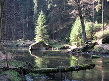
The Kamenice flows into the Hranični rybník (Waldstein pond ) , which it leaves again in the direction of Kytlice . Immediately after the village of Srbská Kamenice (Windisch-Kamnitz) it unites with the Chřibská Kamenice and enters the sandstone cliffs of Bohemian Switzerland . The narrow and deep canyons are known as the Kamnitzklammen . The Ferdinand gorge (Ferdinandová soutěska) is the first; boat trips were possible in it until 1945. At the end of this gorge, before the inflow of Jetřichovická Bělá , it is spanned by the oldest reinforced concrete bridge Bohemia and reaches the ruins of the Grundmühle (Dolský Mlyn) , a once popular Ausflugsgaststätte. This is followed by the Wild Gorge (Divoká soutěska) , which is followed by the Edmundsklamm (Edmundova soutěska , after 1945 also Tichá soutěska) at Mezná . The river is dammed in these two Kamnitz gorges and boat trips are possible. In the past, these reservoirs , like those on the Kirnitzsch , served as water reservoirs for logging .
The absolute gradient on the 37.5-kilometer route to the Elbe is 13.41 per thousand. The Kamnitz flows through the town of Česká Kamenice (Böhmisch Kamnitz) on its way to the west . Tributaries of the Kamnitz are the Lísecký potok , the Pryskský potok , the Chřibská Kamenice , the Jetřichovická Bělá and the Dlouhá Bělá .
literature
- Sophus Ruge: Dresden and Saxon Switzerland. 2nd Edition. From the series Land and People - Monographs on Geography. Publisher Velhagen & Klasing, Bielefeld / Leipzig 1913.
- Topographic maps (measuring table sheets) Saxony M 1: 25,000, department for land survey of the Königl. Saxon. General Staff, sheet 106: Section Waltersdorf, St. Georgenthal, sheet 105: Section Am Raumberg, Böhmisch-Kamnitz, sheet 104: Section Schöna. Various Editions, Leipzig 1905–1942.
- Topographic map scale 1: 50,000 Lužické hory-mapa KČT c.14 KČT, 2008, ISBN 978-80-7324-078-3 .
- Topographic map scale 1: 50,000 Národní park Ceské a Saské Švýcarsko. Mapa KCT c.12 from the zelené edice KČT, KČT 2007.


