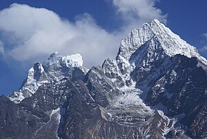
Kantega
| Kantega - Kangtega - Kantaiga | ||
|---|---|---|
|
Kantega (left), Thamserku (right) |
||
| height | 6783 m | |
| location | Solukhumbu District ( Nepal ) | |
| Mountains | Mahalangur Himal ( Himalaya ) | |
| Dominance | 8.77 km → Ama Dablam | |
| Notch height | 1143 m ↓ ( 5640 m ) | |
| Coordinates | 27 ° 47 '33 " N , 86 ° 49' 1" E | |
|
|
||
| First ascent | June 5th, 1963 by David Dornan , Tom Frost , Michael Gill , Jim Wilson | |
The Kantega (also Kangtega or Kantaiga ) is a six-thousander in the Khumbu region in Nepal , east of Namche Bazar and south of Pangboche in the so-called Hinku Himal .
South of the 6783 m high Kantega are the Kyashar ( 6770 m ) and Kusum Kanguru ( 6370 m ), west of the Thamserku ( 6623 m ), east of Malanphulan ( 6573 m ) and Peak 41 ( 6548 m ) and northeast of the Ama Dablam ( 6856 m) ).
The Kantega is connected to the Thamserku by a mountain ridge. Both mountains form a prominent southern panorama on the trekking routes starting from Namche Bazar. The Phungi Glacier flows from its intermediate ridge in a north-easterly direction , and at lower altitudes it merges into a glacier stream , the Phungi Khola . The mighty King Taiga Glacier flows from the south side of the Kantega , and from the southeast side the Hinku Nup Glacier , which is already part of the Makalu Barun National Park .
Ascent history
An expedition led by Edmund Hillary managed to climb the Kantega in June 1963. The ascent route led from the Hinku Glacier over the eastern flank of the mountain. The two Americans David Dornan and Tom Frost and the two New Zealanders Michael Gill and Jim Wilson reached the summit on June 5th.
Kantega seen from Pheriche .


