Canton of Mururata
| Canton of Mururata | ||
|---|---|---|
| Basic data
|
||
| Residents (state) | 2082 pop (2001) | |
| height | 1600 m | |
| Coordinates | 16 ° 4 ′ S , 67 ° 46 ′ W | |
|
|
||
| politics
|
||
| Department | La Paz | |
| province | Nor Yungas Province | |
| Municipio | Municipio Coroico | |
| Central place | Mururata | |
| climate | ||
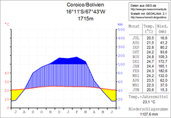
 Coroico climate diagram |
||
The canton of Mururata is an administrative district in the La Paz department in the South American Andean state of Bolivia .
Location in the vicinity
The canton of Mururata is one of three cantons of the district ( Bolivian : Municipio ) Coroico in the province of Nor Yungas and is located in the northwestern part of the district. It borders the province of Caranavi to the northeast , the province of Murillo to the north and west , the canton of Pacollo to the south , and the canton of Coroico to the east .
The canton extends between 15 ° 59 'and 16 ° 09' southern latitude and 67 ° 39 'and 67 ° 51' western latitude, it measures up to 20 kilometers from north to south and from west to east. The canton has 31 localities ( localidades ), the central place is Mururata with 236 inhabitants ( 2001 ) in the eastern part of the canton.
geography
The canton of Mururata is located in the Bolivian Yungas on the eastern slope of the Andes mountain range of the Cordillera Real . The region's climate is typical of the time of day , with mean temperatures fluctuating more during the day than during the year.
The annual precipitation here in the subtropical Yungas is 1100 mm (see Coroico climate diagram) and has a clear dry season from May to August and a rainy season from December to February. The monthly average temperatures fluctuate only slightly between 20 ° C and 25 ° C, during the day it is warm in summer and pleasantly cool at night.
population
The population of the canton is between the last two censuses has increased by about five percent. For the decade up to 2010, the official population estimate for the Municipio Coroico assumes a similar development as in the decade before 2001.
| year | Residents | source |
|---|---|---|
| 1992 | 1,979 | census |
| 2001 | 2,082 | census |
| 2010 | . | no data yet |
Due to the historical population development in the Municipio Coroico, the Aymara population is predominant, 62.1% of the population speak the Aymara language .
structure
The canton is divided into a total of 26 sub-cantons ( vicecantones ).
Individual evidence
- ^ Instituto Nacional de Estadística (INE) 2001
- ↑ Instituto Nacional de Estadística - Proyecciones (PDF; 2.3 MB)
- ^ INE - Instituto Nacional de Estadística Bolivia 1992
- ^ INE - Instituto Nacional de Estadística Bolivia 2001
- ↑ INE social data 2001 (PDF; 12.2 MB)
- ^ Instituto Nacional de Estadística
Web links
- Municipio Coroico - Politics, Population and Economy ( Spanish )
- Municipio Coroico - General Maps No. 21401
- Municipio Coroico - detailed map and population data (PDF; 571 kB) ( Spanish )
- Department of La Paz - social data of the municipalities (PDF 11.63 MB) ( Spanish )
