Canton Pacollo
| Canton Pacollo | ||
|---|---|---|
| Basic data
|
||
| Residents (state) | 1279 pop (2001) | |
| height | 2000 m | |
| Coordinates | 16 ° 12 ′ S , 67 ° 52 ′ W | |
|
|
||
| politics
|
||
| Department | La Paz | |
| province | Nor Yungas Province | |
| Municipio | Municipio Coroico | |
| Central place | Pacollo | |
| climate | ||
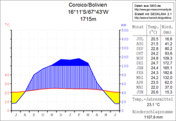
 Coroico climate diagram |
||
The canton Pacollo is an administrative district in the La Paz department in the South American Andean state of Bolivia .
Location in the vicinity
The canton of Pacollo is one of three cantons in the district ( Bolivian : Municipio ) Coroico in the province of Nor Yungas and is located in the southwestern part of the district. It borders the province of Murillo to the northwest and west , the province of Sud Yungas to the south, the canton of Coroico to the east, and the canton of Mururata to the northeast .
The canton extends between 16 ° 04 'and 16 ° 20' south latitude and 67 ° 44 'and 67 ° 58' west latitude, it measures up to 25 kilometers from north to south and west to east. The canton has 20 localities ( localidades ), the central place is Pacollo with 241 inhabitants ( 2012 census ) in the eastern part of the canton.
geography
The canton of Pacollo is located in the Bolivian Yungas on the eastern slope of the Andes mountain range of the Cordillera Real . The region's climate is typical of the time of day , with mean temperatures fluctuating more during the day than during the year.
The annual precipitation here in the subtropical Yungas is 1100 mm (see Coroico climate diagram) and has a clear dry season from May to August and a rainy season from December to February. The monthly average temperatures fluctuate only slightly between 20 ° C and 25 ° C, during the day it is warm in summer and pleasantly cool at night.
population
The population of the canton is between the last two censuses risen by about a third. For the decade up to 2010, the official population estimate for the Municipios Coroico assumes a similar development as in the decade before 2001.
| year | Residents | source |
|---|---|---|
| 1992 | 934 | census |
| 2001 | 1,279 | census |
| 2010 | . | no data yet |
Due to the historical population development in the Municipio Coroico, the Aymara population is predominant, 62.1% of the population speak the Aymara language .
structure
The canton is divided into a total of fifteen sub-cantons ( vicecantones ).
Individual evidence
- ^ Instituto Nacional de Estadística (INE) 2001
- ↑ Instituto Nacional de Estadística - Proyecciones (PDF; 2.3 MB)
- ^ INE - Instituto Nacional de Estadística Bolivia 1992
- ^ INE - Instituto Nacional de Estadística Bolivia 2001
- ↑ INE social data 2001 (PDF; 12.2 MB)
Web links
- Municipio Coroico - Politics, Population and Economy ( Spanish )
- Municipio Coroico - General Maps No. 21401
- Municipio Coroico - detailed map and population data (PDF; 571 kB) ( Spanish )
- Department of La Paz - social data of the municipalities (PDF 11.63 MB) ( Spanish )
