Canton of Valleraugue
| Former canton of Valleraugue |
|
|---|---|
| region | Languedoc-Roussillon |
| Department | Gard |
| Arrondissement | Le Vigan |
| main place | Valleraugue |
| Dissolution date | March 29, 2015 |
| Residents | 2,106 (Jan 1, 2012) |
| Population density | 18 inhabitants / km² |
| surface | 116.63 km² |
| Communities | 3 |
| INSEE code | 3036 |
The canton Valleraugue was 2015 a French canton in the Arrondissement Le Vigan , in the department of Gard and in the region of Languedoc-Roussillon . Its main town was Valleraugue and it was dissolved in 2015 as part of a nationwide reorganization of the cantons .
Communities
The canton consisted of three municipalities:
| local community | Population year | Area km² | Population density | Code INSEE | Post Code |
|---|---|---|---|---|---|
| Notre-Dame-de-la-Rouvière | 436 (2013) | 16.49 | 26 inhabitants / km² | 30190 | 30570 |
| Saint-André-de-Majencoules | 623 (2013) | 21.79 | 29 inhabitants / km² | 30229 | 30570 |
| Valleraugue | 1,039 (2013) | 78.35 | 13 inhabitants / km² | 30339 | 30570 |

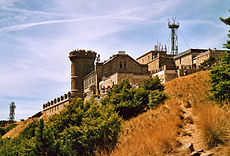
The Mont Aigoual is the highest mountain in the former canton
