Canton of Roquemaure
| Canton of Roquemaure | |
|---|---|
| region | Occitania |
| Department | Gard |
| Arrondissement | Nîmes |
| main place | Roquemaure |
| Residents | 26,989 (Jan. 1, 2017) |
| Population density | 159 inhabitants / km² |
| surface | 169.34 km² |
| Communities | 11 |
| INSEE code | 3017 |
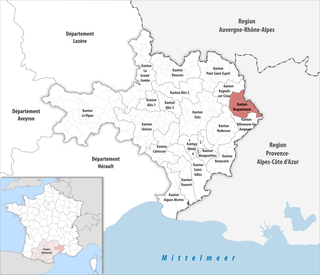
 Location of the canton of Roquemaure in the Gard department |
|
The canton of Roquemaure is a French constituency in the arrondissement of Nîmes , in the department of Gard and in the region of Occitania ; its main town is Roquemaure .
Communities
Since 2015 the canton has consisted of eleven municipalities:
| local community | Residents January 1, 2017 |
Area km² |
Density of population / km² |
Code INSEE |
Post Code |
|---|---|---|---|---|---|
| Codolet | 660 | 5.17 | 128 | 30084 | 30200 |
| Laudun-l'Ardoise | 6,292 | 34.19 | 184 | 30141 | 30290 |
| Lirac | 904 | 9.76 | 93 | 30149 | 30126 |
| Montfaucon | 1,492 | 4.24 | 352 | 30178 | 30150 |
| Roquemaure | 5,481 | 26.22 | 209 | 30221 | 30150 |
| Saint-Geniès-de-Comolas | 1,969 | 8.26 | 238 | 30254 | 30150 |
| Saint-Laurent-des-Arbres | 3,072 | 16.35 | 188 | 30278 | 30126 |
| Saint-Paul-les-Fonts | 1,031 | 5.46 | 189 | 30355 | 30330 |
| Saint-Victor-la-Coste | 2,073 | 26.64 | 78 | 30302 | 30290 |
| Sauveterre | 2,036 | 13.09 | 156 | 30312 | 30150 |
| Tavel | 1,979 | 19.96 | 99 | 30326 | 30126 |
| Canton of Roquemaure | 26,989 | 169.34 | 159 | 3017 | - |
Until the nationwide reorganization of the French cantons in March 2015, the canton of Roquemaure included the nine municipalities of Laudun-l'Ardoise , Lirac , Montfaucon , Roquemaure , Saint-Geniès-de-Comolas , Saint-Laurent-des-Arbres , and Saint-Victor-la -Coste , Sauveterre and Tavel . Its layout corresponded to an area of 158.71 km 2 . Before 2015 he had the INSEE code 3023.