Karlesgraben (Fußenau Canal)
|
Karlesgraben Karlsgraben |
||
|
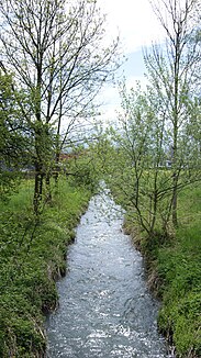
The Karlesgraben in Dornbirn, seen from the bridge at the ARA. |
||
| Data | ||
| Water code | AT : 81150602 | |
| location | Vorarlberg , Austria | |
| River system | Rhine | |
| Drain over | Fußenau Canal → Dornbirner Ach → Rhine → North Sea | |
| Source height | 430 m | |
| muzzle | in the Fußenau Canal Coordinates: 47 ° 26 '18 " N , 9 ° 43' 30" E 47 ° 26 '18 " N , 9 ° 43' 30" E |
|
| Mouth height | 405 m | |
| Height difference | 25 m | |
| Bottom slope | 8.5 ‰ | |
| length | 2.9 km | |

The Karlesgraben (also: Karlsgraben ) is a flowing body of water and the left upper reaches of the Fußenauer Canal (to the Dornbirner Ach ) in the city of Dornbirn , Dornbirn District , Vorarlberg , Austria .
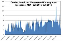
The Karlesgraben is canalized or piped for almost its entire length or denatured by artificial bank edging or an artificial stream bed. Its water flow varies greatly between very high after recent rainfall and poor after longer periods of drought.
Surname
The name Karlesgraben occurs exclusively for this body of water in Vorarlberg. The trench was created in 1831 by the manufacturer Karl Ulmer as the lowest part of the Müllerbach . The first name of Carl Ulmer was then eponymous for this stream. The Karlesgraben in Dornbirn gave its name to the arched residential streets Am Karlesgraben in the Forach district ( Rohrbach district ).
Previous history and source
Whether and to what extent the course of the Karlsgraben coincided with that of the Fischbach in earlier times is not known for certain. The Karlsgraben and Fischbach still flow largely parallel over a length of about 1.2 km on the upper reaches, with a distance of only 40 to 150 m from each other. The source of the Karlsgraben is likely to have come from the waters that seeped away from the Fallenberg , as well as the earlier Fischbach. For centuries, the water of the Karlsgraben was diverted and used for textile production.
Tributaries
Today's Karlesgraben rises below a factory hall of the FM Hämmerle company , former Fischbach factory (also: Rotfarb factory ) at kilometers of water (GeKm) 2.935 at about 430 m above sea level. A. and basically runs from southeast to northwest through the middle of the Dornbirn settlement area. It leads from the Fischbach plant piped under the Dr. Anton-Schneiderstraße (L3) through to the fire station and further under several commercial enterprises in the district of Schwefel. At around GwKm 2.13 a relief channel branches off to the north and flows back into the Karlesgraben at GwKm 1.825. Another branch leads from Karlesgraben into Müllerbach at GwKm 1.875. At GwKm 1.37 of the Karlesgraben, the Müllerbach flows into it as the most important feeder. The Karlesgraben takes up the Fliederweggraben at around GwKm 1,115. At GwKm 0.76, at the level of the Dornbirn-Schwarzach wastewater treatment plant, the rain overflow from the wastewater treatment plant leads into the Karlesgraben. At the lower end of the wastewater treatment plant, the Foracheckgraben feeds in (approximately at GwKm 0.625) and at GwKm 0.49 from the Forachgraben , each with a small inflow. The last inlet, for example at GwKm 0.249, is the feed of the Vorder Achgraben, just before the animal shelter.
The Karlesgraben joins the Fußenau plot with the Fischbach coming from the south at 405 m above sea level. A. to the Fußenauer Canal , which continues with the streamline of the Fischbach in the direction of the inflow of the Fischbach and then flows into the Dornbirner Ach .
Web links
Individual evidence
- ↑ Dornbirn Lexicon , keyword: Am Karlesgraben, V.
- ^ Albert Bohle in Dornbirn Lexikon , search term: Quellengasse, I.
- ↑ Franz Josef Huber , Harald Rhomberg: On the 200th birthday of the textile entrepreneur Franz Martin Hämmerle in Dornbirner Schriften No. 45, p. 51 ff.

