Katanga (Agadez)
| Quartier de Katanga District of Katanga |
|
|---|---|
| Coordinates | 16 ° 58 ′ N , 7 ° 59 ′ E |
| Basic data | |
| Country | Niger |
| Agadez | |
| department | Tchirozérine |
| ISO 3166-2 | NE-1 |
| Borough | Agadez |
| Residents | 4385 (2012) |
Katanga (also: Katanka ) is a district of Agadez in Niger .
Katanga is the largest area of the eleven historic area of the UNESCO World Heritage counting old town of Agadez , in the north-west it is. The neighboring districts are Amdit in the south and Amarewat , Founé Imé , Hougbéry and Angoual Bayi in the east - from north to south . Katanga includes the old districts of Hasna and Tafimata as well as the remains of the old district of Gao.
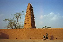
The place name Katanga comes from the Hausa language and means "(city) walls". This refers to the walled sultan's palace of Agadez . Other attractions in the district include the Great Mosque of Agadez , the Hassina Mosque, the residence of Sultan Almoumine, the House of Qādī , the Hôtel de l'Air and the restaurant Le Pilier, as well as the square of Kofar Sarki, the square the night market and the Sherif's Square .
The population is subordinate to the Gonto von Katanga, a traditional mayor who acts as a middleman between the Sultan of Agadez and the residents. Originally, Katanga did not have its own gonto , but the sultan ruled directly here. The special position of Katanga is still evident in the fact that the Gonto from Katanga is Dan Galadima , the personal representative of the Sultan.
At the 2012 census, Katanga had 4,385 inhabitants who lived in 754 households. At the 2001 census, the population was 3,403 in 543 households, and at the 1988 census, the population was 4,444 in 735 households.
Individual evidence
- ↑ a b Agadez. Plan de Gestion du center historique, 2012–2018. (PDF) Ministère de la Jeunesse, des Sports et de la Culture, January 2012, pp. 17–18 , accessed on January 30, 2018 (French).
- ↑ a b Aboubacar Adamou: Agadez et sa Région (= Études Nigériennes . No. 44 ). Pr. De Copédith, Paris 1979, p. 140 .
- ↑ Répertoire National des localites (ReNaLoc). (RAR) Institut National de la Statistique de la République du Niger, July 2014, p. 19 , accessed on 7 August 2015 (French).
- ^ Répertoire National des Communes (RENACOM). (RAR file) (No longer available online.) Institut National de la Statistique, archived from the original on January 9, 2017 ; Retrieved November 8, 2010 (French). Info: The archive link was inserted automatically and has not yet been checked. Please check the original and archive link according to the instructions and then remove this notice.
- ↑ Recensement Général de la Population 1988: Répertoire National des Villages du Niger . Bureau Central de Recensement, Ministère du Plan, République du Niger, Niamey March 1991, p. 25 ( ceped.org [PDF; accessed January 31, 2018]). www.ceped.org ( Memento of the original dated January 31, 2018 in the Internet Archive ) Info: The archive link was inserted automatically and has not yet been checked. Please check the original and archive link according to the instructions and then remove this notice.
