Khandesh (District)
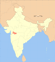
The district of Khandesh ( ख़ानदेश ) is an administrative division created during colonial times, which is today largely part of the Nashik Division of the Indian state of Maharashtra . The Dangs with Surgana , Mewas were also subordinate to the colonial District Commissioner (initially Collector ) . The district established after the British conquest of the region in the Third Mahratan War was divided several times in 1906 and after 1961.
Regional studies
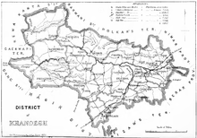
The undivided district of 25905 km² was on the northern Dekkan Plateau, between 20 ° 16 '- 22 ° 2' N and 73 ° 35 '- 76 ° 24' E. In the north it was bordered by the Satpura Mountains and the Narmada . In the east it was bordered by Berar and the Nemar district ( Central Provinces ). The southern border ran along the Chandor and Ajanta Hills. To the west lay the Nashik district , the Rewa Kantha Agency and the princely states of Baroda and Sambara . The region is traversed by the non-navigable Tapti from northeast to west. The southern areas are drained by Girna, Bori and Panjhra .
The mountains often go over 1000 m, whereby in the Satpuras the Toranmal 1155 mm, the Boksa Dongar 1208 m and the Ashtamba Dongar 1325 m. The region is one of the hottest in India; before the monsoon (June-October) in early summer (March to mid-June), daytime temperatures of over 40 ° C are regularly reached. The annual precipitation is 6–700 mm in good years at 900 m, of which over 85% falls during the monsoons .
The soils, mostly alluvial and then black soils, are very fertile between Tapti and the northern mountains. Lighter, loamy soils can be found around Dhule and Sakri. If the monsoon rains are sufficient, two harvests per year are possible, there was famine in the 19th century 1802–1804 (due to the war), 1823–1825, 1831–1836, 1838–1839, 1845, 1869 (locusts) and 1876–1877. The famines of 1896–1897 and 1900–1902 were devastating. The most important crops are wheat, jowar ( sorghum vulgare ), bajra (millet: Penicillaria spicata (L.) Willd.) And rice. Cotton cultivation, which began with seeds from Pernambuco in 1833/7 and was subsidized by the state for the next few decades, became the most important cash crop. During the Great Depression, peanuts were often substituted for cotton. Around Jalgaon, around 3% of the world banana harvest is achieved today.
The large number of large game according to early reports, also due to the deforestation of the last two centuries, was largely exterminated: elephants and lions in the 17th century, the Indian black bear ( Ursus labiatus ) around 1890, tigers up to the First World War , other big cats soon afterwards. The Thillari cattle, adapted to the hot local conditions, produce little milk, but were persistent draft animals.
population
The inaccurate population censuses officially gave for 1821: 418,021, 1837: 478,457 (estimated), 1852: 686,003, 1872: 1,030,106, followed by heavy immigration in the following decade, for 1881: 1,237,308, 1891: 1,434,802 and 1901: 1,427,382 inhabitants who then lived in 2614 villages and 31 cities. They were divided into about 90% Hindus (> 8% untouchables), 8% Muslims, <1% Jain , whereby the Adivasi - often incorrectly - were classified as followers of local religions or Hindus. Most of the farmers belonged to the Kunbi (1901: 330,000) and Vani (mostly Gujar) castes . Most of the villages were walled by the end of the 19th century.
The most important indigenous peoples ( Adivasi ) of the district were the Bhil (1901: 167,000, mostly in the forest areas of the Satpura Mountains) and Koli (1901: 57,000).
In the northern regions which dominates as the language of Gujarati in the form of Ahirani - and Khandeshi -Dialekte that many Lehnsworte from the south and among the Brahmin box more common Marathi took over. Muslims use Hindi .
history
The area came under the control of the Delhi Sultanate in 1296 when Ala ud-Din Khalji defeated the Yadav ruler Ramachandra , which finally conquered it in 1318. In 1370 a sultanate was established under Malik Raja Faruki, ruled by the dynasty of the same name, whose rule was called Khandesh . The capital was Burhanpur . The Faruki lost their power in 1601 to Akbar I , who created a Suba Khandesh . The advancing after 1700 Mahraten occurred after the defeat of the Peshwa the devastated district on June 3, 1818 from the British that their administrators in the Sudder Chuttery of Dhulia installed.
Colonial times
For property tax collection was Lord Elphinstone the Ryotwari introduced system. The administrative structure was changed under Alexander Elphinstone in 1845, the district was divided into 16 talukas . In 1860 and 1869 there were minor border changes.
The newly built road from Bombay to Agra , which crossed the district, created the beginning of a modern infrastructure. The Great Indian Peninsula Railway opened in 1860 and was a key factor in the cotton boom during the American Civil War, briefly bringing farmers good incomes. Almost a quarter of the area was declared "reserved" forest areas at the end of the 19th century, the use of which was only permitted to licensed entrepreneurs. Teak and sandalwood trees have all been declared government property. This restriction on the use of traditional rights and the successively introduced state alcohol monopoly that forced the indigenous peoples (Adivasi) to buy low-quality, industrially produced alcohol, led to the pauperization of these groups and the farmers who are now forced to participate in the monetary economy Merchant class, mostly Parsees in the villages , indebted to usury. The first major industrial enterprise was the cotton mill, built in Jalgaon in 1874.
Riots
The resistance of the Bhils was broken in 1821-25, three special Bhil Agencies were created for them and the Bhil Corps was recruited from among them, which was used to pacify that lasted for decades. The impoverished population of the district as a result of the forced integration into the capitalist exploitation system of the colonial rulers fought back more often than in other regions. So at the end of 1852 there were the Survey Riots, against the re-measurement of the land, which, as everywhere in India, led to massive increases in property taxes. The unsafe conditions during the Sepoy uprising of 1857-9 were particularly used by the Bhil for plundering.
1906-61
The district was first divided in 1906. East Khandesh emerged with the capital Jalgaon (formerly Nasirabad), divided into seven talukas and a market ( petha ) and at that time 11,723 km² on which about 960,000 people survived the devastating famines and epidemics of the previous years had, as well as West Khandesh, with the main town Dhulia, divided into ten Talukas and three market towns, which was clearly less populated with 14,182 km² and almost 470,000 inhabitants.
In the first semi-democratic election at the provincial level in 1937, seven of the 13 seats to be awarded in four constituencies went to the Congress Party .
The districts came to the province of Bombay after independence , some villages of Chalisgaon Thesil in 1950 to the Aurangabad district . After the separation of the along the language borders on May 1, 1960, the districts, except for the Dangs (since 1948 district), came to Maharashtra.
Modern districts
In Maharashtra, part of the Nashik Division, there are:
- former West Khandesh: Dhule district , 13,150 km², about 20% forested, 1971: 1.662 million, 1991: 2,535,715 inhabitants. As of July 1, 1988 further subdivided into Dhule (8061 km², 2001 1.707.947 inh.) And Nandurbar (5035 km², 2001: 1.309.135 in.).
- former East Khandesh: Jalgaon , 11,765 km², 1971: 2.23 million, 2001: 3,682,690 inhabitants. Major cities: Kandari , Bhusawal and Jalgaon, the latter an important transport hub.
The dangs are now part of Gujarat. Some places became part of Madhya Pradesh .
A power plant was built on the Tapti near Deepnagar (Bhusawal), which covers around 12% of the state's electricity needs.
Attractions
- Sri Rama Mandir (Temple, Dhule)
- Navarata Mahalkshmi Temple
- Changdev Temple in the village of the same name
- Dandapaneshwar Ganesh Mandir (temple, Nandurbar)
- The pilgrimage center is the village of Prakasha in Tehsil Shāhāda, where there are also hot springs
- Gautameshwar Mahadeo Temple, on the banks of the Gomai
- Hill station on Mount Toranmal
literature
- Jairus Banaji: Capitalist Domination and the Small Peasantry: Deccan Districts in the Late Nineteenth Century. In: Economic and Political Weekly. Vol. 12, No. 33/34, Special Number (Aug., 1977), pp. 1375-1404.
- SC Bhatt (Ed.): The Encyclopaedic District Gazetteers of India. New Delhi 1997, Vol. 7: Western Zone. ISBN 81-212-0553-0 .
- James M. Campbell: Kandesh District Gazetteer. 1880.
- Gazetteer of the Bombay Presidency. Bombay 1883; Volume I-2, p. 231, Volume XII (full text)
- Stewart Gordon, John F. Richards: Kinship and pargana in eighteenth century Khandesh. In: Indian Economic Social History. Review, Vol. 22 (1985), p. 371.
- Khándesh (Chandeish). In: Alexander Rogers: The Land Revenue of Bombay ... London 1892, Vol. I.
- Sharad Jain, Pushpendra Agarwal, Vijay Singh: Tapi, Sabarmati and Mahi Basins. In: Hydrology and Water Resources of India. (Water Science and Technology Library), 2007, Volume 57, Part 3, pp. 561-595.
- Ashok K. Upadhyay: Colonial Economy and Variations in Tribal Exploitation: A Comparative Study in Thana and Khandesh Districts c 1818-1940. In: Social Scientist. Vol. 14 (1986), no. 6, pp. 42-49.
Individual evidence
- ↑ cf. Charles P. Campbell: Bombay Scarcity-Relief Policies in the Age of Reform, 1820-40. 2009 (diss., Full text )
- ↑ syn .: Pennisetum glaucum (L.) R. Br.
- ^ Gazetteer of Bombay. (1883), Vol. XII, pp. 155-62.
- ↑ Production figures of agricultural products
- ↑ which, however, are currently not allowed to be imported into the EU due to high chemical pollution. No takers for Jalgaon bananas in some states. In: The Times of India. July 31, 2010.
- ↑ cf. en: Khillari cattle
- ↑ Methodological weaknesses before 1891 cf. Reginald H. Hooker: Modes of Census-Taking in the British Dominions. In: Journal of the Royal Statistical Society. Vol. 57, No. 2 (Jun., 1894)
- ↑ Inaccurate recording of the Adivasi up to 1891 cf. FC Danvers: A Review of Indian Statistics. In: Journal of the Royal Statistical Society. Vol. 64, No. 1 (Mar., 1901), pp. 31-72.
- ↑ The mortality rate during the famine years 1896, 1900–1902 and plague epidemic 1903–1906 cf. Mike Davis: Late Victorian holocausts: El Niño famines and the making of the third world. 2001, ISBN 1-85984-739-0 .
- ↑ ISO 639-3: khn, ahr. see. en: Khandeshi languages
- ^ Manuscript (British Museum: BM 793 m 17 (11)) on the conditions of the early days of British rule: George Gilberne: Report on the System of Revenue Management within the Collectorate of Candeish. 1828.
- ^ Finances: Gazetteer of Bombay. (1883), Vol. XII, pp. 278-98.
- ^ From 1835 de jure 8th Baronet Elphinstone of Logie. * April 3, 1801, † November 28, 1888
- ↑ according to the provisions of the Forest Act (VII of 1878)
- ↑ D. Hardiman: The Bhils and Shahukars of Eastern Gujarat. In: R. Guha: Subaltern Studies. Vol. 5, Oxford University Press, Delhi.
- ^ JFM Jhirad: The Khandesh Survey Riots of 1852: Government Policy and Rural Society in Western India. In: Journal of the Royal Asiatic Society of Great Britain and Ireland. No. 3/4 (Oct., 1968), pp. 151-165.
- ↑ on this mythical saint cf. en: Changdev Maharaj


