
Kienberg (Allgäu Alps)
| Kienberg | ||
|---|---|---|
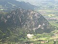
 Kienberg over Pfronten as seen from the Falkenstein castle ruins , from the east |
||
| height | 1533 m above sea level NHN | |
| location |
|
|
| Mountains | Tannheim Mountains in the Allgäu Alps | |
| Dominance | 2.5 km → Breitenberg , 1838 m | |
| Notch height | 228 m ↓ Heaven | |
| Coordinates | 47 ° 33 '58 " N , 10 ° 30' 52" E | |
|
||
| rock | Main dolomite | |

The Kienberg is a 1533 m above sea level. NHN high mountain (height fluctuates between 1533 and 1536 m depending on the source) and at the same time a 3 km long massif between Achtal and Vilstal in the Tannheimer mountains of the Allgäu Alps in the Pfrontens area ( Ostallgäu district ).
Environment and structure
The mountain range is the northern limit of the Tannheimer Berge and is therefore located south of the Edelsberg (1630 m) and the Vilstal and north of the Breitenberg (1838 m) and the Achtal . The Kingdom of Heaven and the Westerkienberg (1488 m) connect to the west , while Pfronten is to the east .
The ridge is divided from east to west into the 1st Pfrontener mountain (1297 m, also Kienberg shoulder ), the 2nd Pfrontener mountain (1357 m, also Leh summit ), the 3rd Pfrontener mountain (1384 m, also Krenge) -Gipfel ), the Schnalskopf (1455 m, also Oberer-Hof-Summit ) and the Kienberg main summit.
Tours and bases
There are no trails on the Kienberg and its ridge itself, but there are some hiking trails around the massif. So find z. B. the forest path Im Ascha near Pfronten-Dorf on the slope of the Kienberg.
Support points in the vicinity of the Kienberg are:
- Milchhäusle, Pfronten village
- Bear moss alp
- Fallmühle, Pfronten village
- Vilstalsäge, Pfronten-Ried
View from the Breitenberg (1838 m) to the three Pfrontener Mountains (1297 m, 1357 m, 1384 m)

View from the Schönkahler (1688 m)

View from Schönkahler to Westerkienberg (left), Breitenberg (right) and Kienberg (middle)


literature
Hiking guide
- Dieter Seibert: Alpine Club Guide - Allgäu Alps and Ammergau Alps , 18th edition, Munich: Bergverlag Rother 2013, ISBN 978-3-7633-1126-2
Maps
- Bavarian Surveying Administration : Tannheimer Berge, Köllenspitze, Gaishorn (Alpenvereinskarte BY5) (1: 25,000), Deutscher Alpenverein (publisher), Munich: 2015, ISBN 978-3-937530-45-1
- Compass : Tannheimer Tal (sheet 04) (1: 35,000), Ostfildern: 2017, ISBN 978-3-85491-644-4
- AVA-Verlag Allgäu : Zumstein hiking map Pfronten (No. 2p) (1: 30,000), Kempten, ISBN 978-3-941869-23-3
Web links and individual references
- ↑ Bavarian Surveying Administration : BayernAtlas . Retrieved April 18, 2018.
- ↑ Dieter Seibert: Alpine Club Guide - Allgäu Alps and Ammergau Alps , 18th edition, Munich: Bergverlag Rother 2013, p. 252
- ↑ Bavarian Surveying Administration : Tannheimer Berge, Köllenspitze, Gaishorn (Alpenvereinskarte BY5), Deutscher Alpenverein (publisher), Munich, 2015