Handsome bald
| Handsome bald | ||
|---|---|---|
|
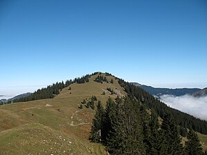
South side of the Schönkahler |
||
| height | 1688 m above sea level NHN | |
| location | Bavaria / Tyrol border | |
| Mountains | Tannheimer Berge , Allgäu Alps | |
| Dominance | 2.5 km → Einstein | |
| Notch height | 208 m ↓ notch to Einstein | |
| Coordinates | 47 ° 32 '25 " N , 10 ° 29' 21" E | |
|
|
||
| rock | lime | |
The Schönkahler is a 1688 m high mountain in the Allgäu Alps .
Location and surroundings
Within the Allgäu Alps , the Schönkahler lies in the group of the Tannheimer Mountains . The border between Germany and Austria runs directly above the summit. The Schönkahler is bounded in the east by the Engetal, in the west by the Vilstal . To the south, the Schönkahler is connected to the Pirschling (1634 m) via a wide saddle . The Schartenhöhe of the Schönkahler is at least 208 meters, its dominance 2.5 kilometers, whereby the Einstein (1866 m) is the reference mountain in each case.
Routes to the summit
The summit is not difficult to reach. Forest paths on the east side lead to the Pfrontener Alpe , which, according to other sources, is also called the Schönkahler Alpe . From there a path leads across alpine meadows into the saddle between Schönkahler and Pirschling. You reach the summit, which is decorated with an approximately three meter high cross, through light forest and pasture areas on the southern flank.
Ski mountaineering
The Schönkahler is an easy and relatively safe destination for ski mountaineers in winter . The ascent takes place either from the east from the Engetal or from the south from the Tannheimer Tal . In order to reduce the impairment of nature by ski tourers in winter , the German Alpine Association, in cooperation with the Bavarian State Ministry for Environment and Health, as well as with local authorities and experts, has identified a route for ascent and descent.
Web links
References and comments
- ^ Boundary stone on the Schönkahler summit, image in Wikimedia Commons
- ↑ Federal Office for Cartography and Geodesy , State Office for Surveying and Geoinformation Bavaria : Digital Topographical Map 1:25 000, [1] , accessed on January 9, 2016.
- ↑ Exact value not known, stated value is a minimum value (can be up to 19 meters higher). It was determined from the distance between the contour lines (20 meters in altitude ) on a topographic map ( scale 1: 25,000).
- ↑ Sign at the eastern foot of the Schönkahler, picture in Wikimedia Commons
- ↑ State Office for Surveying and Geoinformation Bavaria: Füssen and surroundings 1: 50,000 , map of the area, Munich, ISBN 3-86038-013-3 , 2007
- ^ Uli and Dieter Seibert: Skitouren Allgäu , Steiger Verlag, Augsburg, 1996, ISBN 3-89652-025-3 , from page 23
- ↑ Sign at the eastern foot of the Schönkahler, picture in Wikimedia Commons


