Killbuck Creek (Walhonding River)
| Killbuck Creek | ||
|
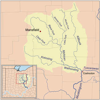
Map of Killbuck Creek within the Walhonding River basin. |
||
| Data | ||
| Water code | US : 1066785 | |
| location | Northeast Ohio , USA | |
| River system | Mississippi River | |
| Drain over | Walhonding River → Muskingum River → Ohio River → Mississippi River → Gulf of Mexico | |
| origin | northern Wayne County, Ohio 40 ° 55′0 ″ N , 81 ° 58′51 ″ W. |
|
| Source height | 344 m | |
| muzzle | Walhonding River, 8 km west of Coshocton, Ohio Coordinates: 40 ° 19 ′ 44 " N , 81 ° 56 ′ 21" W, 40 ° 19 ′ 44 " N , 81 ° 56 ′ 21" W |
|
| Mouth height | 232 m | |
| Height difference | 112 m | |
| Bottom slope | 0.85 ‰ | |
| length | 132 km | |
| Catchment area | 1588 km² | |
The Killbuck Creek is a 132 km long tributary of the Walhonding River in the northeast of the US state Ohio . The water of the river with a catchment area of 1,588 km² reaches the Mississippi via the Walhonding, Muskingum and Ohio Rivers . 35% of the catchment area consists of forest, followed by arable land with 29% and pastures with 22%, while around 10% is built on.
Killbuck Creek rises in northern Wayne County , flows south first and then swings southwest into Medina County . After passing the city of Burbank, it turns south again and meanders through the counties of Holmes and Coshocton , finally reaching the confluence with the Walhonding River about 8 km west of the city of Coshocton . On his way south he touches Wooster in Wayne County and Holmesville , Millersburg and Killbuck in Holmes County.
The name of the river comes from the Delaware chief Killbuck or Gelelemend , who lived in this area for a while in the 18th century. Since 1963, the river has been officially called Killbuck Creek according to the United States Board on Geographic Names . Previously it was also called Killbuck Run , Killbucks Creek , Kilbuck River or similar spellings.
Individual evidence
- ↑ a b Google Earth altitude for GNIS coordinates, accessed on July 25, 2010.
- ↑ a b c Killbuck Creek (Walhonding River) in the Geographic Names Information System of the United States Geological Survey , accessed July 25, 2010
- ↑ Ohio Environmental Protection Agency ( page no longer available , search in web archives ) Info: The link was automatically marked as defective. Please check the link according to the instructions and then remove this notice. , accessed July 25, 2010
