Kilmes (river)
|
Kilmes Кильме́зь, Калмез |
||
| Data | ||
| Water code | RU : 10010300512111100038569 | |
| location | Udmurt Republic , Kirov Oblast ( Russia ) | |
| River system | Volga | |
| Drain over | Vyatka → Kama → Volga → Caspian Sea | |
| source | around 30 km west of Fakel 57 ° 37 ′ 26 ″ N , 52 ° 31 ′ 38 ″ E |
|
| muzzle | at Ust-Kilmes in the Vyatka coordinates: 56 ° 57 ′ 15 ″ N , 50 ° 28 ′ 12 ″ E 56 ° 57 ′ 15 ″ N , 50 ° 28 ′ 12 ″ E
|
|
| length | 270 km | |
| Catchment area | 17,200 km² | |
| Discharge at the Witschmar gauge |
MQ |
82 m³ / s |
| Left tributaries | Arlet , Wala | |
| Right tributaries | Pest , Ut , Kyrtschma , Lumpun Loban , Kulma | |
| Communities |
Kilmes (Udmurtia), Kilmes (Kirov Oblast) |
|
|
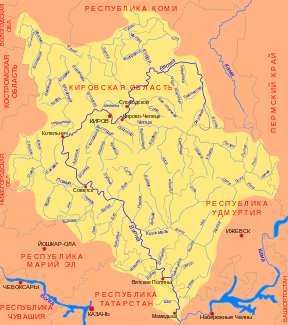
Course of the Kilmes (Кильмезь) in the catchment area of the Vyatka |
||
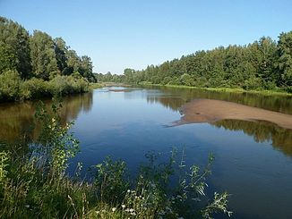
The Kilmes ( Russian Кильме́зь ; udmurtisch Калмез ) is a left tributary of the Vyatka in the European part of Russia .
With a length of 270 km and a catchment area of 17,200 km², it is the second largest tributary of the Vyatka.
course
The Kilmes has its source in the northern Udmurt Republic in the Kama Heights . From there it flows primarily in a southerly direction through the densely forested, hilly northern center of Udmurtia.
After the confluence of the Arlet , it turns to the west and south-west. It meanders through the swampy area and takes on numerous streams and small rivers. Around 50 northeast of Kilmes , the Kilmes turns south, shortly before the village it turns again to the west. Below Kilmes, the river crosses the border with Kirov Oblast .
In Kirov Oblast, the Kilmes continues to flow very curvy towards the west. It forms numerous oxbow lakes and finally reaches the Vyatka at Ust-Kilmes .
use
The Kilmes is frozen on average from the beginning of November to the second half of April. The river is used by boat travelers . The middle course of the river is 10–60 m, on the border between Udmurtia and Kirov Oblast up to 75 m wide, between 0.5 and 3 m deep and runs in a valley up to 3 km wide. The Kilmes is mainly fed by melt water.
Web links
Individual evidence
- ↑ a b c d e Article Kilmes in the Great Soviet Encyclopedia (BSE) , 3rd edition 1969–1978 (Russian)
- ↑ a b Kilmes in the State Water Register of the Russian Federation (Russian)
- ↑ a b Ryschawski, G. Ja .: По Каме и её притокам (To the Kama and its tributaries) . In: Физкультура и спорт , Moscow 1986 (russ.)

