Kirchau
|
Kirchau ( village ) locality |
||
|---|---|---|
|
|
||
| Basic data | ||
| Pole. District , state | Neunkirchen (NK), Lower Austria | |
| Judicial district | Neunkirchen | |
| Pole. local community | Warth ( KG Warth) | |
| Coordinates | 47 ° 39 ′ 19 ″ N , 16 ° 5 ′ 24 ″ E | |
| height | 440 m above sea level A. | |
| Residents of the village | 295 (January 1, 2020) | |
| surface | 7.145 km² | |
| Post Code | 2831 | |
| Statistical identification | ||
| Locality code | 05328 | |
| Source: STAT : index of places ; BEV : GEONAM ; NÖGIS | ||
Kirchau is a village and cadastral community of the Warth municipality in the Neunkirchen district in Buckligen Welt in Lower Austria .
geography
58% of the local area are forest and 35% are fields, meadows and pastures.
Kirchau is located on the L143 state road about 2.5 km west of Warth in the Haßbachtal and about 3 km east of Haßbach.
structure
The village consists of the village of Kirchau and the Rotten Laa, Kleineben, Schachen, Leiding and Palm and several individual layers. To the south, Kirchau borders on the community of Grimmenstein , with which it operates a joint volunteer fire brigade.
With the Lower Austria. In 1968 Kirchau was incorporated into the municipality of Warth.
history
Kirchau was mentioned in a document as early as 1146, and the Stubenberg ruins also date from this time .
Culture and sights
- Stubenberg ruins
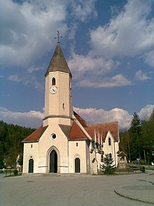
- Catholic parish church Kirchau hl. Margareta
- Former cemetery with a war memorial south of the church
- Marienkapelle north of the church
literature
- The art monuments of Austria. Dehio Lower Austria south of the Danube 2003 . Kirchau, Warth parish, parish church St. Margareta, former Cemetery, Marienkapelle, Stubenberg / Gutenbrunn castle ruins, small monuments. Pp. 934-935.
Web links
Individual evidence
- ^ History of the market town of Warth on warth-noe.gv.at


