
Small courtyards
| Small courtyards | ||
|---|---|---|
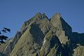
 Small Höfats from the Höfats -Ostgipfel |
||
| height | 2073 m | |
| location | Bavaria , Germany | |
| Mountains | Höfats and Rauheck Group , Allgäu Alps | |
| Dominance | 0.2 km → Höfats | |
| Notch height | 113 m ↓ notch to Höfats | |
| Coordinates | 47 ° 22 '0 " N , 10 ° 21' 16" E | |
|
||
| First ascent | by locals | |

The Kleine Höfats is a 2,073 m high grass mountain in the Allgäu Alps .
Location and surroundings
It lies in the ridge that strikes northeast from the second summit of the Höfats .
The notch height of the Kleine Höfats is at least 113 meters, their dominance 200 meters, with the Höfats reference mountain in each case.
Ascent
There is no marked path to the Kleine Höfats. All climbs are very exposed and more or less difficult grass climbs and require good climbing experience, a head for heights and absolute surefootedness in the Schrofen area . The Kleine Höfats is rarely climbed. The summit book of the Kleine Höfats dates back to the 1950s.
Routes
East ridge
- Difficulty: I +
- Time required: 2 hours
- Starting point: Käseralpe
- First climber: unknown
- Note: grass and crag climbing, sometimes very exposed, poor security options
Northeast ridge
- Difficulty: II +
- Time required: 1 hour
- Starting point: Oberloch
- First climber: unknown
- Note: grass and crag climbing, sometimes very exposed, poor security options
from Schärtele
- Difficulty: III
- Time required: 1 hour
- Starting point: Red Hole
- First climber: unknown
- Note: grass and crag climbing, sometimes very exposed, poor security options. Direct ascent to the summit IV
South wall
- Difficulty: V +
- Time required: 2 hours
- Starting point: Red Hole
- First rider: Schwarz, Proud, 1933
- Note: hardly used any more
photos

Small Höfats from Älpelesattel
Small Höfats from Gaisbachtobelweg. In the background the Höfats and in the foreground the rope hangman

The Kleine Höfats vom Schneck in front of the Höfats . Right at the bottom the rope hangman
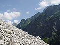
Small Höfats (the distinctive point a little to the right of the center of the picture) from the lower area of the glide path


literature
- Thaddäus Steiner : Allgäuer Bergnames , Lindenberg, Kunstverlag Josef Fink, 2007, ISBN 978-3-89870-389-5
- Thaddäus Steiner: The field names of the municipality of Oberstdorf im Allgäu , Munich, self-published by the Association for Field Name Research in Bavaria, 1972
- Zettler / Groth: Alpine Club Guide Allgäu Alps . Munich, Bergverlag Rudolf Rother 1984. ISBN 3-7633-1111-4
Web links
Remarks
- ↑ Exact value not known, stated value is a minimum value (can be up to 19 meters higher). It was determined from the distance between the contour lines (20 meters in altitude ) on a topographic map ( scale 1: 25,000).