Höfats- and Rauheck group
| Höfats- and Rauheck group | ||
|---|---|---|
| Highest peak | Rauheck ( 2384 m ) | |
| location | Bavaria , Germany / Tyrol , Austria | |
| part of | Allgäu Alps | |
| Classification according to | Alpine Club Guide Allgäu Alps | |
|
|
||
| Coordinates | 47 ° 21 ′ N , 10 ° 21 ′ E | |
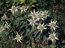
The Höfats and Rauheck Group is a subgroup of the Allgäu Alps in Germany and Austria . At 2384 meters, the Rauheck is the highest peak in the subgroup. The second namesake for the group is the famous steep Grasberg Höfats (2259 m). The main rock, spotted marl, provides a great botanical diversity, for example edelweiss is very common on the Höfats.
Boundaries and surroundings
Starting from Gruben in the Trettachtal , the border of the subgroup runs through the valley to the south to Spielmannsau . Here the valley of the Traufbach branches off to the southwest and leads up to the Sattel im Märzle (2201 m) and to the east down into the Hornbachtal . At the confluence with the Jochbach , the border turns west up to the Hornbachjoch (2020 m) and from here down the Oytal back to Gruben.
Surrounding subgroups in the north are the Thumb and Hochvogel groups , with which there is a connection via the Hornbachjoch. In the south is the Hornbach chain , to which it goes over the saddle in the Märzle. To the west lies the central main ridge .
The subgroup is predominantly located on German territory and in the state of Bavaria . Between the saddle in Märzle and the Hornbachjoch runs over the ridge of Rauheck and Kreuzeck (2376 m), the state border to Austria and its state of Tyrol . Comprehensive municipal areas are thus Oberstdorf and Hinterhornbach .
mountains

In addition to the highest point of the group, the Rauheck (2384 m), there are other striking mountains in the subgroup. The height is followed by the Kreuzeck (2376 m), the Höfats (2259 m), the Jochspitze (2232 m), Kleine Höfats (2073 m) and the Kegel- (1959 m) and Riffenkopf (1748 m).
geology
Most of the Höfats and Rauheck groups are made up of marl and aptych limestone . From the peaks towards the valley there is also a main dolomite , for example in the area of the Höfats and the Riffenkopf .
Waters
The only lake in the subgroup is the ice lake north of the Rauheck.
botany
The geological condition ensures botanical richness. Due to the aptych limestone and chert, there are around 400 plant species on the Höfats , including alpine houseleek , mountain leek , mountain pippau , single-headed piglet , the rare sweet cabbage , tragacanth species and hawk herbs as well as large edelweiss canes. Long-tailed violets , Carpathian cat paws , alpine sweet clover and small motherwort grow on the ridge of the Rauh- and Kreuzeck .
Alpinism
There are no overnight bases within the subgroup available for tours in the Höfats and Rauheck groups. In addition to the direct, wide access from the valleys around Oberstdorf and Hinterhornbach, it is possible to use the Kemptner Hütte (1844 m) to the west .
Hiking and mountaineering
The marked transition between the Kemptner Hütte and the Prinz-Luitpold-Haus (1846 m) runs over the Kreuzeck-Rauheck-Kamm . Otherwise only the top of the yoke can be reached with a marked trail. Other paths lead from the valleys up to the Älpelesattel and the Hornbachjoch.
Climb
The only worthwhile climbing destinations in this subgroup are Höfats and Kleine Höfats. The crossing of the four Höfatsgipfel moves between the II.-III. Degree . The north ridge and south-west ridge, which was first climbed in 1904, are rated IV, as is the south-east face of the east summit. The routes in the north face of the second summit are more difficult, here the western lead has the V degree, the eastern lead and the straight north face have the difficulty VI. The west face of the west summit has the same difficulty. The north face of the east summit is rated V +. The northeast ridge with III can be found on the Kleine Höfats. and the south wall with V +. At the Seilhenker , a hilltop on the Kleine Höfats, there was a VI + route through the northeast face, which is no longer used today because the wall has broken off. The east edge is a grade IV climb.
literature
- Dieter Seibert: Alpine Club Guide alpine - Allgäu Alps and Ammergau Alps . 17th edition. Bergverlag Rother, Munich 2008, ISBN 978-3-7633-1126-2 (pp. 297–306)
- Ernst Zettler, Heinz Groth: Alpine Club Guide - Allgäu Alps . 12th, completely revised edition. Bergverlag Rudolf Rother, Munich 1985, ISBN 3-7633-1111-4 (pp. 240–245, 397–413)
Web links
References and comments
- ↑ Dieter Seibert: Alpine Club Guide alpine - Allgäu Alps and Ammergau Alps . 17th edition. Bergverlag Rother , Munich 2008 (p. 297f).
- ↑ a b Kompass hiking, bike and ski tour map: Sheet 3 Allgäu Alps, Kleinwalsertal (1: 50,000). ISBN 978-3-8549-1005-3 (January 2005).
- ↑ Federal Office for Metrology and Surveying Austria: Austrian Map online . Retrieved November 12, 2010.
- ↑ This list includes mountains with a secured notch height of over 100 meters.
- ^ Herbert Scholz: Building and Becoming the Allgäu Landscape . E. Schweizerbart'sche Verlagsbuchhandlung (Nägele and Obermiller), Stuttgart 1995, ISBN 3-510-65165-0 (pp. 49f, 58f).
- ↑ Gaby Funk: What is blooming there? - On a flower tour in the German-Austrian border area . (Pp. 28–33) In: Bergsteiger 7/2009. Bruckmann Verlag , Munich.
- ↑ Ernst Zettler, Heinz Groth: Alpine Club Guide - Allgäu Alps . 12th, completely revised edition. Bergverlag Rudolf Rother, Munich 1985 (pp. 402-408).
- ↑ Ernst Zettler, Heinz Groth: Alpine Club Guide - Allgäu Alps . 12th, completely revised edition. Bergverlag Rudolf Rother, Munich 1985 (p. 409f).


