
Little Röder (Big Röder)
| Little Röder | ||
.jpg) Course from the source north of Leppersdorf to the confluence with the Große Röder near Ottendorf-Okrilla |
||
| Data | ||
| Water code | DE : 53844 | |
| location | Bautzen district , Saxony , Germany | |
| River system | Elbe | |
| Drain over | Große Röder → Schwarze Elster → Elbe → North Sea | |
| origin | on Eierberg near Lichtenberg 51 ° 10 ′ 12 ″ N , 13 ° 58 ′ 47 ″ E |
|
| Source height | 302 m above sea level NN | |
| muzzle | from the right in Cunnersdorf (district of Ottendorf-Okrilla ) into the Große Röder Coordinates: 51 ° 10 ′ 44 ″ N , 13 ° 48 ′ 45 ″ E 51 ° 10 ′ 44 ″ N , 13 ° 48 ′ 45 ″ E |
|
| Mouth height | 162 m above sea level NN | |
| Height difference | 140 m | |
| Bottom slope | 7 ‰ | |
| length | 20 km | |
| Left tributaries | Orla | |
| Right tributaries | Mean water | |
| Communities | Wachau , Lichtenberg , Ottendorf-Okrilla | |
 It flows into the Große Röder near Ottendorf-Okrilla |
||
The Kleine Röder or Wilde Röder is an approximately 20 km long watercourse in Saxony . It rises on the southwest slope of the Eierberg near Lichtenberg in the Bautzen district at an altitude of approx. 300 meters.
Below Leppersdorf , the stream changes its south-westerly direction of flow to the north, thus following the general roofing of the area. It flows through Kleindittmannsdorf with four former water mills. At the edge of the mighty Okrilla basin sands, the course swings in a westerly direction and forms the southern border of the Mittelheide north of Lomnitz . After the confluence of the mean water from Großnaundorf , the Kleine Röder flows south of the Laußnitzer Heide further west to Ottendorf-Okrilla . It finally joins the Große Röder from the right in the district of Cunnersdorf . Other tributaries are the Orla (source near Feldschlößchen ) from the south and the Lichtenberger Wasser from the north.
There were frequent floods in the catchment area of the Kleine Röder. Larger damage to varying degrees has been documented for the years 1958, 2002, 2006, 2010, 2011, 2012 and 2013. A major flood occurred on August 12 and 13, 2002. This resulted in high damage, particularly in Leppersdorf and Ottendorf-Okrilla. In addition, the stilling basin of the Kleindittmannsdorf reservoir was destroyed.

Source of the Kleine Röder at the foot of the Eierberg

Source of the Kleine Röder, which initially flows to the southwest

Flow through the federal motorway 4 at Leppersdorf near the former Röderbad

The Kleine Röder flows through the village pond of Leppersdorf (in the background the new castle is built)

The Leppersdorfer village pond drains into the Kleine Röder

Kleine Röder and Kleindittmannsdorfer Steig lead north through the federal highway 4
Kleine Röder near Lichtenberg immediately north of the federal motorway 4

A listed bridge south of Kleindittmannsdorf with a boundary stone to the Wachau manor on the bridge
Aerial view of the Kleindittmannsdorf reservoir (looking north towards Kleindittmannsdorf)

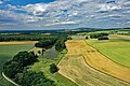
Aerial view of the confluence of the small ones (in the picture coming from the left) into the Große Röder (coming from the right and flowing towards the viewer)


See also
literature
- Hydrological manual. (PDF; 115 kB) Part 2 - Area Codes. Free State of Saxony - State Office for Environment and Geology, p. 9 , accessed on December 25, 2017 .
- Dresdner Heide, Pillnitz, Radeberger Land (= values of our homeland . Volume 27). 1st edition. Akademie Verlag, Berlin 1976, p. 29.