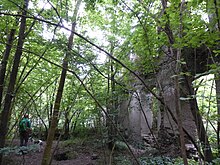
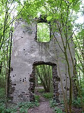
Tönisstein monastery ruins
The Tönisstein monastery ruins , also called Sankt Antoniusstein monastery , are the ruins of a former Carmelite monastery in Bad Tönisstein, a residential area in the Kell district of the city of Andernach ( Rhineland-Palatinate ), which was founded in 1465 . The monastery ruins are protected as a monument .
history
According to a legend , in 1388 a shepherd from Kell in the Tönisstein Valley found a Pietà (miraculous image) with St. Anthony in a burning bush. This was taken as an opportunity to build a chapel on this site in 1390 , which was consecrated to the Mother of God , St. Antonius and St. Wendelin .
The name Sankt Antoniusstein became dialect to Tönisstein (from Tönnes = Anton (ius)). The beginning of the pilgrimages led to the construction of the Carmelite monastery Sankt Antoniusstein in the years 1465 to 1495. The single-nave church was richly furnished by foundations and the monastery was later redesigned into a baroque complex.
The Carmelites already used the spring water for healing purposes, because the Helpert spring in the Pöntertal was first mentioned in a document in 1501. Since 1620 the spa town that was being developed was also called "Tönisstein", like the monastery. In the 17th and 18th centuries, Tönisstein was chosen by the Cologne electors as their favorite bathing and health resort.
In 1802 the monastery was dissolved as a result of secularization and fell into ruin. The image of Mary came to the Catholic parish church of St. Lubentius in Kell.
Trivia
The ruins of the monastery are located on the Höhlen- und Schluchtensteig circular hiking trail , which is one of the dream trails in the Mayen-Koblenz district .
literature
- Werner Fußhöller: The former Antoniusstein monastery in the Brohl valley . In: Heimat-Jahrbuch 2011 Kreis Ahrweiler , ed. from the district of Ahrweiler , Bad Neuenahr-Ahrweiler 2010, pp. 166–168, ISSN 0342-5827 . [not evaluated]
Web links
Coordinates: 50 ° 26 ′ 57.4 " N , 7 ° 17 ′ 52.6" E


