Kodiak Airport
| Kodiak Airport | |
|---|---|

|
|
| Characteristics | |
| ICAO code | PADQ |
| IATA code | ADQ |
| Coordinates | |
| Height above MSL | 24 m (79 ft ) |
| Transport links | |
| Distance from the city center | 7 km southwest of Kodiak , Alaska |
| Basic data | |
| Passengers | 80 303 |
| Flight movements |
40 949 |
| Runways | |
| 07/25 | 2299 m × 46 m asphalt |
| 11/29 | 1646 m × 46 m asphalt |
| 18/36 | 1528 m × 46 m asphalt |
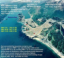
The Kodiak Airport ( IATA: ADQ ; ICAO: PADQ ) is both a civilian and military airport, 7 km southwest of the city of Kodiak on Kodiak Iceland in the US state of Alaska is. There is also a United States Coast Guard station there .
In 2010 the airport recorded 80,303 passengers.
history
The airport is located on the site of the former Naval Air Station Kodiak , which was established in 1941. In 1950, NAS Kodiak closed, with the exception of the Coast Guard facilities.
In 1947, a Coast Guard division was stationed in Kodiak. In 1964, the Coast Guard Air Station Kodiak was installed. In 1971 the United States Navy handed the airport over to the state of Alaska.
Infrastructure and planes
Kodiak Airport has three paved runways:
- 07/25 : 2299 × 46 meters
- 11/29 : 1646 × 46 meters
- 18/36 : 1528 × 46 meters
Between September 5, 2008 and September 4, 2009, the airport recorded 40,949 aircraft movements, an average of 112 per day: 51% air taxi , 6% commercial, 4% general aviation and 39% military.
Airlines and destinations
| airline | Destinations |
|---|---|
| Alaska Airlines | Anchorage |
| Alaska Airlines operated by Horizon Air | Anchorage |
| Era Alaska | Anchorage |
| Island Air Service |
Akhiok , Karluk , Larsen Bay , Old Harbor , Ouzinkie , Port Lions Seasonal: Homer |
| Island Air Service Floatplane Service | Alitak , Amook , Kitoi , Moser Bay , Olga Bay , Port Bailey , Port Williams , Seal Bay , Uganik , West Point , Zachar Bay |
| Servant Air | Akhiok , Karluk , Larsen Bay , Old Harbor , Ouzinkie , Port Lions |