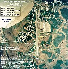
Dillingham Airport
| Dillingham Airport | ||
|---|---|---|
|
|
||
| Characteristics | ||
| ICAO code | PADL | |
| IATA code | DLG | |
| Coordinates | ||
| Height above MSL | 25 m (82 ft ) | |
| Transport links | ||
| Distance from the city center | 4 miles west of Dillingham , Alaska | |
| Basic data | ||
| operator | State of Alaska | |
| surface | 251 ha | |
| Passengers | 42,927 | |
| Flight movements |
50,892 | |
| Start-and runway | ||
| 01/19 | 1951 m × 46 m asphalt | |
The Dillingham Airport ( IATA: DLG; ICAO: PADL ) is a public airport, which km west of the city, 4 Dillingham , in the Alaskan Dillingham Census Area is located.
According to records of the American aviation authority , the airport had 42,927 boardings in 2010.
Infrastructure and planes
Dillingham Airport covers an area of 251 hectares and is located at a height of 25 meters above sea level . The asphalt runway (01/19) is 1951 meters long and 46 meters wide.
Between September 2010 and August 2011, the airport recorded 50,892 aircraft movements: 72% air taxi , 26% general aviation and 3% commercial flights.
Airlines and destinations
| airline | Destinations |
|---|---|
| Alaska Airlines | Anchorage |
| PenAir | Anchorage , Ekwok , King Salmon , Koliganek , Manokotak , New Stuyahok , Togiak , Twin Hills |
Incidents
- On 10 October 2001 an unsuccessful Cessna 208 of PenAir ( air vehicle registration N9530F ), traveling from Dillingham to King Salmon , shortly after the start because of icing . All ten people on board the aircraft died (see also PenAir flight 350 ) .
Individual evidence
- ^ Dillingham Airport ( English ) In: Geographic Names Information System . United States Geological Survey . Retrieved August 4, 2014.
- ↑ Accident report Cessna 208 N9530F , Aviation Safety Network (English), accessed on April 16, 2020.

