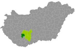
Dombóvár district
| circle Dombóvári járás
Dombóvár |
|
|---|---|
 Location of the district in Hungary |
|
| Basic data | |
| Country | Hungary |
| County | Tolna |
| Seat | Dombóvár |
| surface | 509 km² |
| Residents | 31,192 (January 1, 2016) |
| density | 61 inhabitants per km² |
The Dombóvár District (Hungarian Dombóvári járás ) is a district in the south of the southern Hungarian Tolna County . It borders Tamási County to the north and east . The border is in the south of Hegyhát County ( Baranya County ) and Kaposvár County ( Somogy County ) in the west .
history
During the Hungarian administrative reform in early 2013, the district emerged unchanged from the small area of the same name (Hungarian Dombóvári kistérség ).
Community overview
The Dombóvár District has an average municipality size of 1,950 inhabitants on an area of 31.81 square kilometers. The population density of the district is slightly above the county value of 60 inhabitants / km². The district seat is in the only town, Dombóvár , in the south of the district.
| 16 municipalities | status | Origin small area |
population | Area (km²) | Population density (inh / km²) |
||
|---|---|---|---|---|---|---|---|
| October 01, 2011 | 01/01/2013 | 01/01/2016 | |||||
| Attala | local community | Dombóvár | 858 | 837 | 817 | 20.64 | 39.6 |
| Csibrák | local community | Dombóvár | 300 | 294 | 292 | 14.62 | 20.0 |
| Csikóstőttős | local community | Dombóvár | 864 | 852 | 799 | 17.70 | 45.1 |
| Dalmand | local community | Dombóvár | 1,274 | 1,259 | 1,210 | 48.77 | 24.8 |
| Dombóvár | city | Dombóvár | 19,010 | 19,067 | 18,461 | 78.48 | 235.2 |
| Döbrököz | local community | Dombóvár | 2,033 | 2,026 | 1.961 | 43.13 | 45.5 |
| Gyulaj | local community | Dombóvár | 986 | 1,048 | 995 | 70.82 | 14.0 |
| Jágónak | local community | Dombóvár | 238 | 257 | 257 | 15.40 | 16.7 |
| Kapospula | local community | Dombóvár | 929 | 901 | 840 | 19.80 | 42.4 |
| Kaposszekcső | local community | Dombóvár | 1,508 | 1,504 | 1,493 | 15.62 | 95.6 |
| Kocsola | local community | Dombóvár | 1,318 | 1,303 | 1,266 | 33.34 | 38.0 |
| Kurd | local community | Dombóvár | 1,219 | 1,182 | 1,092 | 31.19 | 35.0 |
| Lápafő | local community | Dombóvár | 168 | 169 | 164 | 9.31 | 17.6 |
| Nak | local community | Dombóvár | 589 | 602 | 578 | 27.78 | 20.8 |
| Szakcs | local community | Dombóvár | 894 | 880 | 811 | 55.79 | 14.5 |
| Várong | local community | Dombóvár | 143 | 152 | 156 | 6.63 | 23.5 |
| Dombóvár district | 32,331 | 32,333 | 31,192 | 509.02 | 61.3 | ||
swell
PDF and XLS files: 2011
Census :
2013:; 2016:
Individual evidence
- ↑ KSH: 2011. Évi Népszámlálás. In: 3. Területi adatok. KSH, accessed on December 29, 2016 (Hungarian, also via: http://www.terezvaros.hu/testuleti/nepsz2011-3/pdf/nepsz2011_03_17.pdf ).
- ↑ KSH: Regional data - Tolna county. KSH, accessed on December 29, 2016 (English, 4th Data on Localities).
- ↑ KSH: Gazetteer of Hungary, 1st January, 2013. KSH, accessed April 12, 2017 (Hungarian / English).
- ↑ KSH: Gazetteer of Hungary, 1st January, 2016. KSH, accessed April 12, 2017 (Hungarian / English).