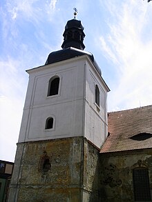
Kuřívody
| Kuřívody | ||||
|---|---|---|---|---|
|
||||
| Basic data | ||||
| State : |
|
|||
| Region : | Liberecký kraj | |||
| District : | Česká Lípa | |||
| Municipality : | Ralsko | |||
| Area : | 4806.6427 ha | |||
| Geographic location : | 50 ° 35 ' N , 14 ° 48' E | |||
| Residents : | 383 (March 1, 2001) | |||
| Postal code : | 471 24 | |||
| License plate : | L. | |||
Kuřívody (German chicken water ) is a district and the administrative seat of the city of Ralsko in Okres Česká Lípa , Czech Republic .
geography
Kuřívody is located ten kilometers southeast of Mimoň in the Kummer Mountains . The state road 268 between Mimoň and Mnichovo Hradiště runs through the village .
history
The place was probably founded during the construction of Bösig Castle . The founding year 1249 mentioned in some writings cannot be proven. 1269 rose Přemysl Ottokar II. The at significant trade route from Prague after Zittau preferred Vristad ( free city ) to the market. From 1279 the owners were the Lords of Krawarn . In 1292 the Berka von Dubá family acquired Vristad. In the 14th century the name Kurziwoda prevailed for the market.
After the Battle of the White Mountain , Bohuchval Berka von Dubá's property, including Weißwasser , was confiscated in 1622 and sold to Albrecht von Waldstein . In the following time the place was settled by Germans and was called Hühnerwasser.
After the abolition of patrimonial , Hühnerwasser formed a market town in the Bunzlauer Kreis and judicial district of Niemes from 1850 with the district of Straßdorf . During the German War , on June 26, 1866, there was a battle near Hühnerwasser between Prussian and Austrian troops. In 1880 the market town in the Bohemian Leipa district had 1277 inhabitants. In 1921, 924 people lived in chicken water. After the Second World War, most of the Germans, who made up about 95% of the population, were expelled. In 1947 the newly arrived Czech population had to vacate the place and the Ralsko military training area was established. After the crackdown on the Prague Spring , the military training area was taken over by the Soviet troops, who largely removed the original urban development and replaced it with barracks and apartment blocks.
After the Soviets withdrew in 1991, the gradual renovation of the place began and it has been repopulated since 1992. The first residents were Volhynian Czechs from the Ukrainian villages Mala Subiwschtschyna ( Malá Zubovština ) in Korosten district and Malyniwka ( Malinovka ) in Malyn district, which were affected by the Chernobyl disaster . In 1991 the place had 524 inhabitants. In 2001 the village consisted of 50 houses in which 383 people lived. Kuřívody became the administrative center of the Ralsko municipality, which was established on the former military training area and was elevated to a town in 2006. On July 14, 2010 the city council decided to reorganize the urban area of Ralsko. From the district of Kuřívody the new district of Jappenček was spun off.
The Strážov desert belongs to the cadastre of Kuřívody .
Attractions
- Church of St. George, partially renovated
- Castle, in ruinous condition
Sons and daughters of the place
- Willibald Gatter (1896–1973), automobile manufacturer


