Kulpmont
| Kulpmont | ||
|---|---|---|
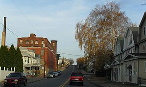
 West Chestnut Street |
||
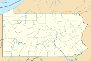
| Location in Pennsylvania | ||
|
|
||
| Basic data | ||
| Foundation : | 1915 (incorporated) | |
| State : | United States | |
| State : | Pennsylvania | |
| County : | Northumberland County | |
| Coordinates : | 40 ° 48 ′ N , 76 ° 28 ′ W | |
| Time zone : | Eastern ( UTC − 5 / −4 ) | |
| Residents : | 2,985 (as of: 2000) | |
| Population density : | 1,297.8 inhabitants per km 2 | |
| Area : | 2.3 km 2 (approx. 1 mi 2 ) of which 2.3 km 2 (approx. 1 mi 2 ) is land |
|
| Height : | 340 m | |
| Postal code : | 17834 | |
| Area code : | +1 570 | |
| FIPS : | 42-40584 | |
| GNIS ID : | 1178705 | |
| Website : | www.boroughofkulpmont.org | |
| Mayor : | Bernard P. Novakoski | |
Kulpmont is a borough in Northumberland County in Pennsylvania , United States . At the time of the 2010 census, Kulpmont had 2924 inhabitants.
geography
Kulpmont's geographic coordinates are 40 ° 48 ′ N , 76 ° 28 ′ W (40.793177, −76.473440).
According to the United States Census Bureau , the borough has a total area of 2.3 km 2 , all of which is land. Even within the borough boundaries, the terrain is heavily reshaped by mining.
The road network is aligned with the course of Pennsylvania Route 61 ; this is called Chestnut Street in the local area. Parallel to the north are Maple, Spruce, Pine, Walnut and Ash Streets, while Oak, Scott, Fir, Poplar and Wood Streets are to the south. Aside from Chesnut Street, only Maple and Oak Streets run through the entire borough. The streets running at right angles to the main axis are numbered, with the numbering beginning with 1st Street in the east and 16th Street in the west being the last street before the border with Coal Township . To the north of Chestnut Street, the numbered streets are prefixed with North and N , respectively, and South and S to the south .
Kulpmont is connected to the directly adjacent Borough of Marion Heights in the northeast via North 6th Street .
The Quaker Run runs through the incorporated area of the borough and further west receives an unnamed tributary from the right that drains the northern part of Kulpmont, while the southern part is drained by the Quaker Run.
history
The Borough of Kulpmont was born on August 24, 1915 incorporated .
Demographics
| Population development | |||
|---|---|---|---|
| Census | Residents | ± in% | |
| 1920 | 4695 | - | |
| 1930 | 6120 | 30.4% | |
| 1940 | 6159 | 0.6% | |
| 1950 | 5199 | -15.6% | |
| 1960 | 4288 | -17.5% | |
| 1970 | 4026 | -6.1% | |
| 1980 | 3675 | -8.7% | |
| 1990 | 3233 | -12% | |
| 2000 | 2985 | -7.7% | |
| 2010 | 2924 | -2% | |
| 2015 estimate | 2851 | -2.5% | |
| Swell: | |||
At the time of the United States Census 2000, 2,985 people lived in Kulpmont. The population density was 1,226.1 people per km 2 . There were 1532 housing units, an average of 629.3 per km 2 . The population in Kulpmont was 98.89% White , 0.47% Black or African American , 0% Native American , 0.03% Asian , 0% Pacific Islander , 0.23% said they were racial , and 0 , 37% named two or more races. 0.54% of the population declared to be Hispanic or Latinos of any race.
The residents of Kulpmont distributed to 1338 households out of which 22.6% were living in children under 18 years of age. 49.5% of households were married, 9.5% had a female householder without a husband and 37.4% were not families. 34.5% of households were made up of individuals and someone lived in 20.0% of all households aged 65 years or older. The average household size was 2.22 and the average family size was 2.85.
The population was divided into 19.6% minors, 5.7% 18–24 year olds, 25.3% 25–44 year olds, 24.1% 45–64 year olds and 25.3% aged 65 and over or more. The median age was 45 years. For every 100 women there were 92.1 men. For every 100 women over 18, there were 87.1 men.
The median household income in Kulpmont was 29,263 US dollars and the median family income reached the amount of 34,674 US dollars. The median income for men was $ 26,679 compared to $ 22,075 for women. The per capita income was $ 16,033. 9.8% of the population and 6.7% of families had an income below the poverty line , including 11.0% of minors and 10.1% of the age group 65 and over.
administration
The mayor of Kulpmont is called Bernie Novakoski. There are also seven municipal councils. Kulpmont is part of the Mount Carmel Area School District .
supporting documents
- ↑ Annual Estimates of the Resident Population for Incorporated Places: April 1, 2010 to July 1, 2015 ( English ) Retrieved October 25, 2016.
- ^ Census of Population and Housing ( English ) US Census Bureau. Retrieved December 11, 2013.
- ↑ American FactFinder ( English ) United States Census Bureau . Retrieved January 31, 2008.
- ↑ Incorporated Places and Minor Civil Divisions Datasets: Subcounty Resident Population Estimates: April 1, 2010 to July 1, 2012 ( English ) In: Population Estimates . US Census Bureau. Retrieved December 11, 2013.
