
La Cochère
| La Cochère | ||
|---|---|---|
|
||
| local community | Gouffern en eye | |
| region | Normandy | |
| Department | Orne | |
| Arrondissement | Lisieux | |
| Coordinates | 48 ° 43 ' N , 0 ° 9' E | |
| Post Code | 61310 | |
| Former INSEE code | 61110 | |
| Incorporation | January 1, 2017 | |
| status | Commune déléguée | |

La Cochere is a village and a former French community with 141 inhabitants (as of January 1 2017) in Orne in the region of Normandy . It belonged to the Arrondissement of Argentan and the Canton of Argentan-2 .
With effect from January 1, 2017, the previous municipalities of Silly-en-Gouffern , Aubry-en-Exmes , Avernes-sous-Exmes , Le Bourg-Saint-Léonard , Chambois , La Cochère , Courménil , Fel , Omméel , Saint-Pierre -la-Rivière , Exmes , Survie , Urou-et-Crennes , Villebadin have merged to form a commune nouvelle called Gouffern en Auge and have the status of a commune déléguée in the new municipality . The administrative headquarters are in Silly-en-Gouffern.
location
Neighboring towns of La Cochère are Silly-en-Gouffern in the northwest, Le Pin-au-Haras in the north, Exmes and Ginai in the northeast, Saint-Germain-de-Clairefeuille in the east, Nonant-le-Pin in the southeast and Almenêches in the southwest.
Population development
| year | 1962 | 1968 | 1975 | 1982 | 1990 | 1999 | 2008 | 2015 |
|---|---|---|---|---|---|---|---|---|
| Residents | 212 | 228 | 197 | 180 | 175 | 138 | 153 | 140 |
Attractions
- Haras national du Pin riding facility , designated as a monument historique since 1948
- Saint-Sauveur church
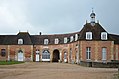
Haras national du Pin riding facility
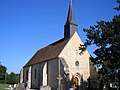
Saint-Sauveur church

