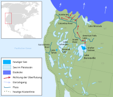
Lake Bonneville
Lake Bonneville is the name for a former lake in the western part of what is now the United States . It existed in a pluvial in the late Pleistocene , during the last Ice Age, and covered large parts of what is now Utah with foothills north to Idaho and west to Nevada . From it emerged the Great Salt Lake and most of Utah's smaller lakes. It was named by Grove Karl Gilbert after Benjamin Bonneville , an officer and fur trader who explored parts of the western Rocky Mountains , the Great Basin, and Oregon .
Around 16,000 years ago, the lake had its greatest extension of around 52,000 km² and thus reached the size of today's Lake Michigan . Its maximum depth was around 300 m. Years ago, some 14,000 broke into the flood Bonneville the lake shore in the north and in a catastrophic flooding event he poured into the plain of the Snake River and laid there and on the Columbia Plateau in places the Columbia River Basalt Group free of today the landscape of Snake- Columbia River System.
In the course of its existence, Lake Bonneville had fluctuating water levels and shorelines, which show up in the form of tuff deposits and terraced bank structures in various parts of Utah. The oldest shoreline is the Stansbury Level , which about 22,000 years ago occupied a water level of 1351 to 1369 m above sea level. This was followed by the Bonneville Level around 16,000 years ago with the highest level at 1,600 m and the Provo Level after the flood disaster 14,500 years ago with 1480–1490 m. The lake reached its lowest point about 11,500 years ago and then rose again to the Gilbert Level 10,000 years ago at 1293–1305 m. Today's water level of the Great Salt Lake is 1283 m. The traces of the various shorelines can best be seen on Antelope Island , an island in the Great Salt Lake.
The cause of the fluctuations was and is, as with all effects of copeia, changes in the climate, both in temperatures and thus in evaporation and precipitation. The minerals, especially the salts, of the lake water, precipitated out during evaporation and concentrated on and in the successively exposed soil. They formed the Great Salt Lake Desert to the west and the Great Salt Lake km² southwest with an area of around 10,360, which is famous for its perfectly smooth surface, which is why on the Bonneville Flats -called race track speed records are set up.
The flood of around 14,000 years ago also left its mark on the landscape: the location of the lake shore break can be found in the vicinity of the Red Rock Pass in southern Idaho, south of Downey . Here the shoreline was formed by sandy alluvial fans of geologically earlier lake structures that gave way under the water pressure. When it broke, the bedrock was exposed, which consists of Cretaceous dolomite , limestone and light brown slate . From here to Pocatello , the valley floor is about 75 km filled with rubble and pebbles from the flood event. Individual chunks were also transported much further.
Trivia
- In the Wasatch Mountains east of Logan there is a stone pillar on the slope above United States Highway US-89 , which marks the level of the water table at the maximum extent of the lake about 16,000 years ago.
- The Bonneville crater on Mars was named after the lake .
- The Triumph Bonneville motorcycle got its name because Triumph and other motorcycle manufacturers set multiple speed records on the dry salt lake.
Web links
- United States Geological Survey: Lake Bonneville and the Bonneville Flood
- Utah Geological Survey: Lake Bonneville (with map)
Individual evidence
- ↑ Utah Geological Survey: Geologic Map of Antelope Island (5.3 MB, map with detailed legend and additional information; PDF)
- ^ Robert C. Bright, H. Thomas Ore: Evidence for the spillover of Lake Bonneville, southeastern Idaho . In: Geological Society of America, Centennial Field Guide - Rocky Mountain Section , Volume 2. Boulder, Colorado, Geological Society of America, 1987, ISBN 0-8137-5406-2 , pages 143-146
- ↑ Digital Atlas of Idaho: Massacre Rocks State Park (accessed March 29, 2016)
Coordinates: 40 ° 30 ′ 0 ″ N , 112 ° 15 ′ 0 ″ W.


