Pluvial
A pluvial (from the Latin pluvialis = rain-bringing, cf. French il pleut = it rains, pluvieux = rainy) is a geological period in climatology and geosciences with higher amounts of rain than the long-term average, especially in northern latitudes the warm periods between individual cold periods . In southern latitudes they also occur under certain conditions during the cold ages themselves, a fact that is discussed in science as a pluvial problem . Cope is proven to be rainy seasons especially during the Quaternary , but especially in the Holocene . In the general sense, in meteorology , a pluvial is also understood to be a regular pattern of increased rainfall that is regionally different, however, as we see it today in the tropics and subtropics with the rainy seasons.
Current climate
Zones in which the water balance is positive, the amount of the annual rainfall therefore the amount of evaporation exceeds, there are from the tropics to the level about the 40th degree of latitude of both hemispheres . Even in the subtropics , which are characterized by high atmospheric pressure, the rate of precipitation exceeds the rate of evaporation, at least above the oceans. In the coastal area of higher latitudes, the precipitation shows its maximum, especially in winter, while in the continental area, which is dominated by the monsoons , the maximums usually occur in summer. Many areas close to the equator have two rainy seasons corresponding to the northward and southward movement of the equatorial low pressure channel with the seasons changing position of the sun . This channel separates the trade winds of the two hemispheres and forms the strong intertropical convergence zone (ITCZ), which is characterized by rapidly rising air currents and heavy precipitation. On the cause of the highly arid situation in the Libyan desert, see there and North Africa .
paleoclimatology
Geological verification possibilities
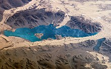
In palaeoclimatology, cope is usually found in connection with unusually heavy precipitation, as can be detected geologically, especially in the tropics and subtropics. The best such evidence make it the well-preserved lakeside terraces are in regions that are now deserts are about Mudpans called old lake basin and bulkheads in the Sahara or in the Lake Bonneville western Utah . Also, the Lake Qarun in the Fayoum Basin and Lake Chad are very good examples of such fossil shorelines. However, the cold periods on earth were on the whole less humid than the warm periods. The terraces on the shores of the sea, for example on the Mediterranean Sea, were not created by this pluvial mechanism, but represent the different stages of cold and warm periods, which the sea level, for example, from 15,000 BP (years before today) to today due to the melting inland glaciers by almost raised a hundred meters.
mechanism
Most scientists have so far seen a connection between the cope with the subtropics and the cold periods at higher latitudes, although precipitation and evaporation decrease globally during such cold periods and the water is increasingly bound in glacier ice . As the ice sheets advance in such periods, the storms' orbits in mid-latitudes also shift towards the equator, causing heavy precipitation in the subtropics, especially in winter. In the beginning, all wet periods, for example in North Africa and the Sahara, were equated with the glacials, and for some cope it is still true today, because here the shift of the rain-bringing west wind belt was and is decisive for these so-called north cope.
The pluvial problem
Recently, however, there has also been another connection between ice age periods and interpluvial periods, i.e. dry periods, in the tropics. Especially tropical lowlands were apparently dry during the last glaciation and moist during the postglacial periods, so the problem has to be seen in a more differentiated manner. For example, during the Spät-Würm in the catchment area of the Nile, the tropical rain stopped completely, and the Sahara dunes reached 1000 km further south than today, apparently because the equatorial rain belt was massively reduced back then. But there was also the opposite effect during the interglacial , when the rain-bringing southwest monsoon pushed far north and developed so-called southern cope, as we currently have them in summer.
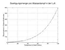
Basically, the evaporation during cold periods is lower (approx. 20%) due to the lower temperatures, also in the subtropics and tropics (up to 8 ° C lower), since the physical capacity for water in the atmosphere decreases with the temperature. This means that more water remains on the ground, lakes and rivers are larger (such as Lake Chad) and carry more water, as can be demonstrated for the Nile and its archaeologically important terraces. On the other hand, the precipitation is lower for this reason, so that a rather unstable hydrological equilibrium is created, which forms the physical basis of the so-called pluvial problem. Complicating this multifactorial occurrence, as it is typical for climatic processes anyway, is the fact that the evaporation, on the other hand, is increased in the case of much larger water areas, especially inland, which also leads to a cooling.
A particularly spectacular case is the now proven incursion of the Mediterranean into the Black Sea basin with the much smaller Euxeinos Lake there around 6700 BC. BC, which is occasionally associated with the mythical Flood . The climatic consequences were just as dramatic as the event itself. At that time a small ice age began in the Black Sea region, which in turn began in 5800 BC. Was ended by a period of sudden warming when the climatic equilibrium stabilized at a new level. The result was the spread of agriculture in the Neolithic there . Due to this rather complex situation, in which additional factors such as ocean currents, salinity , solar effects, the effect of aerosols etc. play a further role that has not yet been quantified more precisely, a distinction is now made between spatially relatively limited glacial and large interglacial cope , where the periods of great aridity fall mainly in the cold ages. This is in good agreement for the Sahara, and the same is true for South Asia, where the increased Central Asian high has a steering effect, which influences the monsoons there . However, the narrow cope with the Mediterranean basin is completely absent in West Pakistan and India, as a result of a completely different topographical situation.
Pluvial lakes were particularly common and extensive in North America , mostly in basins without a runoff. They are mainly found in the large basins of Utah , California , Nevada and Oregon , as well as in other regions of the North American southwest and in Mexico. The largest was Lake Bonneville , the precursor to the great Utah salt lake . At its greatest expansion 15,000 years ago, it covered 51,000 square kilometers and was up to 370 m deep. Another pluvial lake of this size was Lake Lahontan (now Pyramid Lake ). There were two pluvial maxima here: 12,000 ± 500 BP (the beginning of the Allerød warm phase) and 9,000 ± 500 BP (the early boreal ). But also in Hungary on Lake Balaton and in East Africa on Lake Victoria there are similar lake terraces for both periods. Comparable terraces can also be found in Central Asian lakes.
literature
- H. Harmann: History of the Flood . CH Beck Verlag, Munich 2003, ISBN 3-406-49465-X .
- St. Kröpelin: Investigations into the sedimentation environment of Playas in Gilf Kebir (Southwest Egypt). In: R. Kuper (Ed.): Research on the environmental history of the Eastern Sahara. Heinrich Barth Institute, Cologne 1989, ISBN 3-927688-02-9 , pp. 183-305.
- HH Lamb: Climate and Cultural History. The influence of the weather on the course of history . Rowohlt Taschenbuch Verlag, Hamburg 1994, ISBN 3-499-55478-X .
- K. Neumann: Vegetation history of the Eastern Sahara in the Holocene. In: R. Kuper (Ed.): Research on the environmental history of the Eastern Sahara. Heinrich Barth Institute, Cologne 1989, ISBN 3-927688-02-9 , pp. 13-182.
- R. Schild, F. Wendorf, AE Close: Northern and Eastern Africa Climate Changes Between 140 and 12 Thousand Years Ago. In: F. Klees, R. Kuper (eds.): New Light on the Northeast African Past, Symposium Cologne 1990. Heinrich Barth Institute, Cologne 1992, ISBN 3-927688-06-1 , pp. 81-98.
- M. Schwarzbach: The climate of prehistory. An Introduction to Paleoclimatology . Ferdinand Enke Verlag, Stuttgart 1993, ISBN 3-432-87355-7 .
- The New Encyclopedia Britannica . 15th edition. Encyclopedia Britannica, Chicago 1993, ISBN 0-85229-571-5 .
Individual evidence
- ↑ Schwarzbach: Climate of the past. 1993, p. 253.
- ↑ Lamb: Climate and Cultural History. 1994, pp. 129-131.
- ^ Neumann: Vegetation history of the Eastern Sahara. 1989, p. 153.
- ^ Kröpelin: sedimentation environment of Playas. 1989, pp. 283-286.
- ↑ Schwarzbach: The climate of the past. 1993, pp. 224f.
- ↑ Haarmann: History of the Flood. 2003, p. 19f.


