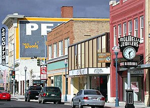
Pocatello
| Pocatello | ||
|---|---|---|
| Nickname : US Smile Capital | ||
 Historic pocatello |
||
| Location in Idaho | ||
|
|
||
| Basic data | ||
| Foundation : | 1889 | |
| State : | United States | |
| State : | Idaho | |
| County : | Bannock County | |
| Coordinates : | 42 ° 53 ′ N , 112 ° 27 ′ W | |
| Time zone : | Mountain ( UTC − 7 / −6 ) | |
|
Inhabitants : - Metropolitan Area : |
54,746 (as of 2016) 84,377 (as of 2016) |
|
| Population density : | 748.9 inhabitants per km 2 | |
| Area : | 73.1 km 2 (approx. 28 mi 2 ) | |
| Height : | 1360 m | |
| Area code : | +1 208 | |
| FIPS : | 16-64090 | |
| GNIS ID : | 0397053 | |
| Website : | www.pocatello.us | |
| Mayor : | Roger W. Chase | |
Pocatello is the administrative seat and with approx. 55,000 inhabitants at the same time the largest city of the Bannock County in the US state Idaho .
geography
Pocatello is 1,360 meters above sea level in the Snake River Plain in southwest Idaho and extends into Power County . Pocatello is surrounded by the Fort Hall Indian Reservation , where the Shoshone-Bannock Indians live. The city emerged as a trading post for fur traders and grew thanks to a gold rush and as a stopping point for the Utah and Northern Railway , one of the most important east-west connections for inner-American freight traffic .
climate
| Pocatello, Idaho | ||||||||||||||||||||||||||||||||||||||||||||||||
|---|---|---|---|---|---|---|---|---|---|---|---|---|---|---|---|---|---|---|---|---|---|---|---|---|---|---|---|---|---|---|---|---|---|---|---|---|---|---|---|---|---|---|---|---|---|---|---|---|
| Climate diagram | ||||||||||||||||||||||||||||||||||||||||||||||||
| ||||||||||||||||||||||||||||||||||||||||||||||||
|
Monthly average temperatures and rainfall for Pocatello, Idaho
|
|||||||||||||||||||||||||||||||||||||||||||||||||||||||||||||||||||||||||||||||||||||||||||||||||||||||||
history
The name Pocatello comes from the Indian chief Pocatello, who approved the construction of the railway through the Indian reservation.
Population development
| year | Residents¹ |
|---|---|
| 1980 | 46,340 |
| 1990 | 46.117 |
| 2000 | 51,466 |
| 2010 | 54,255 |
| 2016 | 54,746 |
¹ 1980-2010 : census results
Attractions
The old town center with its historical buildings is well worth seeing, including the Pocatello High School, which was founded in 1897. The old railway systems of the Union Pacific Railroad are also noteworthy . There are 2 museums in the city: Bannock County Historical Museum and Idaho Museum of Natural History.
education
The Idaho State University (abbreviated ISU) is that the most important with about 13,000 students universities of the state, is the largest employer in the city.
Movie location
Pocatello is the hometown of Mormon missionary Aaron Davis in the film Latter Days and the location of several scenes in the second half of the film.
Twin cities
Trivia
According to a survey by the North American Vexillological Association, Pocatello was ranked last of the 150 best city flags in the United States in 2012. The flag included the city name, an advertising logo, slogan, and even copyright notices. Due to criticism, the city adopted a new, better designed flag in 2017.
sons and daughters of the town
- Steven Bach (1938–2009), film producer and author
- Larry Barrett (1955-2014), singer / songwriter
- Nick Lyon (* 1975), director and screenwriter
- Matt Shriver (* 1980), cyclocross and road cyclist
- Reo Wilde (* 1973), archer (compound)
- Taysom Hill (* 1990) American football player
Individual evidence
- ↑ American City Flags Survey ( Memento from July 16, 2012 in the Internet Archive )
